TopoQuest Logo
Do you find TopoQuest useful?
Help keep TopoQuest running and adding new maps/features by donating!
Bitcoin:  19c7KJd3qBynnjoSw5npx9KScwjBe4ifkT
Litecoin:  LXs6TkuXGGXo1vDsWCkWVdjQX94eUKd6ui
Home View Maps Find Maps Find Places Resources & Links


Dallas City, Illinois Topographic Map

USGS Map Title: Dallas City, IL
USGS Map MRC: 40091F2
DRG (GeoTIFF) Download: o40091f2.tif


Neighboring USGS Topographic Map Quads:


  Danville, IA  
40091G3
 

  West Burlington, IA  
40091G2
 

  Burlington, IA  
40091G1
 

  Fort Madison, IA  
40091F3
 

  Dallas City, IL  
40091F2
 

  Lomax, IL  
40091F1
 

  Niota, IL  
40091E3
 

  Colusa, IL  
40091E2
 

  Burnside, IL  
40091E1


Map MRC Location:

N41°
W92°
N41°
W91°
H8 H7 H6 H5 H4 H3 H2 H1
G8 G7 G6 G5 G4 G3 G2 G1
F8 F7 F6 F5 F4 F3 F2 F1
E8 E7 E6 E5 E4 E3 E2 E1
D8 D7 D6 D5 D4 D3 D2 D1
C8 C7 C6 C5 C4 C3 C2 C1
B8 B7 B6 B5 B4 B3 B2 B1
A8 A7 A6 A5 A4 A3 A2 A1
N40°
W92°
N40°
W91°

Dallas City, IL USGS 1:24K Topographic Map Preview:
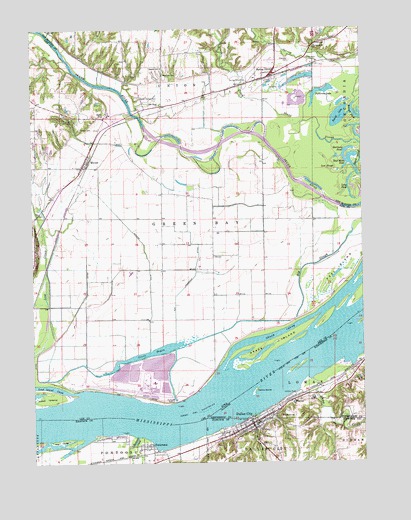
Dallas City, IL USGS Topographic Map
Click on map above to begin viewing in our Map Viewer.

This topographic map contains these locations and features:
Feature Name Type Latitude Longitude GNIS ID View Map
Beebe CemeteryCemeteryN40.7253°W91.2222°454478View Map
Big SloughStreamN40.6434°W91.1968°454625View Map
Blackhawk BottomsParkN40.7334°W91.1376°1994971View Map
Brush CreekStreamN40.7203°W91.1776°454886View Map
Burk's Run Wildlife AreaParkN40.6945°W91.2418°1981064View Map
Camp CreekStreamN40.6489°W91.1449°405452View Map
Chandler CemeteryCemeteryN40.7407°W91.1518°455342View Map
City of Dallas CityCivilN40.6353°W91.1644°2393708View Map
Dallas CityPopulated PlaceN40.6362°W91.1674°406930View Map
Dallas City High SchoolSchoolN40.6367°W91.1651°1812478View Map
Dallas City Post OfficePost OfficeN40.6366°W91.1672°2788482View Map
Dallas City QuarryMineN40.6425°W91.1513°1986087View Map
Dallas City Rural Fire StationBuildingN40.6355°W91.1679°2640863View Map
Dallas IslandIslandN40.6456°W91.1657°406931View Map
Eureka SchoolSchoolN40.7392°W91.2010°456403View Map
Grace Bible ChurchChurchN40.7106°W91.2310°1981293View Map
Grape ChuteStreamN40.6520°W91.1799°457078View Map
Grape IslandIslandN40.6595°W91.1590°457079View Map
Green Bay AccessLocaleN40.6523°W91.1815°1981061View Map
Green BayouLakeN40.6564°W91.2068°457097View Map
Half Moon LakeLakeN40.7123°W91.1296°457203View Map
Hartman PondLakeN40.7127°W91.1300°457301View Map
Indian Path ParkParkN40.7237°W91.2363°1981065View Map
Jollyville HillSummitN40.6864°W91.2360°465326View Map
Jollyville Post Office (historical)Post OfficeN40.6870°W91.2496°466393View Map
KBKB-FM (Fort Madison)TowerN40.7237°W91.2304°467326View Map
Lead IslandIslandN40.6437°W91.2460°458258View Map
Long CreekStreamN40.7487°W91.2438°458592View Map
Long PondLakeN40.7014°W91.1292°458597View Map
Lost SloughLakeN40.7089°W91.1340°458635View Map
Miller Family PlotCemeteryN40.7445°W91.1918°1995145View Map
Mohnike CemeteryCemeteryN40.7369°W91.1999°459163View Map
Mount Ayr Wastewater Treatment PlantLocaleN40.7044°W91.2425°2723881View Map
Oak Grove ChurchChurchN40.7284°W91.2015°459697View Map
Old Township DitchCanalN40.6745°W91.1949°459844View Map
Opossum CreekStreamN40.6270°W91.2138°415147View Map
PattersonPopulated PlaceN40.7398°W91.1399°464320View Map
Patterson LakeLakeN40.7319°W91.1398°460043View Map
Peel IslandIslandN40.6803°W91.1349°460058View Map
PontoosucPopulated PlaceN40.6289°W91.2054°416011View Map
Rogers DitchCanalN40.6862°W91.2079°460765View Map
Round LakeLakeN40.7247°W91.1314°460825View Map
Skunk RiverPopulated PlaceN40.7267°W91.2007°464341View Map
Skunk River AccessLocaleN40.7259°W91.2129°1981066View Map
Sourwine CemeteryCemeteryN40.7473°W91.1335°1995144View Map
South Walker CemeteryCemeteryN40.7304°W91.2093°461819View Map
Spillman CreekStreamN40.6328°W91.2107°418905View Map
Spring GrovePopulated PlaceN40.7398°W91.1582°461891View Map
Spring Grove (historical)LocaleN40.7398°W91.1582°1994906View Map
Spring Grove CemeteryCemeteryN40.7345°W91.1681°461892View Map
Spring Grove ChurchChurchN40.7456°W91.1424°461896View Map
Spring Lake CampgroundLocaleN40.7384°W91.1446°1994972View Map
Terney CemeteryCemeteryN40.7215°W91.2316°462196View Map
The RidgeIslandN40.6312°W91.2401°419640View Map
Township of ConcordiaCivilN40.7393°W91.1251°467651View Map
Township of Green BayCivilN40.6843°W91.2013°467968View Map
Village of PontoosucCivilN40.6284°W91.2112°2398998View Map
WeverPopulated PlaceN40.7106°W91.2310°462957View Map
WeverLocaleN40.7106°W91.2285°1981291View Map
Wever Fire and Rescue DepartmentBuildingN40.7109°W91.2299°2577184View Map
Wever Post OfficePost OfficeN40.7106°W91.2310°1981292View Map

Note: Coordinates in the location and feature list above are referenced to NAD83 datum.


Copyright (C) 2008-2025 Ryan Niemi / Sunset Dynamics ... All Rights Reserved