TopoQuest Logo
Do you find TopoQuest useful?
Help keep TopoQuest running and adding new maps/features by donating!
Bitcoin:  19c7KJd3qBynnjoSw5npx9KScwjBe4ifkT
Litecoin:  LXs6TkuXGGXo1vDsWCkWVdjQX94eUKd6ui
Home View Maps Find Maps Find Places Resources & Links


Danville, Iowa Topographic Map

USGS Map Title: Danville, IA
USGS Map MRC: 40091G3
DRG (GeoTIFF) Download: o40091g3.tif


Neighboring USGS Topographic Map Quads:


  New London, IA  
40091H4
 

  Pleasant Grove, IA  
40091H3
 

  Sperry, IA  
40091H2
 

  Lowell, IA  
40091G4
 

  Danville, IA  
40091G3
 

  West Burlington, IA  
40091G2
 

  West Point, IA  
40091F4
 

  Fort Madison, IA  
40091F3
 

  Dallas City, IL  
40091F2


Map MRC Location:

N41°
W92°
N41°
W91°
H8 H7 H6 H5 H4 H3 H2 H1
G8 G7 G6 G5 G4 G3 G2 G1
F8 F7 F6 F5 F4 F3 F2 F1
E8 E7 E6 E5 E4 E3 E2 E1
D8 D7 D6 D5 D4 D3 D2 D1
C8 C7 C6 C5 C4 C3 C2 C1
B8 B7 B6 B5 B4 B3 B2 B1
A8 A7 A6 A5 A4 A3 A2 A1
N40°
W92°
N40°
W91°

Danville, IA USGS 1:24K Topographic Map Preview:
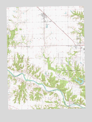
Danville, IA USGS Topographic Map
Click on map above to begin viewing in our Map Viewer.

This topographic map contains these locations and features:
Feature Name Type Latitude Longitude GNIS ID View Map
AugustaPopulated PlaceN40.7581°W91.2757°454282View Map
Augusta AccessLocaleN40.7523°W91.2768°1981068View Map
Augusta CemeteryCemeteryN40.7612°W91.2668°1995183View Map
Augusta Post Office (historical)Post OfficeN40.7581°W91.2757°1995110View Map
Blakeway CemeteryCemeteryN40.8125°W91.3518°1823516View Map
City of DanvilleCivilN40.8600°W91.3146°2393716View Map
City of MiddletownCivilN40.8273°W91.2622°2395316View Map
Congregational United ChurchChurchN40.8645°W91.3138°1995091View Map
Creamer CemeteryCemeteryN40.7656°W91.3729°1823513View Map
DanvillePopulated PlaceN40.8645°W91.3146°455791View Map
DanvilleLocaleN40.8667°W91.3132°1995094View Map
Danville Care CenterHospitalN40.8625°W91.3160°1995083View Map
Danville CenterPopulated PlaceN40.8570°W91.3135°465468View Map
Danville Chiropractic OfficeHospitalN40.8667°W91.3140°1995084View Map
Danville City HallBuildingN40.8661°W91.3149°1995086View Map
Danville Elementary SchoolSchoolN40.8602°W91.3158°1995093View Map
Danville Fire DepartmentBuildingN40.8666°W91.3161°1995087View Map
Danville Junior/ Senior High SchoolSchoolN40.8606°W91.3158°2719915View Map
Danville Police DepartmentBuildingN40.8661°W91.3149°1995088View Map
Danville Post OfficePost OfficeN40.8656°W91.3168°1995082View Map
Deeds CreekStreamN40.7853°W91.3440°1823511View Map
First Baptist ChurchChurchN40.8634°W91.3143°1995090View Map
First Presbyterian ChurchChurchN40.8278°W91.2585°1995064View Map
General Dynamics Ordinance and Tactical Systems AmbulanceBuildingN40.8268°W91.2665°2599925View Map
Gray's LandingLocaleN40.7903°W91.3613°1981069View Map
Harmony ChurchChurchN40.8264°W91.3438°1823517View Map
Hauck CemeteryCemeteryN40.7542°W91.2877°1981348View Map
Iowa Army Ammunition Plant DamDamN40.7825°W91.2529°463521View Map
Jaggar CemeteryCemeteryN40.8564°W91.3460°1823519View Map
Lee Burial PlotCemeteryN40.7820°W91.2696°1995136View Map
Long Creek ChurchChurchN40.8120°W91.3143°463785View Map
Long Creek Methodist CemeteryCemeteryN40.8127°W91.3145°1995184View Map
Lower Augusta Access AreaLocaleN40.7537°W91.2538°1823509View Map
Mccoy AirportAirportN40.8142°W91.3383°2677119View Map
Middleton City HallBuildingN40.8278°W91.2585°1995065View Map
Middleton Post OfficePost OfficeN40.8278°W91.2585°1995066View Map
MiddletownPopulated PlaceN40.8284°W91.2590°459064View Map
MiddletownLocaleN40.8306°W91.2626°1995067View Map
Middletown CemeteryCemeteryN40.8348°W91.2610°1823515View Map
Old Danville CemeteryCemeteryN40.8527°W91.3164°1995185View Map
Parrish Post Office (historical)Post OfficeN40.8128°W91.3196°1995109View Map
Pleasant Grove CemeteryCemeteryN40.8592°W91.3721°1823520View Map
Renner Farm CemeteryCemeteryN40.8334°W91.3640°1995186View Map
South AugustaPopulated PlaceN40.7523°W91.2774°461758View Map
The Secret GardenLocaleN40.8306°W91.3140°1995092View Map
Township of DanvilleCivilN40.8427°W91.3173°467678View Map
Township of DenmarkCivilN40.7521°W91.3241°467704View Map
United Methodist ChurchChurchN40.8639°W91.3149°1995089View Map
Upper Augusta Access AreaLocaleN40.7723°W91.2890°1823514View Map
Waters Roadside ParkParkN40.8570°W91.3024°1823518View Map
Welter County ParkParkN40.7556°W91.2682°1823512View Map

Note: Coordinates in the location and feature list above are referenced to NAD83 datum.


Copyright (C) 2008-2025 Ryan Niemi / Sunset Dynamics ... All Rights Reserved