TopoQuest Logo
Do you find TopoQuest useful?
Help keep TopoQuest running and adding new maps/features by donating!
Bitcoin:  19c7KJd3qBynnjoSw5npx9KScwjBe4ifkT
Litecoin:  LXs6TkuXGGXo1vDsWCkWVdjQX94eUKd6ui
Home View Maps Find Maps Find Places Resources & Links


Lomax, Illinois Topographic Map

USGS Map Title: Lomax, IL
USGS Map MRC: 40091F1
DRG (GeoTIFF) Download: o40091f1.tif


Neighboring USGS Topographic Map Quads:


  West Burlington, IA  
40091G2
 

  Burlington, IA  
40091G1
 

  Gladstone, IL  
40090G8
 

  Dallas City, IL  
40091F2
 

  Lomax, IL  
40091F1
 

  Stronghurst, IL  
40090F8
 

  Colusa, IL  
40091E2
 

  Burnside, IL  
40091E1
 

  La Harpe, IL  
40090E8


Map MRC Location:

N41°
W92°
N41°
W91°
H8 H7 H6 H5 H4 H3 H2 H1
G8 G7 G6 G5 G4 G3 G2 G1
F8 F7 F6 F5 F4 F3 F2 F1
E8 E7 E6 E5 E4 E3 E2 E1
D8 D7 D6 D5 D4 D3 D2 D1
C8 C7 C6 C5 C4 C3 C2 C1
B8 B7 B6 B5 B4 B3 B2 B1
A8 A7 A6 A5 A4 A3 A2 A1
N40°
W92°
N40°
W91°

Lomax, IL USGS 1:24K Topographic Map Preview:
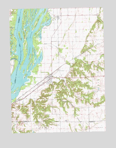
Lomax, IL USGS Topographic Map
Click on map above to begin viewing in our Map Viewer.

This topographic map contains these locations and features:
Feature Name Type Latitude Longitude GNIS ID View Map
Beaver IslandIslandN40.7195°W91.1099°404062View Map
Brush LakeLakeN40.7412°W91.0707°405042View Map
Burlington IslandIslandN40.7292°W91.1038°405232View Map
CarmanPopulated PlaceN40.7406°W91.0596°405610View Map
Carman CemeteryCemeteryN40.7445°W91.0562°1968242View Map
Carman Post OfficePost OfficeN40.7400°W91.0599°1812516View Map
Clear LakeLakeN40.7231°W91.0840°406222View Map
Clifford IslandIslandN40.7245°W91.1065°406251View Map
Clover CemeteryCemeteryN40.7123°W91.0693°406266View Map
Craigel IslandIslandN40.7487°W91.1038°406724View Map
Craigel SloughLakeN40.7425°W91.1053°406725View Map
Crane CemeteryCemeteryN40.6817°W91.0485°1968243View Map
Dallas City Rural Fire Protection District Lomax StationBuildingN40.6787°W91.0726°2640621View Map
Dollar IslandIslandN40.7012°W91.1179°455947View Map
Dugout CreekStreamN40.6864°W91.0979°407468View Map
Enterprise School (historical)SchoolN40.6364°W91.1099°1719535View Map
Fish LakeLakeN40.7356°W91.1024°408388View Map
Freeland CemeteryCemeteryN40.6948°W91.0410°408724View Map
Gittings CemeteryCemeteryN40.6323°W91.0796°409042View Map
Gittings MoundSummitN40.6367°W91.0504°409043View Map
Gittings Mound CemeteryCemeteryN40.6350°W91.0451°1983949View Map
Goose LakeLakeN40.7233°W91.0923°409172View Map
Goose PondLakeN40.6917°W91.0985°1719538View Map
Honey CreekStreamN40.7253°W91.0871°410476View Map
Honey Creek BarBarN40.7073°W91.0946°410479View Map
Iowa JunctionPopulated PlaceN40.6873°W91.0601°422840View Map
Johnson Farm Airport (historical)AirportN40.7262°W91.0699°427109View Map
KemperPopulated PlaceN40.7439°W91.1235°464319View Map
Kemper (historical)LocaleN40.7439°W91.1235°1994905View Map
La Harpe ReservoirReservoirN40.6250°W91.0368°1691250View Map
La Harpe Reservoir DamDamN40.6250°W91.0368°1691249View Map
Little Dugout CreekStreamN40.6770°W91.0540°412330View Map
LomaxPopulated PlaceN40.6789°W91.0729°412529View Map
Lomax Ambulance ServiceBuildingN40.6796°W91.0742°2673858View Map
Lomax Post OfficePost OfficeN40.6807°W91.0729°2788582View Map
Lower CutoffChannelN40.7245°W91.1040°412713View Map
Magee LakeLakeN40.7074°W91.1211°458732View Map
Maple IslandIslandN40.6871°W91.1076°2747131View Map
Millman LakeLakeN40.7344°W91.0784°413618View Map
Millville School (historical)SchoolN40.6962°W91.0418°1719549View Map
Paddy IslandIslandN40.7014°W91.0985°415292View Map
Pin Oak PointCapeN40.7384°W91.0954°1719551View Map
Pleasant Grove School (historical)SchoolN40.6570°W91.0510°1719552View Map
Roscum PondLakeN40.7203°W91.1247°460784View Map
Shaw CemeteryCemeteryN40.6548°W91.0962°1719555View Map
Shok BarBarN40.7481°W91.0776°418454View Map
ShokokonPopulated PlaceN40.7475°W91.0743°418455View Map
Shokokon SloughGutN40.7267°W91.0951°418456View Map
Silver CreekStreamN40.6587°W91.1243°418500View Map
Skunk RiverStreamN40.6978°W91.1151°461664View Map
Skunk SloughStreamN40.7042°W91.1168°461665View Map
Spring CreekStreamN40.7345°W91.1176°461879View Map
Sullivan SloughStreamN40.7312°W91.1182°462070View Map
Sullivan Slough Mississippi River AccessLocaleN40.7303°W91.1224°1994907View Map
Talbert Family CemeteryCemeteryN40.7487°W91.1224°1995141View Map
The SwampsLakeN40.7000°W91.0851°419645View Map
Tiwappity School (historical)SchoolN40.6592°W91.1040°1719571View Map
Township of LomaxCivilN40.6743°W91.0776°429275View Map
Turkey ChuteGutN40.6850°W91.1015°419923View Map
Turkey IslandIslandN40.6823°W91.1060°419933View Map
Twomile IslandIslandN40.7356°W91.0888°419996View Map
Upper Twin IslandIslandN40.7109°W91.1179°462500View Map
Vaughn Lake (historical)LakeN40.7264°W91.0521°1719576View Map
Village of LomaxCivilN40.6789°W91.0762°2398467View Map
Weaver BranchStreamN40.6753°W91.1071°420672View Map
Willow BarBarN40.7228°W91.1121°421223View Map
Yellow BanksPopulated PlaceN40.7303°W91.0813°421567View Map

Note: Coordinates in the location and feature list above are referenced to NAD83 datum.


Copyright (C) 2008-2024 Ryan Niemi / Sunset Dynamics ... All Rights Reserved