TopoQuest Logo
Do you find TopoQuest useful?
Help keep TopoQuest running and adding new maps/features by donating!
Bitcoin:  19c7KJd3qBynnjoSw5npx9KScwjBe4ifkT
Litecoin:  LXs6TkuXGGXo1vDsWCkWVdjQX94eUKd6ui
Home View Maps Find Maps Find Places Resources & Links


Danville, Alabama Topographic Map

USGS Map Title: Danville, AL
USGS Map MRC: 34087D1
DRG (GeoTIFF) Download: o34087d1.tif


Neighboring USGS Topographic Map Quads:


  Caddo, AL  
34087E2
 

  Trinity, AL  
34087E1
 

  Decatur, AL  
34086E8
 

  Oakville, AL  
34087D2
 

  Danville, AL  
34087D1
 

  Hartselle, AL  
34086D8
 

  Upshaw, AL  
34087C2
 

  Massey, AL  
34087C1
 

  Falkville, AL  
34086C8


Map MRC Location:

N35°
W88°
N35°
W87°
H8 H7 H6 H5 H4 H3 H2 H1
G8 G7 G6 G5 G4 G3 G2 G1
F8 F7 F6 F5 F4 F3 F2 F1
E8 E7 E6 E5 E4 E3 E2 E1
D8 D7 D6 D5 D4 D3 D2 D1
C8 C7 C6 C5 C4 C3 C2 C1
B8 B7 B6 B5 B4 B3 B2 B1
A8 A7 A6 A5 A4 A3 A2 A1
N34°
W88°
N34°
W87°

Danville, AL USGS 1:24K Topographic Map Preview:
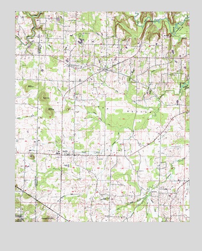
Danville, AL USGS Topographic Map
Click on map above to begin viewing in our Map Viewer.

This topographic map contains these locations and features:
Feature Name Type Latitude Longitude GNIS ID View Map
Alabama Sheriffs Boys RanchLocaleN34.4862°W87.0786°162052View Map
Bald KnobSummitN34.4484°W87.1056°159105View Map
Blowing SpringSpringN34.4853°W87.0133°159203View Map
Cedar MountainSummitN34.3887°W87.0589°159350View Map
Cedar Mountain School (historical)SchoolN34.3904°W87.0575°162055View Map
Cedar Plains Post Office (historical)Post OfficeN34.3779°W87.0111°166097View Map
Cooper CemeteryCemeteryN34.4240°W87.1228°159444View Map
Crawford CreekStreamN34.4909°W87.0339°159462View Map
DanvillePopulated PlaceN34.4145°W87.0875°159483View Map
Danville Airport (historical)AirportN34.4245°W87.1203°161284View Map
Danville Baptist ChurchChurchN34.4151°W87.0833°151225View Map
Danville BranchStreamN34.4207°W87.0553°159484View Map
Danville DivisionCivilN34.4133°W87.0544°165910View Map
Danville High SchoolSchoolN34.4159°W87.0947°162057View Map
Danville PondLakeN34.4085°W87.0867°159485View Map
Danville Post OfficePost OfficeN34.4143°W87.0846°166618View Map
Danville Volunteer Fire Department Station 1BuildingN34.4142°W87.0896°2682966View Map
Danville-Neel Recreation AreaParkN34.4179°W87.0920°162058View Map
Fox BranchStreamN34.4904°W87.1111°159622View Map
Friendship MountainSummitN34.3757°W87.1020°159639View Map
Goose PondSwampN34.4836°W87.0069°159685View Map
Goose Pond BranchStreamN34.4851°W87.0078°162059View Map
Gray BranchStreamN34.4968°W87.1131°159691View Map
Harmony Grove ChurchChurchN34.4943°W87.0825°159722View Map
Herrin CemeteryCemeteryN34.3756°W87.0158°159759View Map
Herrin CreekStreamN34.3904°W87.0286°159760View Map
Hopewell Baptist ChurchChurchN34.4051°W87.0370°159801View Map
Iron Mountain Church (historical)ChurchN34.4404°W87.0003°162060View Map
Ironman Baptist ChurchChurchN34.4407°W87.0006°151233View Map
Isabel MountainSummitN34.4415°W87.1017°159852View Map
Johnson CemeteryCemeteryN34.3779°W87.0972°159863View Map
Johnson Chapel CemeteryCemeteryN34.4498°W87.0822°162061View Map
Johnson Chapel CreekStreamN34.4298°W87.0508°159866View Map
Johnson Chapel United Methodist ChurchChurchN34.4518°W87.0833°159865View Map
Johnson School (historical)SchoolN34.4512°W87.0817°162062View Map
Keys CemeteryCemeteryN34.4676°W87.1203°159893View Map
Liberty School (historical)SchoolN34.4918°W87.0900°161965View Map
Long BottomsValleyN34.4448°W87.0206°160000View Map
Means BridgeBridgeN34.4943°W87.0275°160081View Map
Midway SchoolSchoolN34.3945°W87.0564°160092View Map
Molly BranchStreamN34.4504°W87.0461°160124View Map
NeelPopulated PlaceN34.4657°W87.0611°160222View Map
Neel Church of ChristChurchN34.4743°W87.0381°161968View Map
Neel CreekStreamN34.4415°W87.0228°160223View Map
Neel Elementary SchoolSchoolN34.4679°W87.0603°161970View Map
Neel Methodist ChurchChurchN34.4668°W87.0583°161969View Map
Neel Volunteer Fire DepartmentBuildingN34.4677°W87.0603°2682975View Map
O'Neal CemeteryCemeteryN34.4368°W87.0756°163844View Map
Oak Grove School (historical)SchoolN34.4193°W87.0392°161971View Map
Oak Ridge Volunteer Fire Department Station 1BuildingN34.4694°W87.0063°2682824View Map
Orr CemeteryCemeteryN34.4148°W87.0806°160319View Map
Orr CemeteryCemeteryN34.4173°W87.0492°160320View Map
Orr CreekStreamN34.3895°W87.0303°160321View Map
Owen MountainSummitN34.4548°W87.1170°160327View Map
Puckett CemeteryCemeteryN34.4170°W87.1108°160454View Map
Pumpkin CenterPopulated PlaceN34.4676°W87.0867°160456View Map
Pumpkin Center ChurchChurchN34.4687°W87.0861°161974View Map
Punkin Center Volunteer Fire DepartmentBuildingN34.4726°W87.0859°2682884View Map
Reid School (historical)SchoolN34.3809°W87.1106°161860View Map
Roberts CemeteryCemeteryN34.4651°W87.0539°160497View Map
Roberts CemeteryCemeteryN34.4926°W87.1039°160498View Map
Rock Springs Baptist ChurchChurchN34.4629°W87.0145°160517View Map
Rocky Ford BranchStreamN34.4434°W87.0292°160524View Map
Rocky Ford School (historical)SchoolN34.4545°W87.0292°161975View Map
Rovers BranchStreamN34.4476°W87.0886°161976View Map
Shady Grove Baptist ChurchChurchN34.4657°W87.0628°160588View Map
Stovall CemeteryCemeteryN34.4123°W87.0658°160682View Map
Stover BridgeBridgeN34.4843°W87.1167°160684View Map
Stover CemeteryCemeteryN34.4695°W87.1167°161864View Map
Stroup CemeteryCemeteryN34.4684°W87.0864°160689View Map
Teague BridgeBridgeN34.3932°W87.0278°160726View Map
Thompson CemeteryCemeteryN34.4845°W87.0595°161979View Map
Upton ChapelChurchN34.4912°W87.0906°160782View Map
Windes School (historical)SchoolN34.3812°W87.0128°161981View Map
Wolf BranchStreamN34.3895°W87.0311°160863View Map
Zion School (historical)SchoolN34.4037°W87.0742°161982View Map

Note: Coordinates in the location and feature list above are referenced to NAD83 datum.


Copyright (C) 2008-2024 Ryan Niemi / Sunset Dynamics ... All Rights Reserved