TopoQuest Logo
Do you find TopoQuest useful?
Help keep TopoQuest running and adding new maps/features by donating!
Bitcoin:  19c7KJd3qBynnjoSw5npx9KScwjBe4ifkT
Litecoin:  LXs6TkuXGGXo1vDsWCkWVdjQX94eUKd6ui
Home View Maps Find Maps Find Places Resources & Links


Oakville, Alabama Topographic Map

USGS Map Title: Oakville, AL
USGS Map MRC: 34087D2
DRG (GeoTIFF) Download: o34087d2.tif


Neighboring USGS Topographic Map Quads:


  Masterson Mill, AL  
34087E3
 

  Caddo, AL  
34087E2
 

  Trinity, AL  
34087E1
 

  Moulton, AL  
34087D3
 

  Oakville, AL  
34087D2
 

  Danville, AL  
34087D1
 

  Grayson, AL  
34087C3
 

  Upshaw, AL  
34087C2
 

  Massey, AL  
34087C1


Map MRC Location:

N35°
W88°
N35°
W87°
H8 H7 H6 H5 H4 H3 H2 H1
G8 G7 G6 G5 G4 G3 G2 G1
F8 F7 F6 F5 F4 F3 F2 F1
E8 E7 E6 E5 E4 E3 E2 E1
D8 D7 D6 D5 D4 D3 D2 D1
C8 C7 C6 C5 C4 C3 C2 C1
B8 B7 B6 B5 B4 B3 B2 B1
A8 A7 A6 A5 A4 A3 A2 A1
N34°
W88°
N34°
W87°

Oakville, AL USGS 1:24K Topographic Map Preview:
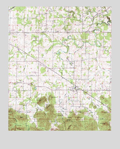
Oakville, AL USGS Topographic Map
Click on map above to begin viewing in our Map Viewer.

This topographic map contains these locations and features:
Feature Name Type Latitude Longitude GNIS ID View Map
Aldridge CemeteryCemeteryN34.3995°W87.2453°159054View Map
Aldridge GrovePopulated PlaceN34.4232°W87.2406°159055View Map
Aldridge Grove Church of ChristChurchN34.4220°W87.2409°161805View Map
Alexander CemeteryCemeteryN34.4012°W87.2322°159056View Map
Alexander CemeteryCemeteryN34.4187°W87.1920°159057View Map
Antioch ChurchChurchN34.4751°W87.1520°159078View Map
Antioch School (historical)SchoolN34.4948°W87.1431°161806View Map
Arbor CemeteryCemeteryN34.3801°W87.1703°159080View Map
Bald Knob ChurchChurchN34.4940°W87.1556°159106View Map
Barnes CemeteryCemeteryN34.4176°W87.1370°159115View Map
Beaver Pond BranchStreamN34.4526°W87.2292°159134View Map
Beech BottomBasinN34.4101°W87.2142°159141View Map
Berea ChurchChurchN34.4954°W87.2006°159150View Map
Big Shoal CreekStreamN34.4834°W87.1364°159185View Map
Brushy MountainSummitN34.4062°W87.2078°159258View Map
Buck BranchStreamN34.4401°W87.1842°159262View Map
Buzzard CoveValleyN34.3826°W87.1931°1729845View Map
Buzzard RoostSummitN34.3873°W87.1667°159288View Map
Camp Ground Church (historical)ChurchN34.3957°W87.1761°161807View Map
Cave Springs School (historical)SchoolN34.4387°W87.2131°161809View Map
Cedar BranchStreamN34.4873°W87.1642°159343View Map
Cedar CreekStreamN34.4987°W87.1839°159345View Map
Cedar Grade HillSummitN34.3901°W87.1983°161810View Map
Cedar MountainSummitN34.4082°W87.1992°159351View Map
Cedar MountainSummitN34.3873°W87.2306°161811View Map
Chestnut RidgeRidgeN34.3884°W87.2367°159388View Map
Cold BranchStreamN34.4629°W87.1892°159423View Map
Cooper CemeteryCemeteryN34.4231°W87.1264°159443View Map
Dement CemeteryCemeteryN34.4987°W87.1917°159495View Map
Echota Cherokee State Designated Tribal Statistical AreaCensusN34.4705°W87.2119°2418564View Map
Elam CreekStreamN34.4632°W87.1864°159564View Map
Enon Baptist ChurchChurchN34.4601°W87.1378°159574View Map
Enon School (historical)SchoolN34.4526°W87.1267°161820View Map
FairfieldPopulated PlaceN34.4743°W87.1931°159584View Map
Fairfield Church (historical)ChurchN34.4745°W87.1922°161821View Map
Fairfield Church of ChristChurchN34.4754°W87.2059°159585View Map
Fairfield School (historical)SchoolN34.4737°W87.2045°161822View Map
Five PointsPopulated PlaceN34.4745°W87.1575°159603View Map
Flat CreekStreamN34.4845°W87.1261°159610View Map
Gibson CemeteryCemeteryN34.4168°W87.1922°159660View Map
Gibson CemeteryCemeteryN34.4281°W87.1822°159661View Map
Gillespie CreekStreamN34.3895°W87.2222°159666View Map
Hampton CemeteryCemeteryN34.3993°W87.1892°159710View Map
Happy HollowValleyN34.4979°W87.1542°159715View Map
Hendon School (historical)SchoolN34.4154°W87.1333°161826View Map
Highway 36 ChurchChurchN34.4195°W87.2147°161828View Map
Hill CemeteryCemeteryN34.4159°W87.1386°159775View Map
Hodges CemeteryCemeteryN34.4659°W87.2186°159781View Map
Hog HeavenSummitN34.3882°W87.1764°159783View Map
Indian Tomb HollowValleyN34.3809°W87.2286°159842View Map
JessetonPopulated PlaceN34.4048°W87.1667°161829View Map
Johnson CemeteryCemeteryN34.3968°W87.1828°159864View Map
Kitchens CemeteryCemeteryN34.4262°W87.1622°159901View Map
Kitchens MillPopulated PlaceN34.4829°W87.1270°161831View Map
Lebanon CemeteryCemeteryN34.4162°W87.1747°159919View Map
Lebanon Church of GodChurchN34.4184°W87.1692°159921View Map
Lee CreekStreamN34.3779°W87.2256°159922View Map
Lindsey BranchStreamN34.4382°W87.1389°159949View Map
Lindsey CemeteryCemeteryN34.4387°W87.1614°159950View Map
Little Shoal CreekStreamN34.4887°W87.1458°159985View Map
McDaniel BridgeBridgeN34.4768°W87.1408°161837View Map
McDaniel CreekStreamN34.4615°W87.1431°160068View Map
McMillan School (historical)SchoolN34.4951°W87.1984°161838View Map
Miller CemeteryCemeteryN34.4095°W87.1808°160108View Map
Miller SpringSpringN34.3990°W87.1833°164244View Map
Millfield MountainSummitN34.3859°W87.2025°161839View Map
Moody CemeteryCemeteryN34.4873°W87.2283°160128View Map
Moulton SpeedwayLocaleN34.4332°W87.2175°161844View Map
Mull MountainSummitN34.3995°W87.1986°160203View Map
OakvillePopulated PlaceN34.4454°W87.1622°160286View Map
Oakville ChurchChurchN34.4407°W87.1706°160287View Map
Oakville PondLakeN34.4460°W87.1769°160288View Map
Oakville Pond BranchStreamN34.4612°W87.1597°160289View Map
Oakville School (historical)SchoolN34.4409°W87.1697°164248View Map
Oakville SpringSpringN34.4432°W87.1722°160290View Map
Old Friendship CemeteryCemeteryN34.3759°W87.1878°160302View Map
Paff CemeteryCemeteryN34.4462°W87.2106°160332View Map
Pine Hill School (historical)SchoolN34.4887°W87.2347°161850View Map
Pinhook MountainSummitN34.3932°W87.2481°161854View Map
Porter HollowValleyN34.3968°W87.1856°160435View Map
Preuit CemeteryCemeteryN34.4068°W87.1883°160444View Map
Red Hill CemeteryCemeteryN34.4768°W87.1817°160476View Map
Red Hill School (historical)SchoolN34.4737°W87.1592°161859View Map
Rocky BranchStreamN34.4698°W87.2053°160522View Map
Rocky BranchStreamN34.4901°W87.1425°160523View Map
Rocky GapGapN34.3909°W87.1900°160525View Map
Sand MountainSummitN34.3820°W87.1317°160559View Map
Sheats BranchStreamN34.4293°W87.1861°160592View Map
Simms CemeteryCemeteryN34.4148°W87.2433°160614View Map
SpeakePopulated PlaceN34.4159°W87.1675°160652View Map
Speake CemeteryCemeteryN34.4198°W87.1689°160653View Map
Speake High SchoolSchoolN34.4184°W87.1692°169335View Map
Speake Volunteer Fire DepartmentBuildingN34.4177°W87.1695°2683006View Map
Speake-Oakville DivisionCivilN34.3807°W87.1667°165844View Map
Stephenson CemeteryCemeteryN34.4290°W87.1386°160672View Map
Stevens HollowValleyN34.3826°W87.2389°160673View Map
Stover BranchStreamN34.4123°W87.1581°160683View Map
Stover CemeteryCemeteryN34.4154°W87.1272°160685View Map
Sugar Camp HollowValleyN34.4001°W87.2147°160690View Map
Tacky BranchStreamN34.4670°W87.1989°161866View Map
Thompson CreekStreamN34.3804°W87.2253°160740View Map
Torrence HillSummitN34.3929°W87.1345°160747View Map
Union Grove ChurchChurchN34.4954°W87.1322°160778View Map
Valley Grove ChurchChurchN34.4201°W87.1692°160785View Map
Wallace Bridge (historical)BridgeN34.4404°W87.1825°1729849View Map
Warren CemeteryCemeteryN34.4148°W87.2333°160801View Map
Washspring MountainSummitN34.3848°W87.1789°160804View Map
Watkins CemeteryCemeteryN34.3884°W87.1853°161868View Map
Watson BranchStreamN34.4890°W87.1703°160807View Map
Watson CemeteryCemeteryN34.4809°W87.1800°160808View Map
Wilborn CemeteryCemeteryN34.4004°W87.2325°160845View Map
Woodard CemeteryCemeteryN34.4106°W87.2431°160868View Map

Note: Coordinates in the location and feature list above are referenced to NAD83 datum.


Copyright (C) 2008-2024 Ryan Niemi / Sunset Dynamics ... All Rights Reserved