TopoQuest Logo
Do you find TopoQuest useful?
Help keep TopoQuest running and adding new maps/features by donating!
Bitcoin:  19c7KJd3qBynnjoSw5npx9KScwjBe4ifkT
Litecoin:  LXs6TkuXGGXo1vDsWCkWVdjQX94eUKd6ui
Home View Maps Find Maps Find Places Resources & Links


Upshaw, Alabama Topographic Map

USGS Map Title: Upshaw, AL
USGS Map MRC: 34087C2
DRG (GeoTIFF) Download: o34087c2.tif


Neighboring USGS Topographic Map Quads:


  Moulton, AL  
34087D3
 

  Oakville, AL  
34087D2
 

  Danville, AL  
34087D1
 

  Grayson, AL  
34087C3
 

  Upshaw, AL  
34087C2
 

  Massey, AL  
34087C1
 

  Houston, AL  
34087B3
 

  Addison, AL  
34087B2
 

  Jones Chapel, AL  
34087B1


Map MRC Location:

N35°
W88°
N35°
W87°
H8 H7 H6 H5 H4 H3 H2 H1
G8 G7 G6 G5 G4 G3 G2 G1
F8 F7 F6 F5 F4 F3 F2 F1
E8 E7 E6 E5 E4 E3 E2 E1
D8 D7 D6 D5 D4 D3 D2 D1
C8 C7 C6 C5 C4 C3 C2 C1
B8 B7 B6 B5 B4 B3 B2 B1
A8 A7 A6 A5 A4 A3 A2 A1
N34°
W88°
N34°
W87°

Upshaw, AL USGS 1:24K Topographic Map Preview:
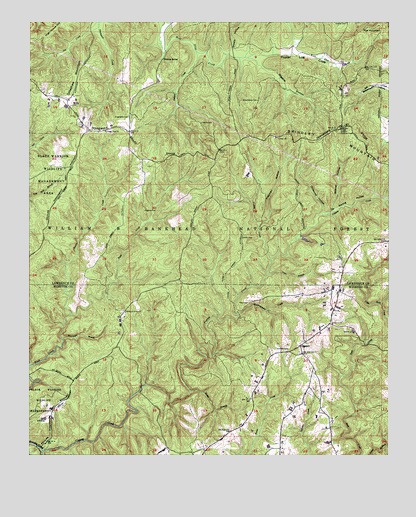
Upshaw, AL USGS Topographic Map
Click on map above to begin viewing in our Map Viewer.

This topographic map contains these locations and features:
Feature Name Type Latitude Longitude GNIS ID View Map
Asherbraner CemeteryCemeteryN34.3526°W87.1706°159090View Map
Blowing SpringSpringN34.3643°W87.2039°159202View Map
Bobcat HollowValleyN34.3218°W87.1442°159220View Map
Brown CreekStreamN34.2904°W87.2350°159252View Map
Capsey CanyonValleyN34.2515°W87.2447°1700527View Map
Capsey CreekStreamN34.2515°W87.2447°159323View Map
Center CemeteryCemeteryN34.3418°W87.1642°1730320View Map
Center ChurchChurchN34.3418°W87.1636°159355View Map
Chitwood HollowValleyN34.3204°W87.1478°159399View Map
Cole BranchStreamN34.3395°W87.2475°161814View Map
Corinth CemeteryCemeteryN34.2803°W87.1597°159449View Map
Dillashaw MountainRidgeN34.3593°W87.2342°159501View Map
Eastern Basham Lookout TowerTowerN34.3448°W87.1422°164321View Map
Fire Tower Number 3 (historical)LocaleN34.3384°W87.1836°164241View Map
Flat MountainSummitN34.3726°W87.1272°159611View Map
Freeman CemeteryCemeteryN34.2664°W87.2106°2701736View Map
Freeman HollowValleyN34.3168°W87.1700°159626View Map
Friendship Baptist Church CemeteryCemeteryN34.2880°W87.1444°2701738View Map
Friendship CemeteryCemeteryN34.3476°W87.2153°159629View Map
Friendship ChurchChurchN34.2882°W87.1447°159637View Map
Friendship Church (historical)ChurchN34.3484°W87.2156°164242View Map
Hickory Grove ChurchChurchN34.2915°W87.2164°159765View Map
Hickory Grove Free Will Baptist Church CemeteryCemeteryN34.2914°W87.2167°2701766View Map
Hickory Grove School (historical)SchoolN34.2911°W87.2175°2680087View Map
Hickory KnobSummitN34.2790°W87.2195°162086View Map
High House HillSummitN34.3745°W87.2400°159770View Map
Hughes CemeteryCemeteryN34.3206°W87.2100°159825View Map
Hurricane BranchStreamN34.2834°W87.2381°159830View Map
Indian CreekStreamN34.3662°W87.1925°159838View Map
Kemp BranchStreamN34.2682°W87.1939°159885View Map
Lindsey Hall ChurchChurchN34.3434°W87.2236°159951View Map
Looneys Tavern (historical)LocaleN34.2503°W87.1925°2680915View Map
Owl Creek Horse CampLocaleN34.3234°W87.2392°163108View Map
Penn BranchStreamN34.3023°W87.1670°160359View Map
Penn CemeteryCemeteryN34.2947°W87.1725°160360View Map
Pool (historical)LocaleN34.3432°W87.2145°161855View Map
Pool KnobSummitN34.3512°W87.2406°161856View Map
Poplar Log CoveValleyN34.3654°W87.1692°160430View Map
Sheats HollowValleyN34.3673°W87.1800°160593View Map
Simms CemeteryCemeteryN34.3748°W87.1397°160613View Map
Smith CemeteryCemeteryN34.3126°W87.1761°160628View Map
Smith CemeteryCemeteryN34.3462°W87.1903°160629View Map
Soakingwater CreekStreamN34.2904°W87.1775°160641View Map
Tar Spring HollowValleyN34.3070°W87.1653°160715View Map
Templeton School (historical)SchoolN34.3415°W87.1761°161867View Map
Turkey CreekStreamN34.2895°W87.1847°162115View Map
Turkey CreekStreamN34.3065°W87.1661°160764View Map
Uby Post Office (historical)Post OfficeN34.2939°W87.2131°167165View Map
UpshawPopulated PlaceN34.2815°W87.1558°160781View Map
Upshaw School (historical)SchoolN34.2805°W87.1561°2680188View Map
Wiggins HollowValleyN34.3634°W87.1711°160843View Map

Note: Coordinates in the location and feature list above are referenced to NAD83 datum.


Copyright (C) 2008-2024 Ryan Niemi / Sunset Dynamics ... All Rights Reserved