TopoQuest Logo
Do you find TopoQuest useful?
Help keep TopoQuest running and adding new maps/features by donating!
Bitcoin:  19c7KJd3qBynnjoSw5npx9KScwjBe4ifkT
Litecoin:  LXs6TkuXGGXo1vDsWCkWVdjQX94eUKd6ui
Home View Maps Find Maps Find Places Resources & Links


Danville NE, Illinois Topographic Map

USGS Map Title: Danville NE, IL
USGS Map MRC: 40087B5
DRG (GeoTIFF) Download: o40087b5.tif


Neighboring USGS Topographic Map Quads:


  Henning, IL  
40087C6
 

  Bismarck, IL  
40087C5
 

  West Lebanon, IN  
40087C4
 

  Danville NW, IL  
40087B6
 

  Danville NE, IL  
40087B5
 

  Covington, IN  
40087B4
 

  Danville SW, IL  
40087A6
 

  Danville SE, IL  
40087A5
 

  Perrysville, IN  
40087A4


Map MRC Location:

N41°
W88°
N41°
W87°
H8 H7 H6 H5 H4 H3 H2 H1
G8 G7 G6 G5 G4 G3 G2 G1
F8 F7 F6 F5 F4 F3 F2 F1
E8 E7 E6 E5 E4 E3 E2 E1
D8 D7 D6 D5 D4 D3 D2 D1
C8 C7 C6 C5 C4 C3 C2 C1
B8 B7 B6 B5 B4 B3 B2 B1
A8 A7 A6 A5 A4 A3 A2 A1
N40°
W88°
N40°
W87°

Danville NE, IL USGS 1:24K Topographic Map Preview:
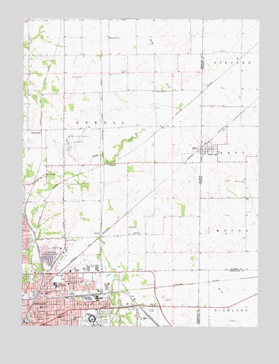
Danville NE, IL USGS Topographic Map
Click on map above to begin viewing in our Map Viewer.

This topographic map contains these locations and features:
Feature Name Type Latitude Longitude GNIS ID View Map
Bible Missionary ChurchChurchN40.1270°W87.6006°2013610View Map
Bowman Avenue Church of GodChurchN40.1281°W87.6120°2013658View Map
Bowman Avenue United Methodist ChurchChurchN40.1398°W87.6114°1823597View Map
Bryley CemeteryCemeteryN40.1828°W87.5956°405078View Map
CampbellPopulated PlaceN40.1911°W87.5795°422526View Map
Cannon Elementary SchoolSchoolN40.1289°W87.6050°405554View Map
Carter Metropolitan Christian Methodist Episcopal ChurchChurchN40.1331°W87.6225°2013659View Map
City of DanvilleCivilN40.1422°W87.6115°2393715View Map
Collett SchoolSchoolN40.1325°W87.6147°406372View Map
Collett Street Church of ChristChurchN40.1289°W87.6167°2013660View Map
Danville Area Community CollegeSchoolN40.1298°W87.5881°406950View Map
Danville Correctional CenterBuildingN40.1310°W87.5364°1823604View Map
Danville Correctional Center HeliportAirportN40.1317°W87.5361°427202View Map
Danville Fire Department Station 3 HeadquartersBuildingN40.1439°W87.6019°2013615View Map
Danville Fire Department Station 4BuildingN40.1319°W87.5961°2013616View Map
Danville National CemeteryCemeteryN40.1271°W87.5801°1823605View Map
East End Church of GodChurchN40.1367°W87.6150°2013618View Map
East Park Church of ChristChurchN40.1459°W87.6036°407682View Map
East Park Elementary SchoolSchoolN40.1414°W87.6056°407683View Map
Elmwood SchoolSchoolN40.1278°W87.5978°407963View Map
Fairchild SchoolSchoolN40.1384°W87.6120°408160View Map
Farmers Chapel CemeteryCemeteryN40.1859°W87.6117°1951034View Map
Farmers Chapel United Methodist ChurchChurchN40.1867°W87.6128°408280View Map
Garfield ParkParkN40.1381°W87.6034°408891View Map
Grange Hall SchoolSchoolN40.2425°W87.5789°409281View Map
Holiday Square Shopping CenterLocaleN40.1486°W87.6072°1823616View Map
Hopewell ChurchChurchN40.1478°W87.5645°410523View Map
Huffman CemeteryCemeteryN40.2280°W87.5733°410656View Map
IllianaPopulated PlaceN40.1964°W87.5320°410753View Map
Immanuel Lutheran ChurchChurchN40.1392°W87.6047°1823619View Map
Immanuel SchoolSchoolN40.1567°W87.6042°410798View Map
Lamb CemeteryCemeteryN40.1653°W87.5689°411774View Map
Latter Day Saints ChurchChurchN40.1600°W87.6017°1719944View Map
Leonard CemeteryCemeteryN40.2262°W87.5985°411952View Map
Lynch CemeteryCemeteryN40.1325°W87.5692°412759View Map
Lynch SchoolSchoolN40.1336°W87.5547°412760View Map
Masonic CemeteryCemeteryN40.1839°W87.5079°439492View Map
McKinley United Methodist ChurchChurchN40.1348°W87.5872°2013669View Map
Meade Airport (historical)AirportN40.1514°W87.5214°449132View Map
Meade ParkParkN40.1309°W87.5820°413340View Map
Meade Park Elementary SchoolSchoolN40.1289°W87.5800°1823632View Map
New Hope ChurchChurchN40.1625°W87.5664°414431View Map
NewellPopulated PlaceN40.1631°W87.5836°423021View Map
North Side Church of the NazareneChurchN40.1381°W87.6125°2013670View Map
Northeast SchoolSchoolN40.1423°W87.6006°414693View Map
Oaklawn Church of the NazareneChurchN40.1339°W87.5884°2013671View Map
Oaklawn SchoolSchoolN40.1325°W87.5822°414909View Map
Second Church of ChristChurchN40.1345°W87.6114°2013647View Map
Springhill CemeteryCemeteryN40.1450°W87.6237°418964View Map
State LinePopulated PlaceN40.1973°W87.5270°449734View Map
State Line City Volunteer Fire DepartmentBuildingN40.1971°W87.5300°2701354View Map
The Israel of God ChurchChurchN40.1284°W87.6181°2013649View Map
Town of State Line CityCivilN40.1973°W87.5271°2397679View Map
Township of NewellCivilN40.2082°W87.5865°429435View Map
Trinity Lutheran ChurchChurchN40.1253°W87.6134°1823643View Map
Trinity SchoolSchoolN40.1256°W87.6128°419875View Map
Union Baptist ChurchChurchN40.1331°W87.6236°2013651View Map
Vacetta Plaza Industrial ParkLocaleN40.1370°W87.6231°2013653View Map
Vermilion Regional AirportAirportN40.1991°W87.6003°427199View Map
Walnut Corner CemeteryCemeteryN40.2217°W87.5547°1951149View Map
Walnut Corner Church of ChristChurchN40.2206°W87.5550°420440View Map
WalzPopulated PlaceN40.1367°W87.5670°423285View Map
West NewellPopulated PlaceN40.2034°W87.6153°423299View Map

Note: Coordinates in the location and feature list above are referenced to NAD83 datum.


Copyright (C) 2008-2024 Ryan Niemi / Sunset Dynamics ... All Rights Reserved