TopoQuest Logo
Do you find TopoQuest useful?
Help keep TopoQuest running and adding new maps/features by donating!
Bitcoin:  19c7KJd3qBynnjoSw5npx9KScwjBe4ifkT
Litecoin:  LXs6TkuXGGXo1vDsWCkWVdjQX94eUKd6ui
Home View Maps Find Maps Find Places Resources & Links


Darby, Montana Topographic Map

USGS Map Title: Darby, MT
USGS Map MRC: 46114A2
DRG (GeoTIFF) Download: o46114a2.tif


Neighboring USGS Topographic Map Quads:


  Ward Mountain, MT  
46114B3
 

  Hamilton South, MT  
46114B2
 

  Mountain House, MT  
46114B1
 

  Como Peaks, MT  
46114A3
 

  Darby, MT  
46114A2
 

  Deer Mountain, MT  
46114A1
 

  Trapper Peak, MT  
45114H3
 

  Burnt Ridge, MT  
45114H2
 

  Robbins Gulch, MT  
45114H1


Map MRC Location:

N47°
W115°
N47°
W114°
H8 H7 H6 H5 H4 H3 H2 H1
G8 G7 G6 G5 G4 G3 G2 G1
F8 F7 F6 F5 F4 F3 F2 F1
E8 E7 E6 E5 E4 E3 E2 E1
D8 D7 D6 D5 D4 D3 D2 D1
C8 C7 C6 C5 C4 C3 C2 C1
B8 B7 B6 B5 B4 B3 B2 B1
A8 A7 A6 A5 A4 A3 A2 A1
N46°
W115°
N46°
W114°

Darby, MT USGS 1:24K Topographic Map Preview:
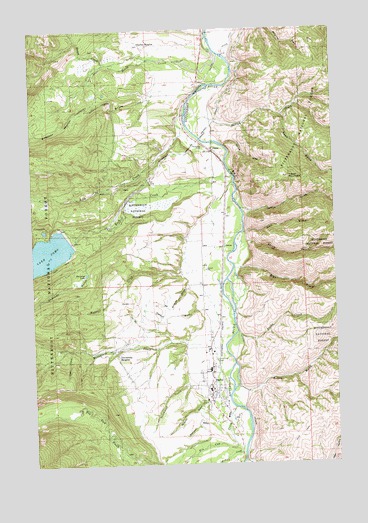
Darby, MT USGS Topographic Map
Click on map above to begin viewing in our Map Viewer.

This topographic map contains these locations and features:
Feature Name Type Latitude Longitude GNIS ID View Map
03N21W10DADD01 WellWellN46.0263°W114.1812°813797View Map
03N21W14BBDA01 WellWellN46.0205°W114.1762°813774View Map
03N21W14CAAA01 WellWellN46.0152°W114.1709°813763View Map
03N21W15CCCD01 WellWellN46.0088°W114.1993°813748View Map
03N21W22BDA_01 WellWellN46.0033°W114.1920°813740View Map
04N21W14CBAD01 WellWellN46.1013°W114.1765°814004View Map
04N21W16DDDD01 WellWellN46.0963°W114.2018°813982View Map
04N21W17BCBB01 WellWellN46.1055°W114.2340°814023View Map
04N21W28DDDD01 WellWellN46.0666°W114.2015°813898View Map
04N21W30DCDD01 WellWellN46.0669°W114.2487°813900View Map
04N21W32BDAA01 WellWellN46.0616°W114.2334°813885View Map
04N21W33AADA01 WellWellN46.0638°W114.2029°813889View Map
04N21W35CCBA01 WellWellN46.0546°W114.1795°813868View Map
Bean (historical)LocaleN46.0777°W114.1704°1803205View Map
Bike Hostel Recreation SiteLocaleN46.0616°W114.1734°794471View Map
Bitterroot River BridgeBridgeN46.0924°W114.1756°1803010View Map
Blacktail GulchValleyN46.0116°W114.1756°780067View Map
Boulanger FieldAirportN46.0306°W114.1853°2770378View Map
Bunkhouse CreekStreamN46.0346°W114.1820°780607View Map
Burke GulchValleyN46.0208°W114.1631°780617View Map
Clear CreekStreamN46.0330°W114.2356°781348View Map
Community Christian SchoolSchoolN46.0224°W114.1793°1803236View Map
ComoPopulated PlaceN46.0896°W114.1754°781547View Map
Como (historical)LocaleN46.0896°W114.1754°1803160View Map
Como Lake DamDamN46.0649°W114.2376°795597View Map
Como Post Office (historical)Post OfficeN46.0896°W114.1754°1803161View Map
Como School (historical)SchoolN46.0908°W114.1756°1803162View Map
DarbyLocaleN46.0216°W114.1731°1803098View Map
DarbyPopulated PlaceN46.0227°W114.1781°782081View Map
Darby AmbulanceBuildingN46.0213°W114.1773°2637861View Map
Darby DivisionCivilN46.0259°W114.2393°1940596View Map
Darby Elementary SchoolSchoolN46.0274°W114.1781°1803242View Map
Darby High SchoolSchoolN46.0274°W114.1781°1803243View Map
Darby ParkParkN46.0227°W114.1781°1803169View Map
Darby Police DepartmentBuildingN46.0206°W114.1778°2548929View Map
Darby Post OfficePost OfficeN46.0235°W114.1783°1803097View Map
Darby Public LibraryBuildingN46.0227°W114.1781°1803005View Map
Darby Volunteer Fire DepartmentBuildingN46.0238°W114.1775°2546544View Map
Dick GulchValleyN46.0666°W114.1629°782368View Map
Durland Park CampgroundLocaleN46.0908°W114.1795°794479View Map
Family Fellowship ChurchChurchN46.0188°W114.1781°1803149View Map
Fern CreekStreamN46.0030°W114.1651°783356View Map
First Baptist ChurchChurchN46.0224°W114.1793°1803151View Map
Fox FieldAirportN46.0959°W114.1807°2650695View Map
GorusPopulated PlaceN46.0627°W114.1720°784131View Map
Gorus GulchValleyN46.0635°W114.1620°784132View Map
Harlan CreekStreamN46.1046°W114.1851°784552View Map
Historic Forest Service MuseumBuildingN46.0227°W114.1781°1803170View Map
Holtet CourtPopulated PlaceN46.0221°W114.1740°1802996View Map
Ike Williams GulchValleyN46.0513°W114.1865°785220View Map
Jerrys GulchValleyN46.0733°W114.1637°785470View Map
Kramis PondLakeN46.0674°W114.2459°793913View Map
Lake Como CampgroundLocaleN46.0677°W114.2495°799081View Map
Lick CreekStreamN46.1005°W114.1870°786098View Map
Lick Creek CampgroundLocaleN46.1041°W114.1870°1803018View Map
Lone Pine CemeteryCemeteryN46.0298°W114.1764°786484View Map
Lost Horse CreekStreamN46.1180°W114.1729°786599View Map
McCarty CreekStreamN46.1133°W114.2004°786997View Map
McQuirk GulchValleyN46.0177°W114.1801°787120View Map
Mike CreekStreamN46.0563°W114.1676°787335View Map
Mister Ts Wildlife MuseumBuildingN46.0227°W114.1781°1803171View Map
Moose CreekStreamN46.1152°W114.2190°787636View Map
Overturf GulchValleyN46.0444°W114.1831°788535View Map
Pioneer MuseumBuildingN46.0227°W114.1781°1803172View Map
Roan GulchValleyN46.0999°W114.1462°789621View Map
Rock CreekStreamN46.0830°W114.1673°789671View Map
Rock Creek Horse CampLocaleN46.0666°W114.2426°1803026View Map
Rock Creek TrailheadLocaleN46.0635°W114.2334°794470View Map
Saint Philip Benizi MissionChurchN46.0216°W114.1745°1803148View Map
Shannon GulchValleyN46.0624°W114.2240°790285View Map
Shannon LakeLakeN46.0549°W114.2286°790286View Map
Southwick CreekStreamN46.0233°W114.1876°791121View Map
Spring GulchValleyN46.0916°W114.1706°791286View Map
Stella CreekStreamN46.0380°W114.1665°791489View Map
Tabor MountainSummitN46.0824°W114.1445°791853View Map
The Church of Jesus Christ of Latter Day SaintsChurchN46.0183°W114.1801°1803150View Map
Tin Cup CreekStreamN46.0163°W114.1681°792207View Map
Tin Cup Creek BridgeBridgeN46.0141°W114.1698°1803011View Map
Town of DarbyCivilN46.0235°W114.1790°2412404View Map
University HeightsPopulated PlaceN46.0335°W114.2156°792595View Map
Upper Como CampgroundLocaleN46.0666°W114.2426°1803027View Map
Waddell CreekStreamN46.0552°W114.1854°792739View Map
Wallace Crawford Memorial Fishing Access SiteLocaleN46.0908°W114.1762°1744448View Map

Note: Coordinates in the location and feature list above are referenced to NAD83 datum.


Copyright (C) 2008-2025 Ryan Niemi / Sunset Dynamics ... All Rights Reserved