TopoQuest Logo
Do you find TopoQuest useful?
Help keep TopoQuest running and adding new maps/features by donating!
Bitcoin:  19c7KJd3qBynnjoSw5npx9KScwjBe4ifkT
Litecoin:  LXs6TkuXGGXo1vDsWCkWVdjQX94eUKd6ui
Home View Maps Find Maps Find Places Resources & Links


Darbyville, Ohio Topographic Map

USGS Map Title: Darbyville, OH
USGS Map MRC: 39083F1
DRG (GeoTIFF) Download: o39083f1.tif


Neighboring USGS Topographic Map Quads:


  Harrisburg, OH  
39083G2
 

  Commercial Point, OH  
39083G1
 

  Lockbourne, OH  
39082G8
 

  Five Points, OH  
39083F2
 

  Darbyville, OH  
39083F1
 

  Ashville, OH  
39082F8
 

  Clarksburg, OH  
39083E2
 

  Williamsport, OH  
39083E1
 

  Circleville, OH  
39082E8


Map MRC Location:

N40°
W84°
N40°
W83°
H8 H7 H6 H5 H4 H3 H2 H1
G8 G7 G6 G5 G4 G3 G2 G1
F8 F7 F6 F5 F4 F3 F2 F1
E8 E7 E6 E5 E4 E3 E2 E1
D8 D7 D6 D5 D4 D3 D2 D1
C8 C7 C6 C5 C4 C3 C2 C1
B8 B7 B6 B5 B4 B3 B2 B1
A8 A7 A6 A5 A4 A3 A2 A1
N39°
W84°
N39°
W83°

Darbyville, OH USGS 1:24K Topographic Map Preview:
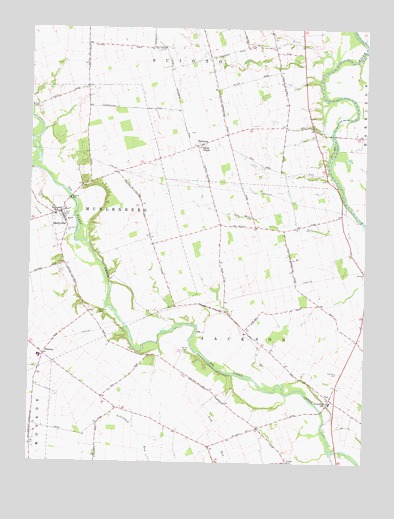
Darbyville, OH USGS Topographic Map
Click on map above to begin viewing in our Map Viewer.

This topographic map contains these locations and features:
Feature Name Type Latitude Longitude GNIS ID View Map
B and D FarmsLocaleN39.6506°W83.0886°2725808View Map
Beckman Field Airport (historical)AirportN39.7428°W83.0386°1082469View Map
Bell School (historical)SchoolN39.6690°W83.0530°1080635View Map
Caldwell School (historical)SchoolN39.6645°W83.0013°1080630View Map
Carvel Manor Mobile Home ParkPopulated PlaceN39.7242°W83.0233°2463213View Map
Clarks Dream StripAirportN39.6428°W83.0152°1082581View Map
Clemmons FarmLocaleN39.6550°W83.0333°2725788View Map
DarbyvillePopulated PlaceN39.6970°W83.1138°1064507View Map
Darbyville CemeteryCemeteryN39.6917°W83.1130°1963368View Map
Darbyville Post Office (historical)Post OfficeN39.6973°W83.1138°2042432View Map
Eagle RunStreamN39.7351°W83.0171°1067174View Map
Florence CemeteryCemeteryN39.6684°W83.0995°1040536View Map
Florence School (historical)SchoolN39.6492°W83.0219°1080629View Map
FoxPopulated PlaceN39.6434°W83.0124°1048755View Map
Fox Post Office (historical)Post OfficeN39.6431°W83.0124°2042435View Map
Foxfield Thoroughbred FarmLocaleN39.6519°W83.0111°2725910View Map
Frogeye School (historical)SchoolN39.6878°W83.0860°1080639View Map
Georges RunStreamN39.7165°W83.1241°1061094View Map
Gochenour School (historical)SchoolN39.7481°W83.0802°1080633View Map
Grave RunStreamN39.7076°W83.0124°1068264View Map
Grove RunStreamN39.7392°W83.0132°1041196View Map
Grove School (historical)SchoolN39.7165°W83.0305°1067748View Map
Gulick CemeteryCemeteryN39.7276°W83.1227°1041210View Map
Herrenstine CemeteryCemeteryN39.6535°W83.0375°1963372View Map
Hill School (historical)SchoolN39.6495°W83.0866°1080640View Map
Huston FarmsLocaleN39.7003°W83.0639°2725802View Map
Jackson Elementary SchoolSchoolN39.6423°W83.0127°1050120View Map
Jackson Township CemeteryCemeteryN39.6509°W83.0091°1963373View Map
Lick Run School (historical)SchoolN39.6320°W83.0649°1080636View Map
Lindsey L S AirportAirportN39.6865°W83.0990°1082580View Map
Lizard RunStreamN39.6956°W83.1082°1070820View Map
Mace FarmsLocaleN39.6733°W83.0161°2725797View Map
PhersonPopulated PlaceN39.6559°W83.1196°1062938View Map
Pherson Post Office (historical)Post OfficeN39.6556°W83.1194°2042440View Map
Pickaway CountyCivilN39.6419°W83.0244°1074077View Map
Pritchard School (historical)SchoolN39.7209°W83.1046°1080638View Map
Redman FarmsLocaleN39.6311°W83.1228°2725916View Map
Renick CemeteryCemeteryN39.6570°W83.0663°1044942View Map
RobtownPopulated PlaceN39.7170°W83.0599°1061617View Map
Robtown Post Office (historical)Post OfficeN39.7167°W83.0596°2042442View Map
Ronshausen AirportAirportN39.6827°W83.0759°1082635View Map
Ruff FarmsLocaleN39.6383°W83.0936°2725793View Map
Schleich School (historical)SchoolN39.6337°W83.1130°1080641View Map
School Number 1 (historical)SchoolN39.6970°W83.0560°1080634View Map
Scioto ChapelChurchN39.7165°W83.0610°1046038View Map
Shadyside School (historical)SchoolN39.7448°W83.1049°1080637View Map
Township of JacksonCivilN39.6469°W83.0383°1086796View Map
Township of MuhlenbergCivilN39.6969°W83.1170°1086799View Map
Van Meter RunStreamN39.6937°W83.0007°1047419View Map
Van Meter School (historical)SchoolN39.6917°W83.0299°1080631View Map
Village of DarbyvilleCivilN39.6956°W83.1139°2398683View Map
Walker School (historical)SchoolN39.7448°W83.0452°1080632View Map
Waycar FarmLocaleN39.6514°W83.0772°2725806View Map
Westfall High SchoolSchoolN39.6553°W83.1213°1050121View Map
White's AirportAirportN39.7053°W83.0976°2442541View Map

Note: Coordinates in the location and feature list above are referenced to NAD83 datum.


Copyright (C) 2008-2025 Ryan Niemi / Sunset Dynamics ... All Rights Reserved