TopoQuest Logo
Do you find TopoQuest useful?
Help keep TopoQuest running and adding new maps/features by donating!
Bitcoin:  19c7KJd3qBynnjoSw5npx9KScwjBe4ifkT
Litecoin:  LXs6TkuXGGXo1vDsWCkWVdjQX94eUKd6ui
Home View Maps Find Maps Find Places Resources & Links


Williamsport, Ohio Topographic Map

USGS Map Title: Williamsport, OH
USGS Map MRC: 39083E1
DRG (GeoTIFF) Download: o39083e1.tif


Neighboring USGS Topographic Map Quads:


  Five Points, OH  
39083F2
 

  Darbyville, OH  
39083F1
 

  Ashville, OH  
39082F8
 

  Clarksburg, OH  
39083E2
 

  Williamsport, OH  
39083E1
 

  Circleville, OH  
39082E8
 

  Frankfort, OH  
39083D2
 

  Andersonville, OH  
39083D1
 

  Kingston, OH  
39082D8


Map MRC Location:

N40°
W84°
N40°
W83°
H8 H7 H6 H5 H4 H3 H2 H1
G8 G7 G6 G5 G4 G3 G2 G1
F8 F7 F6 F5 F4 F3 F2 F1
E8 E7 E6 E5 E4 E3 E2 E1
D8 D7 D6 D5 D4 D3 D2 D1
C8 C7 C6 C5 C4 C3 C2 C1
B8 B7 B6 B5 B4 B3 B2 B1
A8 A7 A6 A5 A4 A3 A2 A1
N39°
W84°
N39°
W83°

Williamsport, OH USGS 1:24K Topographic Map Preview:
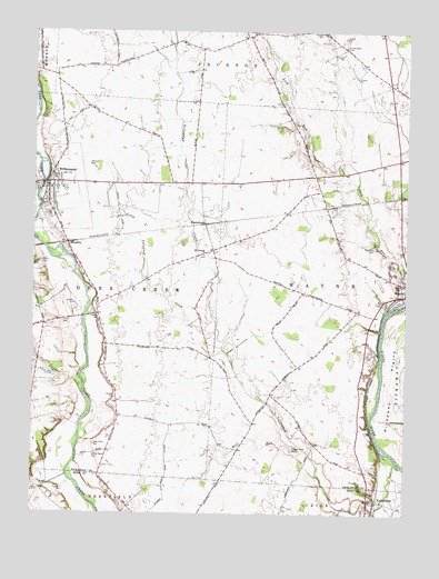
Williamsport, OH USGS Topographic Map
Click on map above to begin viewing in our Map Viewer.

This topographic map contains these locations and features:
Feature Name Type Latitude Longitude GNIS ID View Map
Alkire CemeteryCemeteryN39.5651°W83.1225°1037362View Map
Ater CemeteryCemeteryN39.5057°W83.1233°1963435View Map
Azbell FarmsLocaleN39.6061°W83.1067°2725923View Map
Bazore MillLocaleN39.5506°W83.1085°1069725View Map
Bennett School (historical)SchoolN39.5290°W83.0971°1080620View Map
Chipman CemeteryCemeteryN39.5689°W83.0107°1039074View Map
Christian CemeteryCemeteryN39.5870°W83.1199°1963365View Map
Dungan Farm CemeteryCemeteryN39.5165°W83.0380°1039871View Map
Dungon School (historical)SchoolN39.5326°W83.0432°1080615View Map
Erie CanalCanalN39.5320°W83.0121°1040224View Map
Fugerson School (historical)SchoolN39.5617°W83.0482°1080616View Map
Gray Barn FarmsLocaleN39.5619°W83.0036°2725809View Map
Hanson CemeteryCemeteryN39.5514°W83.1038°1041295View Map
Hoffman FarmsLocaleN39.5672°W83.0028°2725794View Map
Hornbeck School (historical)SchoolN39.5976°W83.0835°1080619View Map
Hulse Farm CemeteryCemeteryN39.6211°W83.0211°1041868View Map
Hulse School (historical)SchoolN39.6203°W83.0207°1080613View Map
J Bar FarmsLocaleN39.5550°W83.0100°2725811View Map
Johnson CemeteryCemeteryN39.5906°W83.1074°1042118View Map
Johnson FarmsLocaleN39.5292°W83.0944°2725918View Map
Keys School (historical)SchoolN39.6198°W83.0866°1080618View Map
KinderhookPopulated PlaceN39.5748°W83.0682°1064939View Map
Kinderhook Post Office (historical)Post OfficeN39.5751°W83.0680°2043422View Map
Methodist CemeteryCemeteryN39.5873°W83.1182°1963380View Map
Mount Pleasant CemeteryCemeteryN39.5670°W83.0680°1963382View Map
Mount Pleasant ChurchChurchN39.5673°W83.0680°1043614View Map
Peck Farm CemeteryCemeteryN39.5179°W83.1045°1044357View Map
Pecks FordCrossingN39.5128°W83.0944°1083207View Map
Rolling H FarmLocaleN39.6200°W83.0519°2725812View Map
School Number 6 (historical)SchoolN39.5673°W83.0688°1080617View Map
Smith Farm CemeteryCemeteryN39.5153°W83.1036°1046379View Map
Township of DeercreekCivilN39.5600°W83.1134°1086794View Map
Township of WayneCivilN39.5622°W83.0233°1086806View Map
Union Grove School (historical)SchoolN39.5859°W83.0305°1080614View Map
Village of WilliamsportCivilN39.5824°W83.1206°2399697View Map
WilliamsportPopulated PlaceN39.5859°W83.1205°1047942View Map
Williamsport and Deercreek Emergency SquadBuildingN39.5840°W83.1192°2550936View Map
Williamsport Church of Christ in Christian UnionChurchN39.5834°W83.1207°1073210View Map
Williamsport Deercreek Township Volunteer Fire DepartmentBuildingN39.5840°W83.1192°2549178View Map
Williamsport Post OfficePost OfficeN39.5862°W83.1207°2042429View Map
Williamsport United Methodist ChurchChurchN39.5870°W83.1185°1073211View Map
WKKJ-FM (Chillicothe)TowerN39.5917°W83.1105°1085328View Map
Wolf RunStreamN39.5162°W83.0338°1048045View Map
WoodlynPopulated PlaceN39.5701°W83.1141°1063101View Map
Woodlyn Post Office (historical)Post OfficeN39.5695°W83.1138°2042448View Map
WWAT-TV (Chillicothe)TowerN39.5917°W83.1105°1085429View Map
Yates CemeteryCemeteryN39.5498°W83.1154°1048181View Map
YellowbudPopulated PlaceN39.5042°W83.0096°1049354View Map
Yellowbud CreekStreamN39.5123°W83.0016°1066548View Map
Yellowbud Post Office (historical)Post OfficeN39.5042°W83.0102°2043392View Map

Note: Coordinates in the location and feature list above are referenced to NAD83 datum.


Copyright (C) 2008-2025 Ryan Niemi / Sunset Dynamics ... All Rights Reserved