TopoQuest Logo
Do you find TopoQuest useful?
Help keep TopoQuest running and adding new maps/features by donating!
Bitcoin:  19c7KJd3qBynnjoSw5npx9KScwjBe4ifkT
Litecoin:  LXs6TkuXGGXo1vDsWCkWVdjQX94eUKd6ui
Home View Maps Find Maps Find Places Resources & Links


Harrisburg, Ohio Topographic Map

USGS Map Title: Harrisburg, OH
USGS Map MRC: 39083G2
DRG (GeoTIFF) Download: o39083g2.tif


Neighboring USGS Topographic Map Quads:


  West Jefferson, OH  
39083H3
 

  Galloway, OH  
39083H2
 

  Southwest Columbus, OH  
39083H1
 

  Big Plain, OH  
39083G3
 

  Harrisburg, OH  
39083G2
 

  Commercial Point, OH  
39083G1
 

  Mount Sterling, OH  
39083F3
 

  Five Points, OH  
39083F2
 

  Darbyville, OH  
39083F1


Map MRC Location:

N40°
W84°
N40°
W83°
H8 H7 H6 H5 H4 H3 H2 H1
G8 G7 G6 G5 G4 G3 G2 G1
F8 F7 F6 F5 F4 F3 F2 F1
E8 E7 E6 E5 E4 E3 E2 E1
D8 D7 D6 D5 D4 D3 D2 D1
C8 C7 C6 C5 C4 C3 C2 C1
B8 B7 B6 B5 B4 B3 B2 B1
A8 A7 A6 A5 A4 A3 A2 A1
N39°
W84°
N39°
W83°

Harrisburg, OH USGS 1:24K Topographic Map Preview:
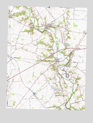
Harrisburg, OH USGS Topographic Map
Click on map above to begin viewing in our Map Viewer.

This topographic map contains these locations and features:
Feature Name Type Latitude Longitude GNIS ID View Map
Battelle Darby Creek Metropolitan ParkParkN39.8748°W83.2155°1080461View Map
Circle S FarmsLocaleN39.8578°W83.2461°2556749View Map
Clark Lakes Pond OneReservoirN39.7760°W83.1723°1078624View Map
Clark Lakes Pond One DamDamN39.7751°W83.1699°1078623View Map
Correctional Reception CenterBuildingN39.8015°W83.1484°2722713View Map
Darby Elementary SchoolSchoolN39.7653°W83.2030°1050125View Map
DarbydalePopulated PlaceN39.8537°W83.1830°1048650View Map
Darbydale Census Designated PlaceCensusN39.8545°W83.1795°2628882View Map
Darbydale Church of the NazareneChurchN39.8534°W83.1841°1067611View Map
Darbydale Elementary SchoolSchoolN39.8540°W83.1855°1060009View Map
Darbydale Post Office (historical)Post OfficeN39.8542°W83.1832°1985727View Map
DerbyPopulated PlaceN39.7687°W83.2057°1064533View Map
Derby Census Designated PlaceCensusN39.7640°W83.2068°2628883View Map
Derby Post OfficePost OfficeN39.7681°W83.2055°2042425View Map
Fitzgerald CemeteryCemeteryN39.8134°W83.2496°1040473View Map
Gay RunStreamN39.8234°W83.1696°1040801View Map
Green Hill ChurchChurchN39.8440°W83.2130°1041097View Map
Green LakeReservoirN39.7740°W83.1268°1078620View Map
Green Lake DamDamN39.7717°W83.1282°1078619View Map
HarrisburgPopulated PlaceN39.8095°W83.1710°1064801View Map
Harrisburg Elementary SchoolSchoolN39.8098°W83.1671°1060008View Map
Harrisburg Post OfficePost OfficeN39.8098°W83.1707°1985473View Map
Harrisburg United Methodist ChurchChurchN39.8126°W83.1707°1067618View Map
Harrisburg Village HallBuildingN39.8108°W83.1711°2125906View Map
Hellbranch RunStreamN39.8215°W83.1685°1066745View Map
Horn Thoroughbred FarmLocaleN39.8407°W83.2407°2730007View Map
Interchange 94CrossingN39.8248°W83.1382°1060006View Map
Little Pennsylvania CemeteryCemeteryN39.8502°W83.2014°1042633View Map
McKinley BridgeBridgeN39.8490°W83.1882°1043079View Map
Miller School (historical)SchoolN39.8237°W83.1430°1060007View Map
Millers (historical)Populated PlaceN39.8251°W83.1444°1806778View Map
OrientPopulated PlaceN39.8046°W83.1530°1065214View Map
Orient Census Designated PlaceCensusN39.8056°W83.1528°2771741View Map
Orient Feeble Minded Institute CemeteryCemeteryN39.7970°W83.1542°1963384View Map
Orient Post OfficePost OfficeN39.8028°W83.1513°2042427View Map
Orient State InstituteSchoolN39.7942°W83.1535°1065215View Map
Orient Town HallBuildingN39.8053°W83.1550°2126005View Map
Pennsylvania School (historical)SchoolN39.8545°W83.1819°1060013View Map
Pickaway Correctional InstitutionBuildingN39.7984°W83.1560°2722720View Map
Pisgah School (historical)SchoolN39.8484°W83.1588°1060005View Map
Pleasant CornersPopulated PlaceN39.8440°W83.1269°1049089View Map
Pleasant Corners Post Office (historical)Post OfficeN39.8445°W83.1263°1987933View Map
Pleasant Township Fire Department Station 231BuildingN39.8565°W83.1819°2549395View Map
Pleasant View High SchoolSchoolN39.8737°W83.1838°1044627View Map
Port-O-John AirportAirportN39.7930°W83.2283°2442509View Map
Snake IslandIslandN39.7856°W83.1441°1046394View Map
Springwater RunStreamN39.8048°W83.1657°1046600View Map
Sunset Hill Estate LakeReservoirN39.7874°W83.1738°1078622View Map
Sunset Hill Estate Lake DamDamN39.7851°W83.1716°1078621View Map
Timber LakeReservoirN39.8298°W83.1552°1078913View Map
Timber Lake DamDamN39.8301°W83.1582°1078912View Map
Township of DarbyCivilN39.7601°W83.1993°1086793View Map
Township of PleasantCivilN39.8582°W83.1889°1086112View Map
Tri - County Joint Fire District Station 492BuildingN39.7738°W83.1677°2550314View Map
Village of HarrisburgCivilN39.8107°W83.1684°2398252View Map
Village of Orient (historical)CivilN39.8053°W83.1521°2399583View Map
Wagon Wheel Mobile Home ParkPopulated PlaceN39.7536°W83.2406°2630808View Map
Wrightsville Post Office (historical)Post OfficeN39.8612°W83.2471°2030260View Map
WrightvillePopulated PlaceN39.8609°W83.2477°1049348View Map

Note: Coordinates in the location and feature list above are referenced to NAD83 datum.


Copyright (C) 2008-2024 Ryan Niemi / Sunset Dynamics ... All Rights Reserved