TopoQuest Logo
Do you find TopoQuest useful?
Help keep TopoQuest running and adding new maps/features by donating!
Bitcoin:  19c7KJd3qBynnjoSw5npx9KScwjBe4ifkT
Litecoin:  LXs6TkuXGGXo1vDsWCkWVdjQX94eUKd6ui
Home View Maps Find Maps Find Places Resources & Links


Darst Creek, Texas Topographic Map

USGS Map Title: Darst Creek, TX
USGS Map MRC: 29097E7
DRG (GeoTIFF) Download: o29097e7.tif


Neighboring USGS Topographic Map Quads:


  Geronimo, TX  
29097F8
 

  Kingsbury, TX  
29097F7
 

  Luling, TX  
29097F6
 

  Seguin, TX  
29097E8
 

  Darst Creek, TX  
29097E7
 

  Belmont, TX  
29097E6
 

  Thomas Springs, TX  
29097D8
 

  Dewville, TX  
29097D7
 

  Leesville, TX  
29097D6


Map MRC Location:

N30°
W98°
N30°
W97°
H8 H7 H6 H5 H4 H3 H2 H1
G8 G7 G6 G5 G4 G3 G2 G1
F8 F7 F6 F5 F4 F3 F2 F1
E8 E7 E6 E5 E4 E3 E2 E1
D8 D7 D6 D5 D4 D3 D2 D1
C8 C7 C6 C5 C4 C3 C2 C1
B8 B7 B6 B5 B4 B3 B2 B1
A8 A7 A6 A5 A4 A3 A2 A1
N29°
W98°
N29°
W97°

Darst Creek, TX USGS 1:24K Topographic Map Preview:
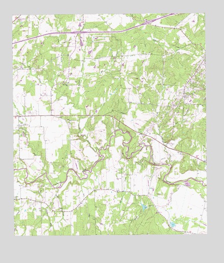
Darst Creek, TX USGS Topographic Map
Click on map above to begin viewing in our Map Viewer.

This topographic map contains these locations and features:
Feature Name Type Latitude Longitude GNIS ID View Map
Bishop LakeReservoirN29.5058°W97.7726°1857394View Map
Bishop Lake DamDamN29.5052°W97.7736°1857393View Map
Brenner CemeteryCemeteryN29.5155°W97.8436°1331226View Map
Capote ChurchChurchN29.5252°W97.8089°1332134View Map
Cordell CreekStreamN29.5288°W97.8506°1333347View Map
Darst CreekStreamN29.5400°W97.7747°1334053View Map
Darst Oil FieldOilfieldN29.5938°W97.7517°1334054View Map
Deer CreekStreamN29.5580°W97.7806°1334206View Map
Eden CemeteryCemeteryN29.5622°W97.8711°1335083View Map
Glen Beicker Ranch Airport (historical)AirportN29.5294°W97.7883°1387525View Map
Holmes LakeReservoirN29.5158°W97.7908°1857392View Map
Holmes Lake DamDamN29.5152°W97.7886°1857391View Map
Jahns CemeteryCemeteryN29.5413°W97.7944°1338617View Map
Lackorn AirportAirportN29.5361°W97.8338°1387523View Map
Long BranchStreamN29.5875°W97.8506°1340430View Map
Matthies CemeteryCemeteryN29.5230°W97.7822°1341079View Map
Mill CreekStreamN29.5486°W97.8192°1341621View Map
New Salem Baptist ChurchChurchN29.5872°W97.8389°2019498View Map
New Salem ChurchChurchN29.5861°W97.8400°1342510View Map
Polecat CreekStreamN29.5225°W97.8483°1344312View Map
Randolph CreekStreamN29.5747°W97.8333°1344786View Map
Red BranchStreamN29.5855°W97.8317°1344897View Map
Rocky CreekStreamN29.5272°W97.8475°1345454View Map
Salt CreekStreamN29.5322°W97.8286°1346220View Map
Sandy HollowValleyN29.5127°W97.7750°1346599View Map
Saul CreekStreamN29.5358°W97.8542°1346720View Map
Sawlog CreekStreamN29.5416°W97.7872°1346733View Map
Seguin East Division (historical)CensusN29.5338°W97.8144°1939183View Map

Note: Coordinates in the location and feature list above are referenced to NAD83 datum.


Copyright (C) 2008-2025 Ryan Niemi / Sunset Dynamics ... All Rights Reserved