TopoQuest Logo
Do you find TopoQuest useful?
Help keep TopoQuest running and adding new maps/features by donating!
Bitcoin:  19c7KJd3qBynnjoSw5npx9KScwjBe4ifkT
Litecoin:  LXs6TkuXGGXo1vDsWCkWVdjQX94eUKd6ui
Home View Maps Find Maps Find Places Resources & Links


Davenport, Oklahoma Topographic Map

USGS Map Title: Davenport, OK
USGS Map MRC: 35096F7
DRG (GeoTIFF) Download: o35096f7.tif


Neighboring USGS Topographic Map Quads:


  Tryon South, OK  
35096G8
 

  Kendrick, OK  
35096G7
 

  Stroud North, OK  
35096G6
 

  Chandler, OK  
35096F8
 

  Davenport, OK  
35096F7
 

  Stroud South, OK  
35096F6
 

  Meeker, OK  
35096E8
 

  Sparks, OK  
35096E7
 

  Arlington, OK  
35096E6


Map MRC Location:

N36°
W97°
N36°
W96°
H8 H7 H6 H5 H4 H3 H2 H1
G8 G7 G6 G5 G4 G3 G2 G1
F8 F7 F6 F5 F4 F3 F2 F1
E8 E7 E6 E5 E4 E3 E2 E1
D8 D7 D6 D5 D4 D3 D2 D1
C8 C7 C6 C5 C4 C3 C2 C1
B8 B7 B6 B5 B4 B3 B2 B1
A8 A7 A6 A5 A4 A3 A2 A1
N35°
W97°
N35°
W96°

Davenport, OK USGS 1:24K Topographic Map Preview:
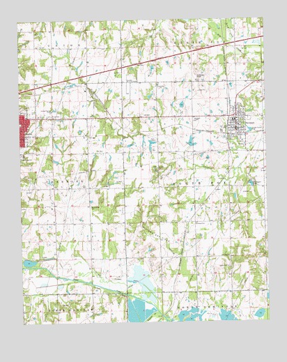
Davenport, OK USGS Topographic Map
Click on map above to begin viewing in our Map Viewer.

This topographic map contains these locations and features:
Feature Name Type Latitude Longitude GNIS ID View Map
A C M DamDamN35.6984°W96.7886°1750803View Map
A C M LakeReservoirN35.6995°W96.7883°1750804View Map
Booker CemeteryCemeteryN35.6478°W96.7703°1090393View Map
Cardwell CemeteryCemeteryN35.6961°W96.8666°1090960View Map
Chandler DivisionCivilN35.6980°W96.8488°1937666View Map
Chandler Fire Department Station 2BuildingN35.7243°W96.8224°2657083View Map
Chandler Regional AirportAirportN35.7245°W96.8218°1102399View Map
ClematisLocaleN35.6478°W96.7689°1763673View Map
DaggettLocaleN35.7017°W96.7870°1763674View Map
DavenportPopulated PlaceN35.7048°W96.7653°1091940View Map
Davenport CemeteryCemeteryN35.7086°W96.7860°2681655View Map
Davenport ChapelChurchN35.7087°W96.7859°1091941View Map
Davenport DamDamN35.6834°W96.7586°1750805View Map
Davenport Elementary SchoolSchoolN35.7083°W96.7668°1790620View Map
Davenport High SchoolSchoolN35.7083°W96.7665°1790313View Map
Davenport LakeReservoirN35.6805°W96.7580°1091943View Map
Davenport Police DepartmentBuildingN35.7054°W96.7649°2757719View Map
Davenport Volunteer Fire DepartmentBuildingN35.7062°W96.7648°2656833View Map
Dunkard CemeteryCemeteryN35.6656°W96.7864°1092302View Map
Gobblers KnobSummitN35.7265°W96.7853°1093230View Map
Kingdom Hall-Jehovahs WitnessChurchN35.7140°W96.8717°1782647View Map
Little Zion ChurchChurchN35.6520°W96.7700°1094871View Map
Morning Star CemeteryCemeteryN35.6731°W96.8398°1095514View Map
New Zion CemeteryCemeteryN35.6893°W96.8057°2681656View Map
New Zion ChapelChurchN35.6887°W96.8050°1095846View Map
Oknoname 08107 DamDamN35.7317°W96.8070°1753013View Map
Oknoname 08107 ReservoirReservoirN35.7300°W96.8073°1753014View Map
Pleasant Hill CemeteryCemeteryN35.6380°W96.7880°2704482View Map
Possum Trot CreekStreamN35.7312°W96.7509°1096857View Map
Quapaw CreekStreamN35.6287°W96.8056°1096983View Map
Ranch CreekStreamN35.7351°W96.7597°1097034View Map
Sac and Fox Oklahoma Tribal Statistical AreaCensusN35.7124°W96.7713°1925067View Map
Town of DavenportCivilN35.7093°W96.7643°2412407View Map
Township of South FoxCivilN35.6820°W96.7697°1824917View Map

Note: Coordinates in the location and feature list above are referenced to NAD83 datum.


Copyright (C) 2008-2024 Ryan Niemi / Sunset Dynamics ... All Rights Reserved