TopoQuest Logo
Do you find TopoQuest useful?
Help keep TopoQuest running and adding new maps/features by donating!
Bitcoin:  19c7KJd3qBynnjoSw5npx9KScwjBe4ifkT
Litecoin:  LXs6TkuXGGXo1vDsWCkWVdjQX94eUKd6ui
Home View Maps Find Maps Find Places Resources & Links


Davy, West Virginia Topographic Map

USGS Map Title: Davy, WV
USGS Map MRC: 37081D6
DRG (GeoTIFF) Download: o37081d6.tif


Neighboring USGS Topographic Map Quads:


  Gilbert, WV  
37081E7
 

  Baileysville, WV  
37081E6
 

  Pineville, WV  
37081E5
 

  Iaeger, WV  
37081D7
 

  Davy, WV  
37081D6
 

  Welch, WV  
37081D5
 

  Bradshaw, WV  
37081C7
 

  War, WV  
37081C6
 

  Gary, WV  
37081C5


Map MRC Location:

N38°
W82°
N38°
W81°
H8 H7 H6 H5 H4 H3 H2 H1
G8 G7 G6 G5 G4 G3 G2 G1
F8 F7 F6 F5 F4 F3 F2 F1
E8 E7 E6 E5 E4 E3 E2 E1
D8 D7 D6 D5 D4 D3 D2 D1
C8 C7 C6 C5 C4 C3 C2 C1
B8 B7 B6 B5 B4 B3 B2 B1
A8 A7 A6 A5 A4 A3 A2 A1
N37°
W82°
N37°
W81°

Davy, WV USGS 1:24K Topographic Map Preview:
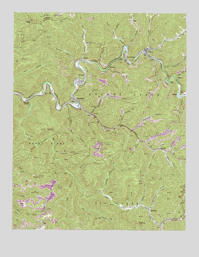
Davy, WV USGS Topographic Map
Click on map above to begin viewing in our Map Viewer.

This topographic map contains these locations and features:
Feature Name Type Latitude Longitude GNIS ID View Map
Abbcamp BranchStreamN37.4198°W81.7204°1534786View Map
Badway BranchStreamN37.4212°W81.6484°1535111View Map
Bee BranchStreamN37.4709°W81.6890°1535470View Map
Big BendBendN37.4621°W81.6376°1535769View Map
Big BranchStreamN37.3946°W81.6976°1535801View Map
Big SandyPopulated PlaceN37.4643°W81.6982°1553902View Map
Big Sandy Census Designated PlaceCensusN37.4608°W81.7049°2586765View Map
Big Sandy Post OfficePost OfficeN37.4593°W81.7027°1689116View Map
Big Sandy Truss BridgeBridgeN37.4598°W81.7041°2647257View Map
Clear ForkStreamN37.4507°W81.7371°1537391View Map
Clear Fork JunctionPopulated PlaceN37.4490°W81.7398°1554144View Map
CoalwoodPopulated PlaceN37.3873°W81.6526°1554166View Map
Coalwood - Caretta Volunteer Fire DepartmentBuildingN37.3881°W81.6533°2577654View Map
Coalwood Community ChurchChurchN37.3882°W81.6515°1689124View Map
Coalwood Lookout TowerTowerN37.3787°W81.6584°1557818View Map
Coalwood Post OfficePost OfficeN37.3871°W81.6526°1689125View Map
Coon BranchStreamN37.3996°W81.7093°1689126View Map
Coontree BranchStreamN37.4273°W81.6584°1537644View Map
Crane Trace BranchStreamN37.4054°W81.7059°1537795View Map
Cub BranchStreamN37.4521°W81.6287°1537890View Map
DavyPopulated PlaceN37.4784°W81.6534°1538061View Map
Davy BranchStreamN37.4771°W81.6551°1538064View Map
Davy Police DepartmentBuildingN37.4762°W81.6532°2728037View Map
Davy Post OfficePost OfficeN37.4782°W81.6537°1689128View Map
Davy Volunteer Fire DepartmentBuildingN37.4762°W81.6532°2577673View Map
Daycamp BranchStreamN37.3973°W81.6862°1538079View Map
ErinPopulated PlaceN37.4415°W81.6926°1554410View Map
Fall River Elementary SchoolSchoolN37.4581°W81.7045°1689135View Map
HensleyPopulated PlaceN37.4740°W81.6998°1554684View Map
Hensley CreekStreamN37.4726°W81.7001°1540169View Map
Hensley KnobSummitN37.4951°W81.7371°1540170View Map
Hensley Post OfficePost OfficeN37.4727°W81.7025°1689144View Map
Honeycamp BranchStreamN37.4323°W81.6634°1540425View Map
Huntingshirt BranchStreamN37.4682°W81.6818°1540604View Map
Iaeger Memorial CemeteryCemeteryN37.4470°W81.7046°1541306View Map
Jenny BranchStreamN37.4693°W81.6423°1540868View Map
Jim BranchStreamN37.3873°W81.6654°1540894View Map
Left Fork Davy BranchStreamN37.4798°W81.6509°1541651View Map
Little Daycamp BranchStreamN37.4351°W81.6729°1542083View Map
Little Jenny BranchStreamN37.4637°W81.6354°1542135View Map
Little Vine ChurchChurchN37.4457°W81.6901°1542251View Map
Long BranchStreamN37.4734°W81.6479°1542336View Map
Lower Hensley CreekStreamN37.4684°W81.7023°1542544View Map
Lower Twin BranchStreamN37.4812°W81.6696°1542584View Map
MarinePopulated PlaceN37.4629°W81.6307°1555047View Map
MarytownPopulated PlaceN37.4698°W81.6796°1555062View Map
McDowell CountyCivilN37.3785°W81.6536°1689162View Map
Meathouse BranchStreamN37.4068°W81.7065°1543100View Map
MoheganPopulated PlaceN37.4532°W81.6307°1555143View Map
Moorecamp BranchStreamN37.4209°W81.6373°1543519View Map
Mudhole BranchStreamN37.3884°W81.6598°1543933View Map
Myrtle Valley ChurchChurchN37.4823°W81.6976°1544033View Map
Newson BranchStreamN37.4198°W81.6396°1544161View Map
Olga Lookout TowerTowerN37.3818°W81.6857°1557875View Map
Olga Number 3 Lookout TowerTowerN37.4332°W81.7251°1557876View Map
PremierPopulated PlaceN37.4223°W81.6437°1555405View Map
Premier Post OfficePost OfficeN37.4212°W81.6387°1689178View Map
River Laurel BranchStreamN37.4473°W81.7123°1545770View Map
RoderfieldPopulated PlaceN37.4504°W81.7057°1555514View Map
Roderfield Census Designated PlaceCensusN37.4501°W81.7029°2586876View Map
Roderfield Post OfficePost OfficeN37.4451°W81.7002°1689182View Map
Roderfield Volunteer Fire DepartmentBuildingN37.4510°W81.7074°2578034View Map
Shabbyroom BranchStreamN37.4415°W81.6940°1546588View Map
Short BranchStreamN37.4598°W81.6373°1689186View Map
Snakeroot BranchStreamN37.3868°W81.6521°1547026View Map
Spice CreekStreamN37.4454°W81.7026°1547135View Map
Spice Laurel BranchStreamN37.4412°W81.6937°1547138View Map
Stonecoal BranchStreamN37.4259°W81.6543°1547464View Map
Town of DavyCivilN37.4758°W81.6475°2390822View Map
Twin BranchStreamN37.4807°W81.6676°1548400View Map
Twin BranchPopulated PlaceN37.4748°W81.6684°1555845View Map
Twin Branch Pentecostal AcademySchoolN37.4757°W81.6686°2088381View Map
Twin Branch Pony Truss Number 1 BridgeBridgeN37.4759°W81.6718°2647258View Map
Twin Branch Post OfficePost OfficeN37.4790°W81.6679°1689200View Map
Twin Branch Truss Number 2 BridgeBridgeN37.4760°W81.6696°2647260View Map
Twin Branch TunnelTunnelN37.4749°W81.6718°2647259View Map
Wolfpen BranchStreamN37.3787°W81.6429°1549321View Map

Note: Coordinates in the location and feature list above are referenced to NAD83 datum.


Copyright (C) 2008-2025 Ryan Niemi / Sunset Dynamics ... All Rights Reserved