TopoQuest Logo
Do you find TopoQuest useful?
Help keep TopoQuest running and adding new maps/features by donating!
Bitcoin:  19c7KJd3qBynnjoSw5npx9KScwjBe4ifkT
Litecoin:  LXs6TkuXGGXo1vDsWCkWVdjQX94eUKd6ui
Home View Maps Find Maps Find Places Resources & Links


Pineville, West Virginia Topographic Map

USGS Map Title: Pineville, WV
USGS Map MRC: 37081E5
DRG (GeoTIFF) Download: o37081e5.tif


Neighboring USGS Topographic Map Quads:


  Oceana, WV  
37081F6
 

  Matheny, WV  
37081F5
 

  McGraws, WV  
37081F4
 

  Baileysville, WV  
37081E6
 

  Pineville, WV  
37081E5
 

  Mullens, WV  
37081E4
 

  Davy, WV  
37081D6
 

  Welch, WV  
37081D5
 

  Keystone, WV  
37081D4


Map MRC Location:

N38°
W82°
N38°
W81°
H8 H7 H6 H5 H4 H3 H2 H1
G8 G7 G6 G5 G4 G3 G2 G1
F8 F7 F6 F5 F4 F3 F2 F1
E8 E7 E6 E5 E4 E3 E2 E1
D8 D7 D6 D5 D4 D3 D2 D1
C8 C7 C6 C5 C4 C3 C2 C1
B8 B7 B6 B5 B4 B3 B2 B1
A8 A7 A6 A5 A4 A3 A2 A1
N37°
W82°
N37°
W81°

Pineville, WV USGS 1:24K Topographic Map Preview:
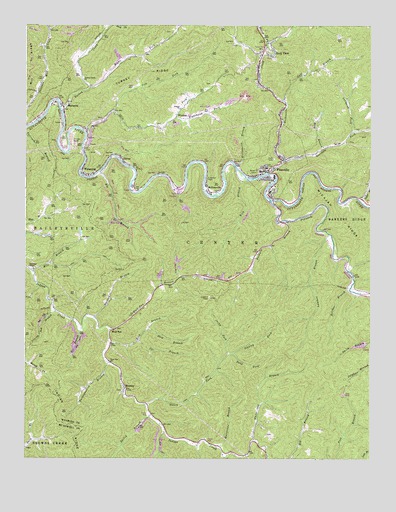
Pineville, WV USGS Topographic Map
Click on map above to begin viewing in our Map Viewer.

This topographic map contains these locations and features:
Feature Name Type Latitude Longitude GNIS ID View Map
Bailey BranchStreamN37.5126°W81.5790°1535116View Map
Baldwin BranchStreamN37.5687°W81.5304°1535168View Map
Bearhole ForkStreamN37.5854°W81.5315°1535413View Map
Bee BranchStreamN37.5365°W81.6048°1535473View Map
Belcher BranchStreamN37.5487°W81.5076°1535584View Map
Big BranchStreamN37.5829°W81.5984°1535783View Map
Bird BranchStreamN37.5896°W81.5168°1536033View Map
Brewster ChapelChurchN37.5554°W81.6234°1536326View Map
Car BranchStreamN37.5340°W81.5840°1537032View Map
Coon ForkStreamN37.6246°W81.5271°1537626View Map
Cooper ChurchChurchN37.6009°W81.5690°1537650View Map
District 2CivilN37.5637°W81.6220°1928225View Map
GloverPopulated PlaceN37.5865°W81.5904°1554576View Map
Gulf BranchStreamN37.6032°W81.5318°1539782View Map
Holy Cross Catholic ChurchChurchN37.5787°W81.5348°1741546View Map
Hurricane BranchStreamN37.5034°W81.5557°1540613View Map
Jacky ForkStreamN37.5301°W81.5518°1540791View Map
Jud BranchStreamN37.5426°W81.6140°1541034View Map
Kee FieldAirportN37.5994°W81.5585°1558836View Map
Keppler Mine ImpoundmentReservoirN37.5751°W81.5665°1559362View Map
Lambert BranchStreamN37.5648°W81.5148°1541324View Map
Lambert Knob Lookout TowerLocaleN37.5465°W81.5584°1741484View Map
Left Fork Skin ForkStreamN37.5996°W81.5934°1541722View Map
Lefthand Fork Bearhole ForkStreamN37.5937°W81.5076°1541761View Map
Lick BranchStreamN37.5337°W81.5943°1541834View Map
Lt. James L Smith Memorial BridgeBridgeN37.5748°W81.5354°2647170View Map
MariannaPopulated PlaceN37.6004°W81.6112°1557996View Map
Marsh ForkStreamN37.6198°W81.5373°1542785View Map
Mile BranchStreamN37.5534°W81.6218°1543265View Map
Mill RidgeRidgeN37.6132°W81.6237°1543345View Map
MullensvillePopulated PlaceN37.5773°W81.5587°1543990View Map
Nancy ForkStreamN37.5159°W81.5812°1544038View Map
Number 50 Earthfill ImpoundmentReservoirN37.5418°W81.5282°1559360View Map
PinevillePopulated PlaceN37.5832°W81.5370°1544914View Map
Pineville Baptist ChurchChurchN37.5862°W81.5320°1741572View Map
Pineville Elementary SchoolSchoolN37.5780°W81.5355°2088312View Map
Pineville High School (historical)SchoolN37.5771°W81.5365°1741573View Map
Pineville Middle SchoolSchoolN37.5771°W81.5365°2088313View Map
Pineville Police DepartmentBuildingN37.5852°W81.5328°2728207View Map
Pineville Post OfficePost OfficeN37.5829°W81.5401°1741501View Map
Pineville Public LibraryBuildingN37.5828°W81.5382°2727399View Map
Pineville Volunteer Fire DepartmentBuildingN37.5828°W81.5374°2577932View Map
Pinnacle CreekStreamN37.5748°W81.5368°1549519View Map
Pinnacle Creek Refuse Bank DamDamN37.5418°W81.5282°1559359View Map
Raccoon BranchStreamN37.5407°W81.6001°1545355View Map
Refuse Dam and Impoundment Number OneDamN37.5751°W81.5665°1559361View Map
Rich BranchStreamN37.5832°W81.5487°1545533View Map
Right Fork Turkey CreekStreamN37.6065°W81.6021°1545719View Map
Righthand Fork Skin ForkStreamN37.5984°W81.5709°1545744View Map
Rock ViewPopulated PlaceN37.6179°W81.5390°1555503View Map
Rockcastle CreekStreamN37.5823°W81.5384°1545956View Map
Shop BranchStreamN37.5376°W81.5804°1546709View Map
Skin ForkStreamN37.5948°W81.6046°1546865View Map
Spence ForkStreamN37.6232°W81.6165°1547123View Map
Stanley ForkStreamN37.5304°W81.5515°1547336View Map
Stat Emergency Medical ServiceBuildingN37.5807°W81.5356°2581072View Map
Sugar RunStreamN37.5746°W81.5037°1547654View Map
Swag ForkStreamN37.5304°W81.5498°1547784View Map
Swope Farm Airport (historical)AirportN37.5665°W81.6171°1558794View Map
Town of PinevilleCivilN37.5848°W81.5355°2391362View Map
Turkey CreekStreamN37.6007°W81.6123°1548333View Map
Turkey Creek ChurchChurchN37.6093°W81.6043°1548335View Map
Turkey RidgeRidgeN37.6118°W81.5851°1548349View Map
Turkeywallow BranchStreamN37.5279°W81.5946°1548375View Map
White Oak BranchStreamN37.5059°W81.5420°1549034View Map
Williamson BranchStreamN37.5837°W81.5487°1549186View Map
WindomPopulated PlaceN37.5987°W81.5704°1556004View Map
Wolf PenLocaleN37.5379°W81.5918°1549280View Map
Wolf Pen BranchStreamN37.5373°W81.5946°1549281View Map
Wolf Pen ChurchChurchN37.5276°W81.5937°1549282View Map
Wolf Pen Post OfficePost OfficeN37.5371°W81.5937°1741519View Map
WoosleyPopulated PlaceN37.5204°W81.5884°1549397View Map
WWYO-AM (Pineville)TowerN37.5890°W81.5401°1559736View Map
WyomingPopulated PlaceN37.5823°W81.6018°1556034View Map
Wyoming CountyCivilN37.6096°W81.5492°1550061View Map
Wyoming County Career and Technical CenterSchoolN37.5911°W81.5124°2088413View Map
Wyoming County CourthouseBuildingN37.5840°W81.5367°1741582View Map
Wyoming County Sheriff's OfficeBuildingN37.5840°W81.5377°2728206View Map
Wyoming Post OfficePost OfficeN37.5820°W81.6005°1741523View Map

Note: Coordinates in the location and feature list above are referenced to NAD83 datum.


Copyright (C) 2008-2025 Ryan Niemi / Sunset Dynamics ... All Rights Reserved