TopoQuest Logo
Do you find TopoQuest useful?
Help keep TopoQuest running and adding new maps/features by donating!
Bitcoin:  19c7KJd3qBynnjoSw5npx9KScwjBe4ifkT
Litecoin:  LXs6TkuXGGXo1vDsWCkWVdjQX94eUKd6ui
Home View Maps Find Maps Find Places Resources & Links


Acton, California Topographic Map

USGS Map Title: Acton, CA
USGS Map MRC: 34118D2
DRG (GeoTIFF) Download: o34118d2.tif


Neighboring USGS Topographic Map Quads:


  Sleepy Valley, CA  
34118E3
 

  Ritter Ridge, CA  
34118E2
 

  Palmdale, CA  
34118E1
 

  Agua Dulce, CA  
34118D3
 

  Acton, CA  
34118D2
 

  Pacifico Mountain, CA  
34118D1
 

  Sunland, CA  
34118C3
 

  Condor Peak, CA  
34118C2
 

  Chilao Flat, CA  
34118C1


Map MRC Location:

N35°
W119°
N35°
W118°
H8 H7 H6 H5 H4 H3 H2 H1
G8 G7 G6 G5 G4 G3 G2 G1
F8 F7 F6 F5 F4 F3 F2 F1
E8 E7 E6 E5 E4 E3 E2 E1
D8 D7 D6 D5 D4 D3 D2 D1
C8 C7 C6 C5 C4 C3 C2 C1
B8 B7 B6 B5 B4 B3 B2 B1
A8 A7 A6 A5 A4 A3 A2 A1
N34°
W119°
N34°
W118°

Acton, CA USGS 1:24K Topographic Map Preview:
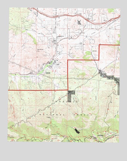
Acton, CA USGS Topographic Map
Click on map above to begin viewing in our Map Viewer.

This topographic map contains these locations and features:
Feature Name Type Latitude Longitude GNIS ID View Map
ActonPopulated PlaceN34.4700°W118.1967°1660228View Map
Acton CampLocaleN34.4500°W118.1981°238405View Map
Acton CanyonValleyN34.4739°W118.1995°269428View Map
Acton Census Designated PlaceCensusN34.4956°W118.1858°2407697View Map
Acton Community CemeteryCemeteryN34.4806°W118.2022°238406View Map
Acton Community Presbyterian ChurchChurchN34.4711°W118.1969°2104934View Map
Acton Elementary SchoolSchoolN34.4728°W118.1965°249652View Map
Acton Foursquare Christian ChurchChurchN34.4683°W118.2022°2104933View Map
Acton Post OfficePost OfficeN34.4678°W118.1959°1733549View Map
Acton School (historical)SchoolN34.4672°W118.2017°1665707View Map
Aliso CanyonValleyN34.4703°W118.1617°269486View Map
Angeles National ForestForestN34.4112°W118.1761°1655278View Map
Arrastre CanyonValleyN34.4442°W118.2095°238725View Map
Beartrap CanyonValleyN34.4361°W118.1317°269764View Map
Big Buck CampgroundLocaleN34.3856°W118.1415°276998View Map
Blum RanchLocaleN34.4597°W118.1562°239515View Map
Bootleggers CanyonValleyN34.4361°W118.2192°239573View Map
Carr RanchLocaleN34.4286°W118.1817°1802860View Map
County Camp Number 16LocaleN34.3800°W118.1517°1655299View Map
Deer SpringSpringN34.3758°W118.1820°241376View Map
Exit 24CrossingN34.4917°W118.1983°2128981View Map
Exit 26CrossingN34.4886°W118.1631°2128982View Map
Exit 27CrossingN34.4875°W118.1400°2128983View Map
Gleason CanyonValleyN34.4453°W118.1501°242726View Map
Glynmildon RanchLocaleN34.4303°W118.2001°1665715View Map
High Desert SchoolSchoolN34.4883°W118.1976°1733591View Map
Jones CanyonValleyN34.4822°W118.2123°271820View Map
Jones RanchLocaleN34.4750°W118.2159°1665722View Map
Kashmere CanyonValleyN34.4736°W118.2015°244198View Map
Kentucky Springs CanyonValleyN34.4814°W118.1417°271871View Map
Little Gleason Forestry PlantationForestN34.3814°W118.1465°244915View Map
Los Angeles County Fire Department Station 80BuildingN34.4878°W118.1422°251059View Map
Magnetic SpringsSpringN34.4000°W118.2020°1802861View Map
Maitre Smith RanchLocaleN34.4814°W118.1917°1665723View Map
Mattox CanyonValleyN34.4330°W118.2464°245603View Map
McCarthy RanchLocaleN34.4344°W118.2329°1665724View Map
Messenger FlatsFlatN34.3822°W118.1937°245832View Map
Messenger Flats CampgroundLocaleN34.3803°W118.1895°276997View Map
Messenger PeakSummitN34.3810°W118.1987°276901View Map
Mill CanyonValleyN34.4372°W118.2465°245905View Map
Modie RanchLocaleN34.4286°W118.1987°1665726View Map
Moody CanyonValleyN34.4303°W118.1895°246161View Map
Mount GleasonSummitN34.3767°W118.1773°1660676View Map
Nike Site LA-04C (historical)MilitaryN34.3769°W118.1769°2129535View Map
Nike Site LA-04L (historical)MilitaryN34.3781°W118.1500°2129536View Map
ParisPopulated PlaceN34.4719°W118.1809°252954View Map
Parker MountainSummitN34.4597°W118.2187°247261View Map
Perspiration PointCapeN34.3981°W118.2031°247405View Map
RavennaPopulated PlaceN34.4386°W118.2254°252962View Map
Ravenna Poultry Farm (historical)LocaleN34.4397°W118.2120°1665729View Map
Santiago Square Shopping CenterLocaleN34.4908°W118.1626°1733641View Map
Soledad Snads ParkParkN34.4400°W118.1979°277002View Map
Stallion Meadow Mobile Home ParkPopulated PlaceN34.4850°W118.1706°2129077View Map
Strong RanchLocaleN34.4855°W118.1723°1665734View Map
Werner CampLocaleN34.4225°W118.1829°251306View Map

Note: Coordinates in the location and feature list above are referenced to NAD83 datum.


Copyright (C) 2008-2024 Ryan Niemi / Sunset Dynamics ... All Rights Reserved