TopoQuest Logo
Do you find TopoQuest useful?
Help keep TopoQuest running and adding new maps/features by donating!
Bitcoin:  19c7KJd3qBynnjoSw5npx9KScwjBe4ifkT
Litecoin:  LXs6TkuXGGXo1vDsWCkWVdjQX94eUKd6ui
Home View Maps Find Maps Find Places Resources & Links


De Rossett, Tennessee Topographic Map

USGS Map Title: De Rossett, TN
USGS Map MRC: 35085H3
DRG (GeoTIFF) Download: o35085h3.tif


Neighboring USGS Topographic Map Quads:


  Dry Valley, TN  
36085A4
 

  Monterey Lake, TN  
36085A3
 

  Campbell Junction, TN  
36085A2
 

  Sparta, TN  
35085H4
 

  De Rossett, TN  
35085H3
 

  Pleasant Hill, TN  
35085H2
 

  Bald Knob, TN  
35085G4
 

  Lonewood, TN  
35085G3
 

  Herbert Domain, TN  
35085G2


Map MRC Location:

N36°
W86°
N36°
W85°
H8 H7 H6 H5 H4 H3 H2 H1
G8 G7 G6 G5 G4 G3 G2 G1
F8 F7 F6 F5 F4 F3 F2 F1
E8 E7 E6 E5 E4 E3 E2 E1
D8 D7 D6 D5 D4 D3 D2 D1
C8 C7 C6 C5 C4 C3 C2 C1
B8 B7 B6 B5 B4 B3 B2 B1
A8 A7 A6 A5 A4 A3 A2 A1
N35°
W86°
N35°
W85°

De Rossett, TN USGS 1:24K Topographic Map Preview:
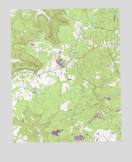
De Rossett, TN USGS Topographic Map
Click on map above to begin viewing in our Map Viewer.

This topographic map contains these locations and features:
Feature Name Type Latitude Longitude GNIS ID View Map
Anderson CemeteryCemeteryN35.8878°W85.3741°1269185View Map
Arrowhead LakeReservoirN35.9593°W85.3191°1269247View Map
Arrowhead Lake DamDamN35.9601°W85.3183°1269248View Map
Big Lost CreekStreamN35.8859°W85.3461°1305218View Map
Billy Branch DamDamN35.8834°W85.3283°1269236View Map
Billy Branch LakeReservoirN35.8842°W85.3248°1269235View Map
Bon AirPopulated PlaceN35.9412°W85.3625°1305339View Map
Bon Air CemeteryCemeteryN35.9359°W85.3625°1269193View Map
Bon Air School (historical)SchoolN35.9423°W85.3614°1321170View Map
Bon De Croft Division (historical)CensusN35.9178°W85.3489°1649016View Map
Bon De Croft Elementary SchoolSchoolN35.9428°W85.3314°1321171View Map
Buck Creek LakeReservoirN35.9813°W85.2802°1269196View Map
Camp Belle AireLocaleN35.9231°W85.3477°1269198View Map
Chestnut MountainSummitN35.8873°W85.3016°1269202View Map
ClarktownPopulated PlaceN35.9331°W85.3100°1314849View Map
Commissioner District 4CivilN35.8799°W85.3351°2464099View Map
Davis Lake Dam Number TwoDamN35.8817°W85.2666°1269234View Map
Davis Lake Number TwoReservoirN35.8817°W85.2666°1269233View Map
De RossettPopulated PlaceN35.9506°W85.3089°1269205View Map
De Rossett Church of ChristChurchN35.9453°W85.3144°1321182View Map
District 2 Fire and Rescue Bon de CroftBuildingN35.9418°W85.3317°2654816View Map
District 9 Eastland Fire and RescueBuildingN35.8808°W85.2906°2654855View Map
Doe Creek LakeLakeN35.9595°W85.3027°1269207View Map
Doe Creek LakeReservoirN35.9584°W85.3066°1269245View Map
Doe Creek Lake DamDamN35.9584°W85.3066°1269246View Map
Eastland Stand (historical)LocaleN35.9034°W85.2694°1321190View Map
Key Acres DamDamN35.9684°W85.3516°1269250View Map
Key Acres LakeReservoirN35.9674°W85.3504°1269249View Map
Little Lost CreekStreamN35.8962°W85.3514°1269217View Map
Lost CreekPopulated PlaceN35.8773°W85.3625°1315436View Map
Lost Creek CemeteryCemeteryN35.8806°W85.3702°1321199View Map
McKinney CemeteryCemeteryN35.9667°W85.2636°1318192View Map
Millsea BranchStreamN35.8862°W85.2514°1269220View Map
MobraPopulated PlaceN35.8817°W85.2600°1315526View Map
Payne LakeReservoirN35.9261°W85.3489°1269241View Map
Payne Lake DamDamN35.9251°W85.3500°1269242View Map
Pole Bridge BranchStreamN35.9056°W85.3216°1269226View Map
RavenscroftPopulated PlaceN35.9773°W85.2952°1269229View Map
Ravenscroft School (historical)SchoolN35.9756°W85.2975°1321221View Map
Saint Charles ChurchChurchN35.8828°W85.2594°1269232View Map
Spain LakeReservoirN35.9216°W85.3442°1269240View Map
Spain Lake DamDamN35.9217°W85.3483°1269239View Map
StringtownPopulated PlaceN35.8928°W85.3019°1314348View Map
Stringtown CemeteryCemeteryN35.8937°W85.3016°1321231View Map
Twin BranchStreamN35.9906°W85.3311°1269181View Map
Wonder DamDamN35.9501°W85.3233°1269244View Map
Wonder LakeReservoirN35.9497°W85.3197°1269243View Map

Note: Coordinates in the location and feature list above are referenced to NAD83 datum.


Copyright (C) 2008-2025 Ryan Niemi / Sunset Dynamics ... All Rights Reserved