TopoQuest Logo
Do you find TopoQuest useful?
Help keep TopoQuest running and adding new maps/features by donating!
Bitcoin:  19c7KJd3qBynnjoSw5npx9KScwjBe4ifkT
Litecoin:  LXs6TkuXGGXo1vDsWCkWVdjQX94eUKd6ui
Home View Maps Find Maps Find Places Resources & Links


Campbell Junction, Tennessee Topographic Map

USGS Map Title: Campbell Junction, TN
USGS Map MRC: 36085A2
DRG (GeoTIFF) Download: o36085a2.tif


Neighboring USGS Topographic Map Quads:


  Monterey, TN  
36085B3
 

  Obey City, TN  
36085B2
 

  Clarkrange, TN  
36085B1
 

  Monterey Lake, TN  
36085A3
 

  Campbell Junction, TN  
36085A2
 

  Isoline, TN  
36085A1
 

  De Rossett, TN  
35085H3
 

  Pleasant Hill, TN  
35085H2
 

  Crossville, TN  
35085H1


Map MRC Location:

N37°
W86°
N37°
W85°
H8 H7 H6 H5 H4 H3 H2 H1
G8 G7 G6 G5 G4 G3 G2 G1
F8 F7 F6 F5 F4 F3 F2 F1
E8 E7 E6 E5 E4 E3 E2 E1
D8 D7 D6 D5 D4 D3 D2 D1
C8 C7 C6 C5 C4 C3 C2 C1
B8 B7 B6 B5 B4 B3 B2 B1
A8 A7 A6 A5 A4 A3 A2 A1
N36°
W86°
N36°
W85°

Campbell Junction, TN USGS 1:24K Topographic Map Preview:
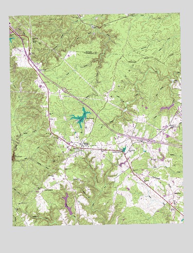
Campbell Junction, TN USGS Topographic Map
Click on map above to begin viewing in our Map Viewer.

This topographic map contains these locations and features:
Feature Name Type Latitude Longitude GNIS ID View Map
Bartlett CreekStreamN36.1081°W85.1352°1304977View Map
Buck BranchStreamN36.1162°W85.1861°1278793View Map
Camp NakanawaLocaleN36.0634°W85.1955°1279404View Map
Campbell JunctionPopulated PlaceN36.0437°W85.1691°1314789View Map
Cumberland County Fire Department Station 7BuildingN36.0665°W85.1260°2654759View Map
Cumberland County Fire Department Station 7 - 2BuildingN36.0482°W85.1984°2654946View Map
Custard CemeteryCemeteryN36.0384°W85.1444°1306247View Map
Devil CreekStreamN36.0401°W85.2491°1282380View Map
Dripping SpringsLocaleN36.0934°W85.2311°1282801View Map
Dripping Springs CreekStreamN36.1212°W85.1905°1282803View Map
Drowning CreekPopulated PlaceN36.0551°W85.1375°1302857View Map
Flat Rock SidingLocaleN36.1095°W85.2344°1284422View Map
Funnel BranchStreamN36.0131°W85.1908°1285035View Map
Funnel RockPillarN36.0270°W85.2047°1285036View Map
George BranchStreamN36.0992°W85.1836°1285289View Map
Gum BranchStreamN36.0620°W85.1744°1286398View Map
Hillwood EstatesPopulated PlaceN36.1156°W85.2439°1310922View Map
Hood LakeReservoirN36.0388°W85.1396°1302330View Map
Hood Lake DamDamN36.0367°W85.1400°1302331View Map
Horn HollowValleyN36.0199°W85.1851°1288358View Map
Interchange 311CrossingN36.0495°W85.1486°1302888View Map
Long BranchStreamN36.0831°W85.1325°1291882View Map
MaylandPopulated PlaceN36.0467°W85.2000°1293017View Map
Mayland Baptist ChurchChurchN36.0506°W85.1977°1318148View Map
Mayland CemeteryCemeteryN36.0509°W85.1977°1318149View Map
Mayland Census Designated PlaceCensusN36.0512°W85.2025°2586069View Map
Mayland LakeReservoirN36.0642°W85.1985°1293018View Map
Mayland Lake DamDamN36.0699°W85.1969°1307183View Map
Mayland SchoolSchoolN36.0503°W85.1989°1318150View Map
Mayland Town HallBuildingN36.0487°W85.1986°1646860View Map
Panther CreekStreamN36.0848°W85.1308°1296736View Map
Pomana RoadLocaleN36.0178°W85.1322°1298083View Map
Pomona RoadPopulated PlaceN36.0167°W85.1319°1302946View Map
Poplar BranchStreamN36.0715°W85.1650°1298171View Map
Pugh CemeteryCemeteryN36.0839°W85.1291°1298655View Map
Rains CemeteryCemeteryN36.0470°W85.1919°1298847View Map
Stillhouse RockCliffN36.0412°W85.2483°1271431View Map
The CowpensLocaleN36.0226°W85.2239°1272384View Map
Verble HollowValleyN36.1151°W85.2487°1273421View Map
Verble KnobsSummitN36.1226°W85.2150°1273423View Map
Walker HollowValleyN36.0526°W85.2442°1273629View Map
WelchLocaleN36.0631°W85.2214°1318147View Map
Welch CemeteryCemeteryN36.0770°W85.2064°1274072View Map
Whiteoak BranchStreamN36.0403°W85.2352°1274425View Map

Note: Coordinates in the location and feature list above are referenced to NAD83 datum.


Copyright (C) 2008-2025 Ryan Niemi / Sunset Dynamics ... All Rights Reserved