TopoQuest Logo
Do you find TopoQuest useful?
Help keep TopoQuest running and adding new maps/features by donating!
Bitcoin:  19c7KJd3qBynnjoSw5npx9KScwjBe4ifkT
Litecoin:  LXs6TkuXGGXo1vDsWCkWVdjQX94eUKd6ui
Home View Maps Find Maps Find Places Resources & Links


De Valls Bluff SE, Arkansas Topographic Map

USGS Map Title: De Valls Bluff SE, AR
USGS Map MRC: 34091G3
DRG (GeoTIFF) Download: o34091g3.tif


Neighboring USGS Topographic Map Quads:


  Des Arc East, AR  
34091H4
 

  De Valls Bluff NE, AR  
34091H3
 

  Brinkley, AR  
34091H2
 

  De Valls Bluff, AR  
34091G4
 

  De Valls Bluff SE, AR  
34091G3
 

  Keevil, AR  
34091G2
 

  Roe, AR  
34091F4
 

  Clarendon, AR  
34091F3
 

  Park Grove, AR  
34091F2


Map MRC Location:

N35°
W92°
N35°
W91°
H8 H7 H6 H5 H4 H3 H2 H1
G8 G7 G6 G5 G4 G3 G2 G1
F8 F7 F6 F5 F4 F3 F2 F1
E8 E7 E6 E5 E4 E3 E2 E1
D8 D7 D6 D5 D4 D3 D2 D1
C8 C7 C6 C5 C4 C3 C2 C1
B8 B7 B6 B5 B4 B3 B2 B1
A8 A7 A6 A5 A4 A3 A2 A1
N34°
W92°
N34°
W91°

De Valls Bluff SE, AR USGS 1:24K Topographic Map Preview:
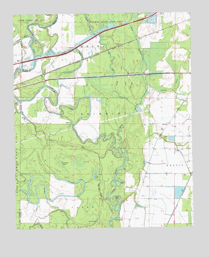
De Valls Bluff SE, AR USGS Topographic Map
Click on map above to begin viewing in our Map Viewer.

This topographic map contains these locations and features:
Feature Name Type Latitude Longitude GNIS ID View Map
AllendalePopulated PlaceN34.8104°W91.2665°57259View Map
Bayou De ViewStreamN34.7918°W91.2976°67001View Map
Big Robe BayouSwampN34.8412°W91.3085°46590View Map
Channey SloughGutN34.8315°W91.2632°47691View Map
Choctaw CemeteryCemeteryN34.8026°W91.2704°47763View Map
Crosspond BayouLakeN34.8554°W91.3337°48210View Map
DagmarPopulated PlaceN34.8562°W91.3007°56982View Map
Dobbs LandingPopulated PlaceN34.7554°W91.3060°56990View Map
EdenPopulated PlaceN34.8637°W91.2746°57699View Map
Fish LakeLakeN34.7805°W91.3186°74830View Map
Fish Lake SloughGutN34.7715°W91.3154°49064View Map
Goose LakeLakeN34.7773°W91.3649°74850View Map
Horseshoe LakeLakeN34.7768°W91.3312°74911View Map
Ingram LakeLakeN34.7662°W91.3040°74922View Map
Jackson BayouStreamN34.8615°W91.3612°77358View Map
Jones IslandAreaN34.8681°W91.2790°61122View Map
Little Robe BayouStreamN34.8190°W91.2893°51320View Map
Long LakeLakeN34.7534°W91.3193°74990View Map
Lost LakeLakeN34.8104°W91.3357°74997View Map
Maloy BayouGutN34.7993°W91.3365°51630View Map
Maloy LakeLakeN34.8232°W91.3748°75014View Map
McFarland BrakeSwampN34.7878°W91.3432°51832View Map
Ninety PointBendN34.7762°W91.3026°52779View Map
Philadelphia CemeteryCemeteryN34.8237°W91.2540°53319View Map
Philadelphia Church (historical)ChurchN34.8243°W91.2540°61125View Map
Rainbow LakeLakeN34.7682°W91.3529°75093View Map
Reeses ForkGutN34.7534°W91.3587°53976View Map
Sevenmile BayouStreamN34.7645°W91.3598°78316View Map
Straight LakeLakeN34.7690°W91.3660°75146View Map
Township of BrownCivilN34.8717°W91.3220°68868View Map

Note: Coordinates in the location and feature list above are referenced to NAD83 datum.


Copyright (C) 2008-2024 Ryan Niemi / Sunset Dynamics ... All Rights Reserved