TopoQuest Logo
Do you find TopoQuest useful?
Help keep TopoQuest running and adding new maps/features by donating!
Bitcoin:  19c7KJd3qBynnjoSw5npx9KScwjBe4ifkT
Litecoin:  LXs6TkuXGGXo1vDsWCkWVdjQX94eUKd6ui
Home View Maps Find Maps Find Places Resources & Links


De Valls Bluff, Arkansas Topographic Map

USGS Map Title: De Valls Bluff, AR
USGS Map MRC: 34091G4
DRG (GeoTIFF) Download: o34091g4.tif


Neighboring USGS Topographic Map Quads:


  Des Arc West, AR  
34091H5
 

  Des Arc East, AR  
34091H4
 

  De Valls Bluff NE, AR  
34091H3
 

  Hazen, AR  
34091G5
 

  De Valls Bluff, AR  
34091G4
 

  De Valls Bluff SE, AR  
34091G3
 

  Slovak, AR  
34091F5
 

  Roe, AR  
34091F4
 

  Clarendon, AR  
34091F3


Map MRC Location:

N35°
W92°
N35°
W91°
H8 H7 H6 H5 H4 H3 H2 H1
G8 G7 G6 G5 G4 G3 G2 G1
F8 F7 F6 F5 F4 F3 F2 F1
E8 E7 E6 E5 E4 E3 E2 E1
D8 D7 D6 D5 D4 D3 D2 D1
C8 C7 C6 C5 C4 C3 C2 C1
B8 B7 B6 B5 B4 B3 B2 B1
A8 A7 A6 A5 A4 A3 A2 A1
N34°
W92°
N34°
W91°

De Valls Bluff, AR USGS 1:24K Topographic Map Preview:
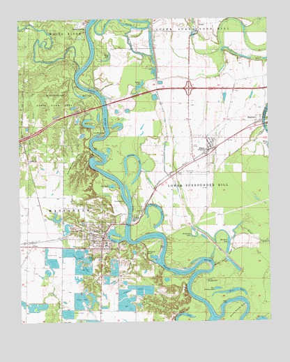
De Valls Bluff, AR USGS Topographic Map
Click on map above to begin viewing in our Map Viewer.

This topographic map contains these locations and features:
Feature Name Type Latitude Longitude GNIS ID View Map
Argo ReservoirReservoirN34.7913°W91.4830°80338View Map
Argo Reservoir DamDamN34.7918°W91.4801°80337View Map
Arkapola BluffCliffN34.7790°W91.4365°45926View Map
Berden Slough BendBendN34.7848°W91.4287°59980View Map
BeulahPopulated PlaceN34.8731°W91.4090°77333View Map
Big Brushy LakeLakeN34.7637°W91.4017°74659View Map
BiscoePopulated PlaceN34.8209°W91.4043°76355View Map
Biscoe CemeteryCemeteryN34.8120°W91.4193°46644View Map
Biscoe Volunteer Fire StationBuildingN34.8191°W91.4056°2116155View Map
Black LakeLakeN34.8581°W91.4572°74676View Map
Blue LakeLakeN34.8063°W91.4539°74686View Map
BrasfieldPopulated PlaceN34.8329°W91.3807°76412View Map
Bucks LandingPopulated PlaceN34.8706°W91.4662°57461View Map
Burnt BayouGutN34.7843°W91.3807°47211View Map
Catfish LakeReservoirN34.7594°W91.4643°81261View Map
Catfish Lake DamDamN34.7618°W91.4651°81260View Map
City of De Valls BluffCivilN34.7858°W91.4605°2404204View Map
Clark CreekStreamN34.8473°W91.4696°47802View Map
Coles BendBendN34.8004°W91.4471°59984View Map
De Valls BluffPopulated PlaceN34.7848°W91.4585°76762View Map
De Valls Bluff First Baptist ChurchChurchN34.7837°W91.4593°70149View Map
De Valls Bluff Police DepartmentBuildingN34.7903°W91.4536°2118689View Map
De Valls Bluff Post OfficePost OfficeN34.7810°W91.4649°2781896View Map
De Valls Bluff Volunteer Fire DepartmentBuildingN34.7856°W91.4578°2116346View Map
DeValls Bluff Elementary SchoolSchoolN34.7817°W91.4575°59991View Map
DeValls Bluff High SchoolSchoolN34.7818°W91.4568°59992View Map
Dunns Shanty PointCapeN34.7548°W91.3929°48717View Map
Fisher LandingLocaleN34.8404°W91.4565°59996View Map
Frakers ReservoirReservoirN34.7568°W91.4919°59998View Map
HallsvillePopulated PlaceN34.8168°W91.4954°57042View Map
Harris CemeteryCemeteryN34.8120°W91.4171°77128View Map
Hendricks LakeLakeN34.7851°W91.4129°74888View Map
Hider BendBendN34.7587°W91.3937°60008View Map
Hodges LakeLakeN34.8476°W91.4393°77343View Map
Horseshoe LakeLakeN34.8077°W91.4435°77229View Map
Interchange 202CrossingN34.8462°W91.4146°59022View Map
Little Brushy LakeLakeN34.7671°W91.4070°74949View Map
Little HillSummitN34.7832°W91.3893°60019View Map
Little Mill PointCapeN34.8273°W91.4574°51297View Map
Maloy BayouStreamN34.8290°W91.3765°51631View Map
MesaPopulated PlaceN34.7818°W91.4937°58167View Map
Miers LakeReservoirN34.7676°W91.4705°81259View Map
Miers Lake DamDamN34.7668°W91.4701°81258View Map
Miller CreekStreamN34.8423°W91.4943°52063View Map
Miller LakeLakeN34.7624°W91.3948°75024View Map
Moores LakeLakeN34.8437°W91.4693°77686View Map
Oakland CemeteryCemeteryN34.7856°W91.4679°52966View Map
Old River LakeLakeN34.7837°W91.4032°75056View Map
Pfennighausen RidgeRidgeN34.8176°W91.4721°53317View Map
Pumps BendBendN34.7740°W91.4043°60046View Map
Slippery LakeLakeN34.8626°W91.4424°75131View Map
The BasinLakeN34.7843°W91.4551°75168View Map
Thomas Allen PointCapeN34.8179°W91.4618°55519View Map
Town of Fredonia (Biscoe)CivilN34.8187°W91.4104°2406523View Map
Township of Lower Surrounded HillCivilN34.8153°W91.4104°69007View Map
Township of WatensawCivilN34.7642°W91.4707°78867View Map
Twin LakesLakeN34.8011°W91.4507°75186View Map
Union ChapelChurchN34.7501°W91.4793°55787View Map
Upshaw LakeLakeN34.7892°W91.4329°75198View Map
Wattensaw BayouStreamN34.8540°W91.4707°78707View Map
Webb LakeLakeN34.8310°W91.4652°75210View Map
Webb Lake BendBendN34.8420°W91.4585°60062View Map
White Oak RidgeRidgeN34.7759°W91.3979°56294View Map
White River BridgeBridgeN34.7904°W91.4457°61692View Map
Worshams BluffCliffN34.7634°W91.4165°56548View Map
Yuma (historical)Populated PlaceN34.8359°W91.4979°77330View Map

Note: Coordinates in the location and feature list above are referenced to NAD83 datum.


Copyright (C) 2008-2024 Ryan Niemi / Sunset Dynamics ... All Rights Reserved