TopoQuest Logo
Do you find TopoQuest useful?
Help keep TopoQuest running and adding new maps/features by donating!
Bitcoin:  19c7KJd3qBynnjoSw5npx9KScwjBe4ifkT
Litecoin:  LXs6TkuXGGXo1vDsWCkWVdjQX94eUKd6ui
Home View Maps Find Maps Find Places Resources & Links


Des Arc East, Arkansas Topographic Map

USGS Map Title: Des Arc East, AR
USGS Map MRC: 34091H4
DRG (GeoTIFF) Download: o34091h4.tif


Neighboring USGS Topographic Map Quads:


  Jasmine, AR  
35091A5
 

  Gregory SW, AR  
35091A4
 

  Cotton Plant, AR  
35091A3
 

  Des Arc West, AR  
34091H5
 

  Des Arc East, AR  
34091H4
 

  De Valls Bluff NE, AR  
34091H3
 

  Hazen, AR  
34091G5
 

  De Valls Bluff, AR  
34091G4
 

  De Valls Bluff SE, AR  
34091G3


Map MRC Location:

N35°
W92°
N35°
W91°
H8 H7 H6 H5 H4 H3 H2 H1
G8 G7 G6 G5 G4 G3 G2 G1
F8 F7 F6 F5 F4 F3 F2 F1
E8 E7 E6 E5 E4 E3 E2 E1
D8 D7 D6 D5 D4 D3 D2 D1
C8 C7 C6 C5 C4 C3 C2 C1
B8 B7 B6 B5 B4 B3 B2 B1
A8 A7 A6 A5 A4 A3 A2 A1
N34°
W92°
N34°
W91°

Des Arc East, AR USGS 1:24K Topographic Map Preview:
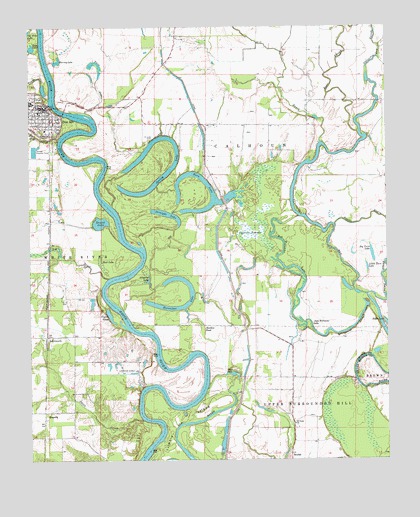
Des Arc East, AR USGS Topographic Map
Click on map above to begin viewing in our Map Viewer.

This topographic map contains these locations and features:
Feature Name Type Latitude Longitude GNIS ID View Map
Alligator LakeLakeN34.9267°W91.4586°74627View Map
Bay PlantationPopulated PlaceN34.9656°W91.3840°59978View Map
Bean LakeLakeN34.9941°W91.4989°74640View Map
Bear SloughStreamN34.9695°W91.3846°46239View Map
Beaver BayouStreamN34.9431°W91.3935°46258View Map
Biene CreekStreamN34.9681°W91.4896°46500View Map
Big CreekStreamN34.9276°W91.4729°46530View Map
Big Twin LakeLakeN34.9342°W91.3802°74670View Map
Blue HoleLakeN34.8998°W91.4293°74683View Map
Bob Williams LakeLakeN34.9302°W91.4098°76385View Map
Cagles EddyLakeN34.9168°W91.4722°74726View Map
Culotches Bay SloughStreamN34.9226°W91.3821°76727View Map
Cypress SwampSwampN34.9417°W91.4209°48322View Map
Des ArcPopulated PlaceN34.9770°W91.4951°76785View Map
Des Arc High SchoolSchoolN34.9785°W91.4991°59990View Map
Des Arc Police DepartmentBuildingN34.9763°W91.4949°2118609View Map
Des Arc Volunteer Fire DepartmentBuildingN34.9771°W91.4954°2116358View Map
Eddy LakeReservoirN34.9206°W91.4783°80328View Map
Eddy Lake DamDamN34.9218°W91.4785°80327View Map
ErwinPopulated PlaceN34.9720°W91.4468°59993View Map
First Presbyterian ChurchChurchN34.9773°W91.4982°61690View Map
GospodaPopulated PlaceN34.8887°W91.4951°57836View Map
Graveyard SloughLakeN34.9116°W91.3910°49604View Map
Harrys (historical)Populated PlaceN34.9551°W91.4929°77328View Map
Harvey LakeLakeN34.9902°W91.4900°74885View Map
Hill BayouStreamN34.9665°W91.3979°50109View Map
Horn LakeLakeN34.9471°W91.4406°74906View Map
Horseshoe LakeLakeN34.9189°W91.4513°77344View Map
Jake Williams LakeLakeN34.9126°W91.4043°50577View Map
LetchworthPopulated PlaceN34.9109°W91.4943°57091View Map
Little Twin LakeLakeN34.9305°W91.3821°74978View Map
Mud LakeSwampN34.9317°W91.4749°52520View Map
Old RiverGutN34.8781°W91.4471°53019View Map
PlunkettsPopulated PlaceN34.9098°W91.4062°60044View Map
Prairie County CourthouseBuildingN34.9768°W91.4935°61691View Map
Prairie County Sheriff's OfficeBuildingN34.9776°W91.4944°2118610View Map
Round LakeLakeN34.9436°W91.4753°75111View Map
Saint Luke CemeteryCemeteryN34.9673°W91.4579°54379View Map
Saint Pauls ChurchChurchN34.8854°W91.4079°54457View Map
Sandy BankLocaleN34.8981°W91.3871°60049View Map
Sholden PondSwampN34.9118°W91.4391°54817View Map
Snipe CreekStreamN34.8868°W91.4610°54982View Map
Spring LakeLakeN34.9529°W91.4583°75140View Map
Straight LakeLakeN34.9458°W91.4520°75148View Map
Township of CalhounCivilN34.9825°W91.4213°69002View Map
Township of Upper Surrounded HillCivilN34.8857°W91.4095°69011View Map
Trimble IslandIslandN34.8870°W91.4499°55651View Map
Tubbs CreekStreamN34.9793°W91.4932°55672View Map
Twin LakesLakeN34.9894°W91.4768°75187View Map
Watson Church (historical)ChurchN34.9723°W91.4390°60060View Map
Weeks LandingLocaleN34.8965°W91.4599°60063View Map
Wilds BendBendN34.8965°W91.4390°60066View Map
Wilds LandingLocaleN34.8993°W91.4376°60067View Map

Note: Coordinates in the location and feature list above are referenced to NAD83 datum.


Copyright (C) 2008-2024 Ryan Niemi / Sunset Dynamics ... All Rights Reserved