TopoQuest Logo
Do you find TopoQuest useful?
Help keep TopoQuest running and adding new maps/features by donating!
Bitcoin:  19c7KJd3qBynnjoSw5npx9KScwjBe4ifkT
Litecoin:  LXs6TkuXGGXo1vDsWCkWVdjQX94eUKd6ui
Home View Maps Find Maps Find Places Resources & Links


Deadwood North, South Dakota Topographic Map

USGS Map Title: Deadwood North, SD
USGS Map MRC: 44103D6
DRG (GeoTIFF) Download: o44103d6.tif


Neighboring USGS Topographic Map Quads:


  Jolly, SD  
44103E7
 

  Saint Onge, SD  
44103E6
 

  Saint Onge SE, SD  
44103E5
 

  Spearfish, SD  
44103D7
 

  Deadwood North, SD  
44103D6
 

  Sturgis, SD  
44103D5
 

  Lead, SD  
44103C7
 

  Deadwood South, SD  
44103C6
 

  Deadman Mountain, SD  
44103C5


Map MRC Location:

N45°
W104°
N45°
W103°
H8 H7 H6 H5 H4 H3 H2 H1
G8 G7 G6 G5 G4 G3 G2 G1
F8 F7 F6 F5 F4 F3 F2 F1
E8 E7 E6 E5 E4 E3 E2 E1
D8 D7 D6 D5 D4 D3 D2 D1
C8 C7 C6 C5 C4 C3 C2 C1
B8 B7 B6 B5 B4 B3 B2 B1
A8 A7 A6 A5 A4 A3 A2 A1
N44°
W104°
N44°
W103°

Deadwood North, SD USGS 1:24K Topographic Map Preview:
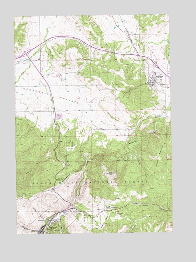
Deadwood North, SD USGS Topographic Map
Click on map above to begin viewing in our Map Viewer.

This topographic map contains these locations and features:
Feature Name Type Latitude Longitude GNIS ID View Map
Adams MuseumBuildingN44.3758°W103.7295°2727335View Map
Anderson CemeteryCemeteryN44.4745°W103.6898°1261188View Map
Black HillsRangeN44.4167°W103.7088°1267020View Map
Centennial City (historical)Populated PlaceN44.4347°W103.6352°1264571View Map
Centennial PrairieFlatN44.4567°W103.7421°1261430View Map
ChinatownPopulated PlaceN44.3792°W103.7213°1262959View Map
City CreekStreamN44.3764°W103.7327°1261447View Map
City of DeadwoodCivilN44.3815°W103.7240°1267350View Map
City of WhitewoodCivilN44.4618°W103.6381°1267655View Map
Crook CityPopulated PlaceN44.4414°W103.6335°1265170View Map
Crook MountainSummitN44.4169°W103.6355°1261506View Map
DeadwoodPopulated PlaceN44.3767°W103.7296°1265180View Map
Deadwood Post OfficePost OfficeN44.3753°W103.7295°2709811View Map
Deadwood Public LibraryBuildingN44.3764°W103.7320°2723454View Map
Elizabethtown (historical)Populated PlaceN44.3875°W103.7033°1263421View Map
Elkhorn PeakSummitN44.4749°W103.7024°1261637View Map
Glen Baker Irrigation DamDamN44.4517°W103.7288°1262837View Map
Interchange 17CrossingN44.4786°W103.7411°2725765View Map
Interchange 23CrossingN44.4709°W103.6369°2725766View Map
KDSJ-AM (Deadwood)TowerN44.3825°W103.6627°1262779View Map
KDSJ-AM (Deadwood)TowerN44.3858°W103.6696°1262780View Map
Lawrence County CourthouseBuildingN44.3754°W103.7296°2712673View Map
Lead-Deadwood Elementary SchoolSchoolN44.3754°W103.7323°2728897View Map
Miller CreekStreamN44.4844°W103.7255°1262076View Map
Mount Moriah CemeteryCemeteryN44.3761°W103.7256°1262096View Map
Mountain MeadowFlatN44.3889°W103.6796°1266857View Map
Mountain Meadows I (historical)LocaleN44.4000°W103.6624°1264554View Map
Nemo District Ranger StationLocaleN44.3808°W103.7252°1263091View Map
Oak Flat (historical)LocaleN44.4028°W103.6588°1264548View Map
Oak Ridge CemeteryCemeteryN44.3891°W103.6773°1262159View Map
Peedee GulchValleyN44.3873°W103.6740°1262190View Map
Polo GulchValleyN44.4184°W103.7188°1262226View Map
Preacher Smith MonumentLocaleN44.4061°W103.7180°1262239View Map
Saint Ambrose CemeteryCemeteryN44.3822°W103.7268°1262352View Map
Sandy CreekStreamN44.4200°W103.6549°1262360View Map
Seth Bullock GraveCemeteryN44.3763°W103.7214°1262383View Map
Slaughterhouse GulchValleyN44.4130°W103.6966°1262431View Map
Spearfish Emergency Ambulance Service WhitewoodBuildingN44.4638°W103.6379°2659005View Map
Spring CreekStreamN44.3808°W103.7230°1262486View Map
Spruce GulchValleyN44.3842°W103.7164°1262495View Map
Tunnel (historical)LocaleN44.4203°W103.6944°1264533View Map
Two Bit CreekStreamN44.3872°W103.6310°1262621View Map
Valley Ranch (historical)LocaleN44.4194°W103.6538°1264648View Map
White RocksSummitN44.3766°W103.7204°1262700View Map
WhitewoodPopulated PlaceN44.4611°W103.6385°1262710View Map
Whitewood CemeteryCemeteryN44.4618°W103.6336°2779177View Map
Whitewood City HallBuildingN44.4608°W103.6397°2725398View Map
Whitewood Elementary SchoolSchoolN44.4633°W103.6357°2728974View Map
Whitewood PeakSummitN44.4092°W103.6763°1262712View Map
Whitewood Police DepartmentBuildingN44.4638°W103.6371°2755480View Map
Whitewood Post OfficePost OfficeN44.4671°W103.6374°2712588View Map
Whitewood Public LibraryBuildingN44.4638°W103.6371°2723796View Map
Whitewood Volunteer Fire DepartmentBuildingN44.4638°W103.6378°2580955View Map

Note: Coordinates in the location and feature list above are referenced to NAD83 datum.


Copyright (C) 2008-2025 Ryan Niemi / Sunset Dynamics ... All Rights Reserved