TopoQuest Logo
Do you find TopoQuest useful?
Help keep TopoQuest running and adding new maps/features by donating!
Bitcoin:  19c7KJd3qBynnjoSw5npx9KScwjBe4ifkT
Litecoin:  LXs6TkuXGGXo1vDsWCkWVdjQX94eUKd6ui
Home View Maps Find Maps Find Places Resources & Links


Sturgis, South Dakota Topographic Map

USGS Map Title: Sturgis, SD
USGS Map MRC: 44103D5
DRG (GeoTIFF) Download: o44103d5.tif


Neighboring USGS Topographic Map Quads:


  Saint Onge, SD  
44103E6
 

  Saint Onge SE, SD  
44103E5
 

  Vale, SD  
44103E4
 

  Deadwood North, SD  
44103D6
 

  Sturgis, SD  
44103D5
 

  Fort Meade, SD  
44103D4
 

  Deadwood South, SD  
44103C6
 

  Deadman Mountain, SD  
44103C5
 

  Tilford, SD  
44103C4


Map MRC Location:

N45°
W104°
N45°
W103°
H8 H7 H6 H5 H4 H3 H2 H1
G8 G7 G6 G5 G4 G3 G2 G1
F8 F7 F6 F5 F4 F3 F2 F1
E8 E7 E6 E5 E4 E3 E2 E1
D8 D7 D6 D5 D4 D3 D2 D1
C8 C7 C6 C5 C4 C3 C2 C1
B8 B7 B6 B5 B4 B3 B2 B1
A8 A7 A6 A5 A4 A3 A2 A1
N44°
W104°
N44°
W103°

Sturgis, SD USGS 1:24K Topographic Map Preview:
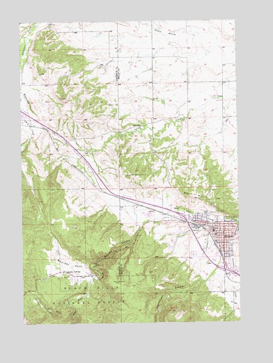
Sturgis, SD USGS Topographic Map
Click on map above to begin viewing in our Map Viewer.

This topographic map contains these locations and features:
Feature Name Type Latitude Longitude GNIS ID View Map
Boulder (historical)LocaleN44.3819°W103.5949°1264642View Map
Boulder CanyonValleyN44.4157°W103.5564°1261324View Map
Boulder CreekStreamN44.3839°W103.5985°1261325View Map
Boulder ParkFlatN44.3992°W103.5974°1261327View Map
Boulder Park SchoolSchoolN44.3958°W103.5994°1261328View Map
Case SchoolSchoolN44.4083°W103.5060°1261415View Map
Crook City CemeteryCemeteryN44.4432°W103.6243°2779172View Map
Deadman GulchValleyN44.3923°W103.5212°1261541View Map
Eden SchoolSchoolN44.4567°W103.5563°1261622View Map
Erskine SchoolSchoolN44.4125°W103.5149°1261650View Map
Granite PeakSummitN44.3917°W103.5699°1261737View Map
Interchange 30CrossingN44.4188°W103.5323°2725767View Map
Interchange 32CrossingN44.3966°W103.5085°2725768View Map
Meade County CourthouseBuildingN44.4139°W103.5164°2712679View Map
Meade County JailBuildingN44.4142°W103.5160°2755662View Map
Meade County Sheriff's OfficeBuildingN44.4143°W103.5157°2755628View Map
Oyster MountainSummitN44.4355°W103.5635°1262172View Map
Saint Aloysius CemeteryCemeteryN44.4143°W103.5195°2779235View Map
Sly HillSummitN44.4264°W103.5262°1262434View Map
Snake BenchBenchN44.4950°W103.5416°1262441View Map
SturgisPopulated PlaceN44.4097°W103.5091°1265387View Map
Sturgis City HallBuildingN44.4138°W103.5124°2725282View Map
Sturgis Elementary SchoolSchoolN44.4028°W103.5161°2728971View Map
Sturgis Fire and Emergency ServicesBuildingN44.4047°W103.5196°2580684View Map
Sturgis Motorcycle Museum and Hall of FameBuildingN44.4146°W103.5087°2729342View Map
Sturgis Police DepartmentBuildingN44.4143°W103.5160°2755489View Map
Sturgis Post OfficePost OfficeN44.4169°W103.5147°2711905View Map
Sturgis Public LibraryBuildingN44.4138°W103.5124°2723683View Map
Sturgis Regional HospitalHospitalN44.4021°W103.5068°2610943View Map
Sturgis Sandstone QuarryMineN44.3930°W103.5435°1264696View Map
Vanocker CreekStreamN44.4161°W103.5021°1262631View Map
Williams Junior High SchoolSchoolN44.4114°W103.5138°1262723View Map

Note: Coordinates in the location and feature list above are referenced to NAD83 datum.


Copyright (C) 2008-2025 Ryan Niemi / Sunset Dynamics ... All Rights Reserved