TopoQuest Logo
Do you find TopoQuest useful?
Help keep TopoQuest running and adding new maps/features by donating!
Bitcoin:  19c7KJd3qBynnjoSw5npx9KScwjBe4ifkT
Litecoin:  LXs6TkuXGGXo1vDsWCkWVdjQX94eUKd6ui
Home View Maps Find Maps Find Places Resources & Links


Deadwood South, South Dakota Topographic Map

USGS Map Title: Deadwood South, SD
USGS Map MRC: 44103C6
DRG (GeoTIFF) Download: o44103c6.tif


Neighboring USGS Topographic Map Quads:


  Spearfish, SD  
44103D7
 

  Deadwood North, SD  
44103D6
 

  Sturgis, SD  
44103D5
 

  Lead, SD  
44103C7
 

  Deadwood South, SD  
44103C6
 

  Deadman Mountain, SD  
44103C5
 

  Nahant, SD  
44103B7
 

  Minnesota Ridge, SD  
44103B6
 

  Nemo, SD  
44103B5


Map MRC Location:

N45°
W104°
N45°
W103°
H8 H7 H6 H5 H4 H3 H2 H1
G8 G7 G6 G5 G4 G3 G2 G1
F8 F7 F6 F5 F4 F3 F2 F1
E8 E7 E6 E5 E4 E3 E2 E1
D8 D7 D6 D5 D4 D3 D2 D1
C8 C7 C6 C5 C4 C3 C2 C1
B8 B7 B6 B5 B4 B3 B2 B1
A8 A7 A6 A5 A4 A3 A2 A1
N44°
W104°
N44°
W103°

Deadwood South, SD USGS 1:24K Topographic Map Preview:
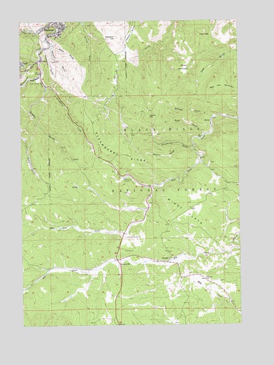
Deadwood South, SD USGS Topographic Map
Click on map above to begin viewing in our Map Viewer.

This topographic map contains these locations and features:
Feature Name Type Latitude Longitude GNIS ID View Map
Alexander MineMineN44.3222°W103.6449°1264761View Map
Alice MineMineN44.3180°W103.6421°1264760View Map
Allerton (historical)LocaleN44.2875°W103.6785°1264658View Map
Anchor HillSummitN44.3356°W103.6768°1261187View Map
Anchor Mountain MineMineN44.3375°W103.6746°1264735View Map
Bear Den MountainSummitN44.3464°W103.6407°1261227View Map
Belle Eldridge Gold MineMineN44.3680°W103.7233°1264079View Map
Bion MineMineN44.3208°W103.6519°1264733View Map
Boomer GulchValleyN44.3233°W103.6566°1261321View Map
Branch Mint MineMineN44.3361°W103.6324°1264765View Map
Brownsville (historical)Populated PlaceN44.2753°W103.6944°1265621View Map
Brownsville Volunteer Fire DepartmentBuildingN44.2775°W103.7001°2580938View Map
Bucks (historical)LocaleN44.2805°W103.6344°1264077View Map
Bullion MineMineN44.3264°W103.6407°1264759View Map
Butcher GulchValleyN44.3354°W103.6406°1261381View Map
Camp Galena Post OfficePost OfficeN44.3336°W103.6410°1926748View Map
Carterville (historical)Populated PlaceN44.3375°W103.7463°1264573View Map
Clover Leaf MineMineN44.2769°W103.6671°1264758View Map
Coletta MineMineN44.3139°W103.6519°1264767View Map
Cora MineMineN44.3264°W103.6435°1264757View Map
Custer HillSummitN44.3229°W103.6349°1264768View Map
Custer MineMineN44.3667°W103.6366°1264756View Map
Deadwood City HallBuildingN44.3737°W103.7293°2724708View Map
Deadwood CreekStreamN44.3730°W103.7319°1261543View Map
Deadwood GulchValleyN44.3637°W103.7342°1261544View Map
Deadwood Police DepartmentBuildingN44.3737°W103.7293°2755532View Map
Deadwood Volunteer Fire DepartmentBuildingN44.3746°W103.7318°2580660View Map
Dome MountainSummitN44.3554°W103.6564°1261568View Map
Double Rainbow MineMineN44.3333°W103.6338°1264755View Map
El Refugio MineMineN44.3375°W103.6380°1264754View Map
Florence MineMineN44.3361°W103.6338°1264753View Map
GalenaPopulated PlaceN44.3336°W103.6410°1265226View Map
Galena CemeteryCemeteryN44.3349°W103.6441°2779179View Map
Galena Junction (historical)LocaleN44.2855°W103.6908°1264565View Map
Gilt Edge MineMineN44.3297°W103.6746°1264750View Map
Gold Mountain MineMineN44.3667°W103.6699°1264752View Map
Gold RunStreamN44.3594°W103.7388°1261725View Map
Golden Crest MineMineN44.3305°W103.6908°1264751View Map
Grizzly GulchValleyN44.3480°W103.7357°1261756View Map
Groshong MineMineN44.3167°W103.6921°1264749View Map
Hardin Properties MineMineN44.3555°W103.6944°1264746View Map
Hayes MineMineN44.3208°W103.6449°1264745View Map
Hester A MineMineN44.3278°W103.6532°1264744View Map
Historic Adams HouseBuildingN44.3722°W103.7268°2727336View Map
Hoffman Iron Deposit MineMineN44.3042°W103.6894°1264732View Map
Hoodoo-Union Hill MineMineN44.3311°W103.6746°1264743View Map
Horseshoe-Comet MineMineN44.3278°W103.6394°1264742View Map
Lawrence County JailBuildingN44.3743°W103.7296°2755659View Map
Lawrence County Sheriff's OfficeBuildingN44.3742°W103.7295°2755460View Map
Lead - Deadwood Regional HospitalHospitalN44.3696°W103.7283°2610933View Map
Lexington HillSummitN44.3683°W103.6952°1261948View Map
Lexington Hill Mine (historical)MineN44.3555°W103.7255°1264078View Map
Mary MineMineN44.3389°W103.7074°1264731View Map
Mascot MineMineN44.3722°W103.6685°1264734View Map
Merritt Number 1 and Merritt Number 2 MineMineN44.3333°W103.6394°1264741View Map
Monarch MineMineN44.3425°W103.7088°1264747View Map
Montezuma and the Whizzers MineMineN44.3705°W103.7435°1264729View Map
Olaf Seim MineMineN44.3722°W103.7463°1264081View Map
Oro Fino (historical)MineN44.3264°W103.6727°1264545View Map
Oro Hondo MineMineN44.3358°W103.7438°1264748View Map
Pecks GulchValleyN44.3650°W103.7309°1262189View Map
Pillar PeakSummitN44.3698°W103.6487°1262203View Map
PlumaPopulated PlaceN44.3586°W103.7383°1262222View Map
Puritan MineMineN44.3222°W103.7096°1264728View Map
Rattle Snake Jack MineMineN44.3292°W103.6716°1264740View Map
Red Cloud MineMineN44.3375°W103.6338°1264739View Map
RoubaixPopulated PlaceN44.2758°W103.6663°1265342View Map
Roubaix CemeteryCemeteryN44.2788°W103.6660°2779175View Map
Ruby GulchValleyN44.3287°W103.6454°1262340View Map
S R Smith MineMineN44.3414°W103.7046°1264730View Map
Savage MineMineN44.3305°W103.6366°1264738View Map
Sheeps Trail (historical)LocaleN44.3730°W103.6666°1264646View Map
Silver Queen MineMineN44.3139°W103.6921°1264737View Map
Slavonian MineMineN44.3542°W103.7449°1264727View Map
State Park Post Office (historical)Post OfficeN44.3336°W103.6411°1926754View Map
Strawberry CreekStreamN44.3242°W103.6510°1262521View Map
Strawberry Hill CampgroundLocaleN44.3103°W103.6913°1262522View Map
Strawberry RidgeRidgeN44.3197°W103.6930°1262523View Map
Strawberry Spur (historical)LocaleN44.3236°W103.6352°1264535View Map
The Chicken Ranch (historical)LocaleN44.3111°W103.6769°1264547View Map
Tomahawk Country ClubLocaleN44.2861°W103.6905°1262602View Map
Twobit (historical)LocaleN44.3600°W103.6910°1264176View Map
Virginia (historical)Populated PlaceN44.3264°W103.6491°1264647View Map
War Eagle MineMineN44.3278°W103.6366°1264736View Map
West Strawberry CreekStreamN44.3530°W103.7383°1262678View Map
Whistler GulchValleyN44.3637°W103.7329°1262691View Map
Whitetail (historical)LocaleN44.3305°W103.7463°1264644View Map
Windy FlatsFlatN44.2964°W103.6560°1262735View Map

Note: Coordinates in the location and feature list above are referenced to NAD83 datum.


Copyright (C) 2008-2024 Ryan Niemi / Sunset Dynamics ... All Rights Reserved