TopoQuest Logo
Do you find TopoQuest useful?
Help keep TopoQuest running and adding new maps/features by donating!
Bitcoin:  19c7KJd3qBynnjoSw5npx9KScwjBe4ifkT
Litecoin:  LXs6TkuXGGXo1vDsWCkWVdjQX94eUKd6ui
Home View Maps Find Maps Find Places Resources & Links


Deavertown, Ohio Topographic Map

USGS Map Title: Deavertown, OH
USGS Map MRC: 39082F1
DRG (GeoTIFF) Download: o39082f1.tif


Neighboring USGS Topographic Map Quads:


  Fultonham, OH  
39082G2
 

  Crooksville, OH  
39082G1
 

  Philo, OH  
39081G8
 

  New Lexington, OH  
39082F2
 

  Deavertown, OH  
39082F1
 

  Rokeby Lock, OH  
39081F8
 

  New Straitsville, OH  
39082E2
 

  Corning, OH  
39082E1
 

  Ringgold, OH  
39081E8


Map MRC Location:

N40°
W83°
N40°
W82°
H8 H7 H6 H5 H4 H3 H2 H1
G8 G7 G6 G5 G4 G3 G2 G1
F8 F7 F6 F5 F4 F3 F2 F1
E8 E7 E6 E5 E4 E3 E2 E1
D8 D7 D6 D5 D4 D3 D2 D1
C8 C7 C6 C5 C4 C3 C2 C1
B8 B7 B6 B5 B4 B3 B2 B1
A8 A7 A6 A5 A4 A3 A2 A1
N39°
W83°
N39°
W82°

Deavertown, OH USGS 1:24K Topographic Map Preview:
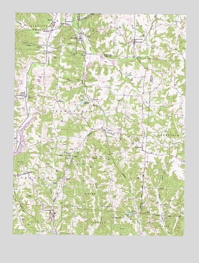
Deavertown, OH USGS Topographic Map
Click on map above to begin viewing in our Map Viewer.

This topographic map contains these locations and features:
Feature Name Type Latitude Longitude GNIS ID View Map
Alabama HillPopulated PlaceN39.6345°W82.0515°1075245View Map
Altiers LakeReservoirN39.6517°W82.0849°1078752View Map
Altiers Lake DamDamN39.6517°W82.0849°1078751View Map
Bear CreekStreamN39.7020°W82.1154°1075323View Map
Bearfield SchoolSchoolN39.7001°W82.0921°1075329View Map
Bennett RunStreamN39.7228°W82.0574°1075348View Map
Bethel CemeteryCemeteryN39.6692°W82.0601°1075356View Map
Breece School (historical)SchoolN39.6573°W82.0529°1065662View Map
Crooksville Airport (historical)AirportN39.7370°W82.0985°1082632View Map
Crooksville High SchoolSchoolN39.7417°W82.0951°1083541View Map
Crooksville ReservoirReservoirN39.6993°W82.0758°1075654View Map
Crooksville Reservoir Number Three DamDamN39.7017°W82.0749°1078997View Map
DeavertownPopulated PlaceN39.7342°W82.0379°1075694View Map
Deavertown Post Office (historical)Post OfficeN39.7348°W82.0374°2038180View Map
Dry RunStreamN39.7440°W82.0810°1075745View Map
Eighteen RunStreamN39.6267°W82.0938°1075789View Map
Fairview ChurchChurchN39.7440°W82.0871°1075830View Map
First Baptist Church CemeteryCemeteryN39.6603°W82.1160°1963621View Map
FlatironPopulated PlaceN39.7453°W82.0976°1075860View Map
Fowler CemeteryCemeteryN39.6785°W82.1243°1080305View Map
Hammond School (historical)SchoolN39.6767°W82.0738°1065667View Map
Harring CemeteryCemeteryN39.6848°W82.0465°1076012View Map
Hebron School (historical)SchoolN39.7062°W82.0938°1065671View Map
Holcomb CemeteryCemeteryN39.7009°W82.0471°1076067View Map
Holcomb School (historical)SchoolN39.7048°W82.0521°1065672View Map
Ileff ChurchChurchN39.7431°W82.0974°1076104View Map
Iliff CemeteryCemeteryN39.7423°W82.0990°1963630View Map
Iron Hill School (historical)SchoolN39.6415°W82.1032°1065673View Map
Jones LakeReservoirN39.7234°W82.0474°1076155View Map
Little RunStreamN39.7123°W82.0749°1076277View Map
McCaslin Family CemeteryCemeteryN39.7328°W82.0868°1963634View Map
McLuneyPopulated PlaceN39.7403°W82.1024°1076369View Map
McLuney CreekStreamN39.7334°W82.0993°1077264View Map
McLuney Post Office (historical)Post OfficeN39.7403°W82.1026°2042302View Map
MilliganPopulated PlaceN39.7278°W82.1018°1065778View Map
Milligan Post Office (historical)Post OfficeN39.7278°W82.1013°2042169View Map
MiscoPopulated PlaceN39.7278°W82.0738°1076409View Map
Misco Post Office (historical)Post OfficeN39.7278°W82.0735°2042170View Map
Moores JunctionPopulated PlaceN39.7031°W82.1163°1076429View Map
OakfieldPopulated PlaceN39.6592°W82.1160°1076543View Map
Oakfield Baptist ChurchChurchN39.6587°W82.1199°1073287View Map
Oakgrove School (historical)SchoolN39.6706°W82.1063°1065677View Map
Ogg CreekStreamN39.7284°W82.0696°1076548View Map
Peeper RunStreamN39.6787°W82.0021°1076612View Map
Pleasant Grove CemeteryCemeteryN39.6701°W82.0840°1963652View Map
Pleasant Grove ChurchChurchN39.6701°W82.0846°1076654View Map
PortersvillePopulated PlaceN39.6748°W82.0310°1076679View Map
Portersville Post Office (historical)Post OfficeN39.6751°W82.0304°2042185View Map
Presbyterian CemeteryCemeteryN39.6581°W82.1199°1963653View Map
Pussy CreekStreamN39.7306°W82.1013°1076696View Map
Rose FarmPopulated PlaceN39.7359°W82.0779°1076770View Map
Rose Farm Census Designated PlaceCensusN39.7358°W82.0778°2628963View Map
Rose Farm Church of ChristChurchN39.7359°W82.0771°1068947View Map
Rose Farm Post Office (historical)Post OfficeN39.7362°W82.0776°2038203View Map
Rose Farm School (historical)SchoolN39.7337°W82.0765°1068948View Map
San ToyPopulated PlaceN39.6562°W82.0357°1077272View Map
San Toy DamDamN39.6367°W82.0382°1078749View Map
San Toy LakeReservoirN39.6367°W82.0382°1078750View Map
Santoy Post Office (historical)Post OfficeN39.6556°W82.0360°2042195View Map
SayrePopulated PlaceN39.6845°W82.0588°1076843View Map
Sayre Post Office (historical)Post OfficeN39.6848°W82.0582°2042301View Map
Shick CemeteryCemeteryN39.7248°W82.0940°1076883View Map
StringtownPopulated PlaceN39.7453°W82.0882°1076981View Map
Teal CemeteryCemeteryN39.7193°W82.1163°1077031View Map
Township of BearfieldCivilN39.6909°W82.0752°1086778View Map
Township of YorkCivilN39.7455°W82.0023°1086696View Map
TropicPopulated PlaceN39.7376°W82.0713°1077074View Map
Tropic Station (historical)LocaleN39.7390°W82.0765°1065732View Map
YellowtownPopulated PlaceN39.7015°W82.0682°1077245View Map
York Elementary SchoolSchoolN39.7328°W82.0379°1071063View Map
Zion CemeteryCemeteryN39.6776°W82.0365°1963664View Map
Zion ChurchChurchN39.6778°W82.0360°1077255View Map

Note: Coordinates in the location and feature list above are referenced to NAD83 datum.


Copyright (C) 2008-2025 Ryan Niemi / Sunset Dynamics ... All Rights Reserved