TopoQuest Logo
Do you find TopoQuest useful?
Help keep TopoQuest running and adding new maps/features by donating!
Bitcoin:  19c7KJd3qBynnjoSw5npx9KScwjBe4ifkT
Litecoin:  LXs6TkuXGGXo1vDsWCkWVdjQX94eUKd6ui
Home View Maps Find Maps Find Places Resources & Links


Ringgold, Ohio Topographic Map

USGS Map Title: Ringgold, OH
USGS Map MRC: 39081E8
DRG (GeoTIFF) Download: o39081e8.tif


Neighboring USGS Topographic Map Quads:


  Deavertown, OH  
39082F1
 

  Rokeby Lock, OH  
39081F8
 

  McConnelsville, OH  
39081F7
 

  Corning, OH  
39082E1
 

  Ringgold, OH  
39081E8
 

  Stockport, OH  
39081E7
 

  Jacksonville, OH  
39082D1
 

  Amesville, OH  
39081D8
 

  Chesterhill, OH  
39081D7


Map MRC Location:

N40°
W82°
N40°
W81°
H8 H7 H6 H5 H4 H3 H2 H1
G8 G7 G6 G5 G4 G3 G2 G1
F8 F7 F6 F5 F4 F3 F2 F1
E8 E7 E6 E5 E4 E3 E2 E1
D8 D7 D6 D5 D4 D3 D2 D1
C8 C7 C6 C5 C4 C3 C2 C1
B8 B7 B6 B5 B4 B3 B2 B1
A8 A7 A6 A5 A4 A3 A2 A1
N39°
W82°
N39°
W81°

Ringgold, OH USGS 1:24K Topographic Map Preview:
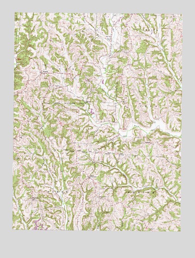
Ringgold, OH USGS Topographic Map
Click on map above to begin viewing in our Map Viewer.

This topographic map contains these locations and features:
Feature Name Type Latitude Longitude GNIS ID View Map
Antioch CemeteryCemeteryN39.5519°W81.9057°1964199View Map
Antioch ChurchChurchN39.5517°W81.9051°1051190View Map
Armstrong School (historical)SchoolN39.5353°W81.9821°1080456View Map
Buck RunStreamN39.6053°W81.9282°1075468View Map
Chaneyville (historical)Populated PlaceN39.6245°W81.9126°1067290View Map
Chaneyville RunStreamN39.6112°W81.8935°1075560View Map
Cheneyville Post Office (historical)Post OfficeN39.6245°W81.9124°2038178View Map
Comstock PondReservoirN39.5677°W81.9413°1078103View Map
Comstock Pond DamDamN39.5684°W81.9432°1078102View Map
Elliott CrossroadsPopulated PlaceN39.5309°W81.9438°1075802View Map
Elliott Post Office (historical)Post OfficeN39.5306°W81.9443°2037874View Map
Fairview ParkParkN39.5015°W81.8976°1075832View Map
Goshen School (historical)SchoolN39.5251°W81.9257°1051187View Map
Hickory Ridge School (historical)SchoolN39.5959°W81.9107°1051192View Map
Hopkins School (historical)SchoolN39.5015°W81.8976°1051189View Map
Little Wolf CreekStreamN39.5545°W81.8754°1076263View Map
Maple Grove School (historical)SchoolN39.5570°W81.9465°1051188View Map
MoodySchoolN39.5287°W81.9679°1051185View Map
Mount Olive CemeteryCemeteryN39.5740°W81.9174°1964216View Map
Mount Olive ChurchChurchN39.5740°W81.9168°1077294View Map
Mount Zion CemeteryCemeteryN39.6028°W81.9159°1076464View Map
MountvillePopulated PlaceN39.5181°W81.9857°1076472View Map
Mountville Post Office (historical)Post OfficeN39.5181°W81.9860°2037877View Map
Pisgah Methodist Protestant CemeteryCemeteryN39.5540°W81.9935°1964222View Map
Pisgah United Methodist ChurchChurchN39.5540°W81.9940°1076650View Map
Pleasant Hill CemeteryCemeteryN39.5192°W81.9354°1068939View Map
Pleasant Hill ChurchChurchN39.5195°W81.9357°1076656View Map
Pleasant Hill School (historical)SchoolN39.5195°W81.9354°1051186View Map
RinggoldPopulated PlaceN39.5903°W81.9796°1076743View Map
Ringgold CemeteryCemeteryN39.5948°W81.9745°1076744View Map
Ringgold Free Methodist ChurchChurchN39.5903°W81.9790°1068944View Map
Ringgold School (historical)SchoolN39.5903°W81.9790°1068945View Map
Rock Hollow School (historical)SchoolN39.5617°W81.9804°1080457View Map
RosseauPopulated PlaceN39.5737°W81.9468°1076773View Map
Rosseau Post Office (historical)Post OfficeN39.5737°W81.9471°2038206View Map
Shilling (historical)Populated PlaceN39.5626°W81.9899°1067294View Map
Shilling Post Office (historical)Post OfficeN39.5626°W81.9901°2038214View Map
Township of HomerCivilN39.5023°W81.9945°1086687View Map
Township of UnionCivilN39.5909°W81.9793°1086694View Map
Union-Homer Elementary SchoolSchoolN39.5415°W81.9971°1085232View Map
West Liberty School (historical)SchoolN39.5673°W81.9143°1051191View Map
WestlandPopulated PlaceN39.5503°W81.8993°1077168View Map
Westland CemeteryCemeteryN39.5434°W81.9082°1077169View Map
Westland Post Office (historical)Post OfficeN39.5501°W81.8999°2038230View Map
White Pigeon School (historical)SchoolN39.5781°W81.8887°1071075View Map
Whitewash School (historical)SchoolN39.5512°W81.8937°1071074View Map
Wildlife Pond 9417-001ReservoirN39.5655°W81.9402°1078101View Map
Wildlife Pond Dam 9417-001DamN39.5651°W81.9399°1078100View Map
Wolf Creek CemeteryCemeteryN39.6103°W81.9279°1068975View Map
Wolf Creek Church of ChristChurchN39.6103°W81.9290°1077222View Map
Wolf Creek Wildlife AreaParkN39.5715°W81.9638°1077223View Map

Note: Coordinates in the location and feature list above are referenced to NAD83 datum.


Copyright (C) 2008-2025 Ryan Niemi / Sunset Dynamics ... All Rights Reserved