TopoQuest Logo
Do you find TopoQuest useful?
Help keep TopoQuest running and adding new maps/features by donating!
Bitcoin:  19c7KJd3qBynnjoSw5npx9KScwjBe4ifkT
Litecoin:  LXs6TkuXGGXo1vDsWCkWVdjQX94eUKd6ui
Home View Maps Find Maps Find Places Resources & Links


Deer Creek, Wyoming Topographic Map

USGS Map Title: Deer Creek, WY
USGS Map MRC: 43110A7
DRG (GeoTIFF) Download: o43110a7.tif


Neighboring USGS Topographic Map Quads:


  Ferry Peak, WY  
43110B8
 

  Pine Creek, WY  
43110B7
 

  Bailey Lake, WY  
43110B6
 

  Stewart Peak, WY  
43110A8
 

  Deer Creek, WY  
43110A7
 

  Pickle Pass, WY  
43110A6
 

  Thayne East, WY  
42110H8
 

  Man Peak, WY  
42110H7
 

  Blind Bull Creek, WY  
42110H6


Map MRC Location:

N44°
W111°
N44°
W110°
H8 H7 H6 H5 H4 H3 H2 H1
G8 G7 G6 G5 G4 G3 G2 G1
F8 F7 F6 F5 F4 F3 F2 F1
E8 E7 E6 E5 E4 E3 E2 E1
D8 D7 D6 D5 D4 D3 D2 D1
C8 C7 C6 C5 C4 C3 C2 C1
B8 B7 B6 B5 B4 B3 B2 B1
A8 A7 A6 A5 A4 A3 A2 A1
N43°
W111°
N43°
W110°

Deer Creek, WY USGS 1:24K Topographic Map Preview:
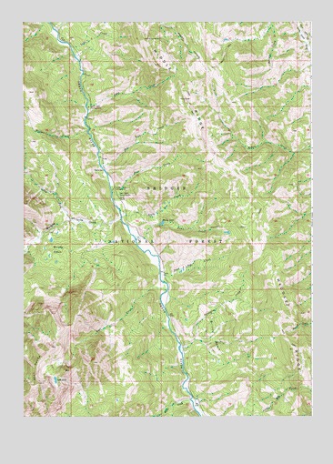
Deer Creek, WY USGS Topographic Map
Click on map above to begin viewing in our Map Viewer.

This topographic map contains these locations and features:
Feature Name Type Latitude Longitude GNIS ID View Map
Dead Dog CreekStreamN43.0449°W110.8155°1587399View Map
Deer CreekStreamN43.0688°W110.8358°1587479View Map
Deer Creek Guard StationLocaleN43.0702°W110.8335°1587494View Map
Fawn CreekStreamN43.0574°W110.8269°1588401View Map
Grizzly BasinBasinN43.0246°W110.7924°1600104View Map
Hot Foot CreekStreamN43.0788°W110.8405°1589751View Map
Lake CreekStreamN43.1174°W110.8541°1590461View Map
Lost CreekStreamN43.0399°W110.8130°1591022View Map
Lost LakeLakeN43.0115°W110.8613°1591044View Map
Lynx CreekStreamN43.0991°W110.8471°1591138View Map
Lynx Creek CampgroundLocaleN43.0980°W110.8463°1597562View Map
Murphy CreekStreamN43.0624°W110.8327°1601643View Map
Murphy Creek CampgroundLocaleN43.0721°W110.8360°1597564View Map
Murphy LakesLakeN43.0532°W110.8660°1591921View Map
North Fork Murphy CreekStreamN43.0621°W110.8549°1601798View Map
Porcupine CreekStreamN43.0224°W110.8069°1592958View Map
South Doe CreekStreamN43.0630°W110.8319°1594611View Map
Star PeaksRidgeN43.0149°W110.8702°1594981View Map
Stewart TrailTrailN43.0721°W110.7649°1603364View Map
Stump LakeLakeN43.0612°W110.8151°1595134View Map
Weiner CreekStreamN43.0905°W110.8471°1604025View Map
White CreekStreamN43.0052°W110.8030°1604137View Map

Note: Coordinates in the location and feature list above are referenced to NAD83 datum.


Copyright (C) 2008-2025 Ryan Niemi / Sunset Dynamics ... All Rights Reserved