TopoQuest Logo
Do you find TopoQuest useful?
Help keep TopoQuest running and adding new maps/features by donating!
Bitcoin:  19c7KJd3qBynnjoSw5npx9KScwjBe4ifkT
Litecoin:  LXs6TkuXGGXo1vDsWCkWVdjQX94eUKd6ui
Home View Maps Find Maps Find Places Resources & Links


Deferiet, New York Topographic Map

USGS Map Title: Deferiet, NY
USGS Map MRC: 44075A6
DRG (GeoTIFF) Download: o44075a6.tif


Neighboring USGS Topographic Map Quads:


  Theresa, NY  
44075B7
 

  Philadelphia, NY  
44075B6
 

  Antwerp, NY  
44075B5
 

  Black River, NY  
44075A7
 

  Deferiet, NY  
44075A6
 

  North Wilna, NY  
44075A5
 

  Rutland Center, NY  
43075H7
 

  Copenhagen, NY  
43075H6
 

  Carthage, NY  
43075H5


Map MRC Location:

N45°
W76°
N45°
W75°
H8 H7 H6 H5 H4 H3 H2 H1
G8 G7 G6 G5 G4 G3 G2 G1
F8 F7 F6 F5 F4 F3 F2 F1
E8 E7 E6 E5 E4 E3 E2 E1
D8 D7 D6 D5 D4 D3 D2 D1
C8 C7 C6 C5 C4 C3 C2 C1
B8 B7 B6 B5 B4 B3 B2 B1
A8 A7 A6 A5 A4 A3 A2 A1
N44°
W76°
N44°
W75°

Deferiet, NY USGS 1:24K Topographic Map Preview:
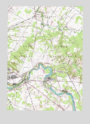
Deferiet, NY USGS Topographic Map
Click on map above to begin viewing in our Map Viewer.

This topographic map contains these locations and features:
Feature Name Type Latitude Longitude GNIS ID View Map
Beaver Meadows CreekStreamN44.1026°W75.6649°943422View Map
CCC CampLocaleN44.0448°W75.6696°945410View Map
Christian Heritage SchoolSchoolN44.0317°W75.7223°2668998View Map
City of Refuge Christian ChurchChurchN44.0318°W75.7223°2615783View Map
DeferietPopulated PlaceN44.0356°W75.6838°948249View Map
Deferiet Union ChurchChurchN44.0395°W75.6840°2615837View Map
Deferiet Volunteer Fire CompanyBuildingN44.0412°W75.6810°2734776View Map
Doolins CrossingPopulated PlaceN44.0848°W75.6780°972390View Map
Fort Drum Fire Department Wheeler Sack Army AirfieldBuildingN44.0587°W75.7108°2734730View Map
Great BendPopulated PlaceN44.0342°W75.7188°951618View Map
Great Bend Census Designated PlaceCensusN44.0197°W75.7075°2389866View Map
Great Bend Volunteer Fire DepartmentBuildingN44.0321°W75.7154°2718598View Map
HerringsPopulated PlaceN44.0240°W75.6538°952642View Map
Herrings Village Wastewater Treatment FacilityLocaleN44.0219°W75.6606°2617727View Map
Hubbard CrossingPopulated PlaceN44.0565°W75.6574°972635View Map
Oliphant HillSummitN44.0409°W75.6388°959341View Map
Pine PlainsFlatN44.0951°W75.7052°960530View Map
ReedvillePopulated PlaceN44.1015°W75.6544°962354View Map
School Number 14 (historical)SchoolN44.0367°W75.6858°975099View Map
School Number 3 (historical)SchoolN44.0081°W75.6694°975294View Map
School Number 4 (historical)SchoolN44.0020°W75.7194°975379View Map
School Number 4 (historical)SchoolN44.1162°W75.7041°975380View Map
School Number 8 (historical)SchoolN44.0242°W75.6549°975614View Map
School Number 9 (historical)SchoolN44.0323°W75.7191°975666View Map
SterlingvillePopulated PlaceN44.1031°W75.6872°973115View Map
Strickland CornersLocaleN44.1153°W75.7044°966638View Map
Sunnyside CemeteryCemeteryN44.0276°W75.7161°949792View Map
Village of DeferietCivilN44.0344°W75.6792°2391634View Map
Village of HerringsCivilN44.0225°W75.6579°2390891View Map
Warren SwampSwampN44.0515°W75.6341°968821View Map
Watertown Korean United Methodist ChurchChurchN44.0333°W75.7186°2617178View Map
West Branch Black CreekStreamN44.0967°W75.6616°969107View Map
Wheeler-Sack Army AirfieldAirportN44.0592°W75.7108°975789View Map
White CreekStreamN44.0045°W75.7413°971093View Map
Woolworth Memorial United Methodist ChurchChurchN44.0333°W75.7186°2617099View Map

Note: Coordinates in the location and feature list above are referenced to NAD83 datum.


Copyright (C) 2008-2025 Ryan Niemi / Sunset Dynamics ... All Rights Reserved