TopoQuest Logo
Do you find TopoQuest useful?
Help keep TopoQuest running and adding new maps/features by donating!
Bitcoin:  19c7KJd3qBynnjoSw5npx9KScwjBe4ifkT
Litecoin:  LXs6TkuXGGXo1vDsWCkWVdjQX94eUKd6ui
Home View Maps Find Maps Find Places Resources & Links


Defiance West, Ohio Topographic Map

USGS Map Title: Defiance West, OH
USGS Map MRC: 41084C4
DRG (GeoTIFF) Download: o41084c4.tif


Neighboring USGS Topographic Map Quads:


  Bryan, OH  
41084D5
 

  Evansport, OH  
41084D4
 

  Ridgeville Corners, OH  
41084D3
 

  Sherwood, OH  
41084C5
 

  Defiance West, OH  
41084C4
 

  Defiance East, OH  
41084C3
 

  Paulding, OH  
41084B5
 

  Junction, OH  
41084B4
 

  Ayersville, OH  
41084B3


Map MRC Location:

N42°
W85°
N42°
W84°
H8 H7 H6 H5 H4 H3 H2 H1
G8 G7 G6 G5 G4 G3 G2 G1
F8 F7 F6 F5 F4 F3 F2 F1
E8 E7 E6 E5 E4 E3 E2 E1
D8 D7 D6 D5 D4 D3 D2 D1
C8 C7 C6 C5 C4 C3 C2 C1
B8 B7 B6 B5 B4 B3 B2 B1
A8 A7 A6 A5 A4 A3 A2 A1
N41°
W85°
N41°
W84°

Defiance West, OH USGS 1:24K Topographic Map Preview:
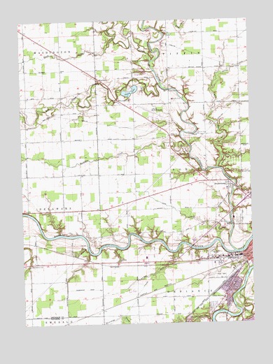
Defiance West, OH USGS Topographic Map
Click on map above to begin viewing in our Map Viewer.

This topographic map contains these locations and features:
Feature Name Type Latitude Longitude GNIS ID View Map
Anthony Wayne Elementary SchoolSchoolN41.2603°W84.3899°1081015View Map
Ashwood (historical)Populated PlaceN41.2559°W84.4572°1057292View Map
Ashwood Post Office (historical)Post OfficeN41.2556°W84.4569°1983547View Map
Black CreekStreamN41.3676°W84.4488°1038073View Map
Bohlmanns Trailer ParkPopulated PlaceN41.2756°W84.4053°2680200View Map
Bronson ParkParkN41.2559°W84.3924°1055110View Map
BrunersburgPopulated PlaceN41.3067°W84.3869°1060900View Map
Brunersburg CemeteryCemeteryN41.3078°W84.3819°1961346View Map
Brunersburg Post Office (historical)Post OfficeN41.3070°W84.3874°1983557View Map
Buckskin CreekStreamN41.3195°W84.4083°1038487View Map
Camp LacotaLocaleN41.2564°W84.3799°1055111View Map
Camp Lakota Boy Scout Lake DamDamN41.2500°W84.3799°1078296View Map
Catholic Cemetery (historical)CemeteryN41.2781°W84.3847°1806047View Map
Church of ChristChurchN41.2589°W84.3922°1065595View Map
Cooks Rolling HillsPopulated PlaceN41.3031°W84.3778°2680199View Map
Defiance CountyCivilN41.3239°W84.4905°1074032View Map
Defiance County Children Home CemeteryCemeteryN41.3459°W84.4213°1806048View Map
Defiance County HomeBuildingN41.3423°W84.4169°1055116View Map
Defiance County Home CemeteryCemeteryN41.3403°W84.4216°1961347View Map
Defiance Memorial AirportAirportN41.3348°W84.4283°1082647View Map
Defiance Regional Medical CenterHospitalN41.2985°W84.3766°2548849View Map
Defiance Water Treatment PlantLocaleN41.2781°W84.3847°2740844View Map
Dowe DitchCanalN41.2959°W84.4144°1039772View Map
Glenwood School (historical)SchoolN41.2662°W84.3852°1079634View Map
Hill CemeteryCemeteryN41.2826°W84.4688°1961348View Map
Kibble CemeteryCemeteryN41.3587°W84.4393°1042250View Map
Kingdom Hall of Jehovahs WitnessesChurchN41.2578°W84.3924°1065611View Map
Legion FieldParkN41.2720°W84.3838°1055136View Map
Lick CreekStreamN41.3584°W84.4291°1042527View Map
M and M Medivan AmbulanceBuildingN41.3086°W84.4014°2550952View Map
Marysdale Catholic CemeteryCemeteryN41.3500°W84.4580°1806051View Map
Marysdale ChurchChurchN41.3506°W84.4577°1043043View Map
McCauley CemeteryCemeteryN41.3698°W84.4202°1043087View Map
Medcorp Emergency Medical ServicesBuildingN41.3086°W84.3975°2550921View Map
Millers Rolling Hills EstatesPopulated PlaceN41.3036°W84.3758°2680201View Map
Mud CreekStreamN41.3487°W84.4241°1066103View Map
Noble and Tiffin CemeteryCemeteryN41.3281°W84.4044°1043887View Map
Noble Township Elementary SchoolSchoolN41.3053°W84.3880°1055127View Map
Noble Township Fire DepartmentBuildingN41.3087°W84.3884°2549725View Map
Ohio State Highway Patrol - Defiance Patrol PostBuildingN41.2759°W84.4152°2733107View Map
Olive Branch ChurchChurchN41.3423°W84.4469°1044159View Map
Oxbow LakeReservoirN41.3448°W84.4400°1070887View Map
Oxbow Lake DamDamN41.3434°W84.4416°1078736View Map
Oxbow Lake State Wildlife AreaParkN41.3456°W84.4388°1083457View Map
Powell CreekStreamN41.2550°W84.3811°1066151View Map
Riverside CemeteryCemeteryN41.2714°W84.3786°1048364View Map
Saint Stephens CemeteryCemeteryN41.2748°W84.4956°1045827View Map
Shoemaker CemeteryCemeteryN41.2756°W84.4474°1046235View Map
Short Trailer ParkPopulated PlaceN41.2761°W84.4075°2680205View Map
Stevens DitchCanalN41.2706°W84.4283°1046681View Map
Tecumseh ParkParkN41.2684°W84.3822°1055132View Map
Threemile CreekStreamN41.2514°W84.3972°1066235View Map
Tiffin RiverStreamN41.2792°W84.3844°1079969View Map
Township of NobleCivilN41.3122°W84.4008°1086037View Map
Webb RunStreamN41.3139°W84.3933°1047648View Map
WONW-AM (Defiance)TowerN41.2789°W84.3972°1083720View Map

Note: Coordinates in the location and feature list above are referenced to NAD83 datum.


Copyright (C) 2008-2024 Ryan Niemi / Sunset Dynamics ... All Rights Reserved