TopoQuest Logo
Do you find TopoQuest useful?
Help keep TopoQuest running and adding new maps/features by donating!
Bitcoin:  19c7KJd3qBynnjoSw5npx9KScwjBe4ifkT
Litecoin:  LXs6TkuXGGXo1vDsWCkWVdjQX94eUKd6ui
Home View Maps Find Maps Find Places Resources & Links


Denman, Nebraska Topographic Map

USGS Map Title: Denman, NE
USGS Map MRC: 40098F6
DRG (GeoTIFF) Download: o40098f6.tif


Neighboring USGS Topographic Map Quads:


  Gibbon North, NE  
40098G7
 

  Shelton, NE  
40098G6
 

  Wood River, NE  
40098G5
 

  Gibbon South, NE  
40098F7
 

  Denman, NE  
40098F6
 

  Prosser, NE  
40098F5
 

  Heartwell, NE  
40098E7
 

  Kenesaw, NE  
40098E6
 

  Juniata, NE  
40098E5


Map MRC Location:

N41°
W99°
N41°
W98°
H8 H7 H6 H5 H4 H3 H2 H1
G8 G7 G6 G5 G4 G3 G2 G1
F8 F7 F6 F5 F4 F3 F2 F1
E8 E7 E6 E5 E4 E3 E2 E1
D8 D7 D6 D5 D4 D3 D2 D1
C8 C7 C6 C5 C4 C3 C2 C1
B8 B7 B6 B5 B4 B3 B2 B1
A8 A7 A6 A5 A4 A3 A2 A1
N40°
W99°
N40°
W98°

Denman, NE USGS 1:24K Topographic Map Preview:
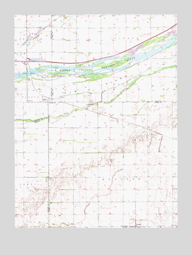
Denman, NE USGS Topographic Map
Click on map above to begin viewing in our Map Viewer.

This topographic map contains these locations and features:
Feature Name Type Latitude Longitude GNIS ID View Map
DenmanLocaleN40.7011°W98.7245°1875118View Map
DenmanPopulated PlaceN40.6995°W98.7245°828674View Map
Denman Island State Wildlife Management AreaParkN40.7139°W98.7201°1794631View Map
Denman Post Office (historical)Post OfficeN40.6995°W98.7245°1875116View Map
Denman School (historical)SchoolN40.6997°W98.7248°1875117View Map
Dry CreekStreamN40.7006°W98.6737°828816View Map
Hannon Federal Waterfowl Production AreaParkN40.7389°W98.6920°1874101View Map
Interchange 291CrossingN40.7228°W98.7409°1875364View Map
Martins Reach State Wildlife Management AreaParkN40.7389°W98.6295°1874100View Map
School Number 1SchoolN40.6689°W98.7437°836101View Map
School Number 37SchoolN40.7278°W98.7373°836639View Map
Susan O Hail Grave Historical MarkerParkN40.6542°W98.7226°1884571View Map
Township of KenesawCivilN40.6551°W98.6672°838077View Map
War Axe State Recreation AreaParkN40.7236°W98.7337°1794630View Map

Note: Coordinates in the location and feature list above are referenced to NAD83 datum.


Copyright (C) 2008-2025 Ryan Niemi / Sunset Dynamics ... All Rights Reserved