TopoQuest Logo
Do you find TopoQuest useful?
Help keep TopoQuest running and adding new maps/features by donating!
Bitcoin:  19c7KJd3qBynnjoSw5npx9KScwjBe4ifkT
Litecoin:  LXs6TkuXGGXo1vDsWCkWVdjQX94eUKd6ui
Home View Maps Find Maps Find Places Resources & Links


Dennis, Texas Topographic Map

USGS Map Title: Dennis, TX
USGS Map MRC: 32097E8
DRG (GeoTIFF) Download: o32097e8.tif


Neighboring USGS Topographic Map Quads:


  Brazos East, TX  
32098F1
 

  Brock, TX  
32097F8
 

  Weatherford South, TX  
32097F7
 

  Lipan, TX  
32098E1
 

  Dennis, TX  
32097E8
 

  Tin Top, TX  
32097E7
 

  Bluff Dale NE, TX  
32098D1
 

  Tolar, TX  
32097D8
 

  Granbury, TX  
32097D7


Map MRC Location:

N33°
W98°
N33°
W97°
H8 H7 H6 H5 H4 H3 H2 H1
G8 G7 G6 G5 G4 G3 G2 G1
F8 F7 F6 F5 F4 F3 F2 F1
E8 E7 E6 E5 E4 E3 E2 E1
D8 D7 D6 D5 D4 D3 D2 D1
C8 C7 C6 C5 C4 C3 C2 C1
B8 B7 B6 B5 B4 B3 B2 B1
A8 A7 A6 A5 A4 A3 A2 A1
N32°
W98°
N32°
W97°

Dennis, TX USGS 1:24K Topographic Map Preview:
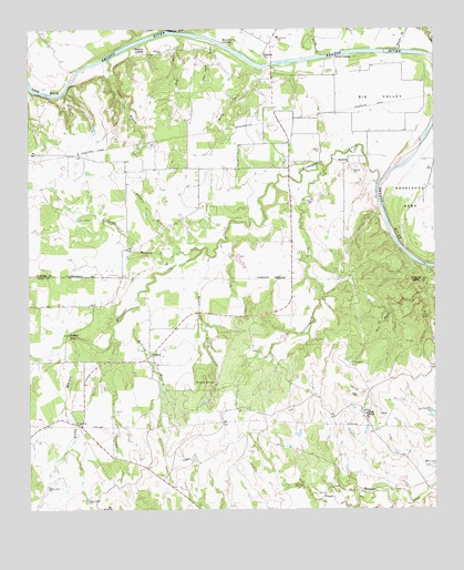
Dennis, TX USGS Topographic Map
Click on map above to begin viewing in our Map Viewer.

This topographic map contains these locations and features:
Feature Name Type Latitude Longitude GNIS ID View Map
Aldenhoven Lake DamDamN32.5001°W97.9720°1864329View Map
AllisonPopulated PlaceN32.5404°W97.9625°1377924View Map
Big ValleyBendN32.6087°W97.8875°1330675View Map
Bigwater BranchStreamN32.6196°W97.8859°1330682View Map
Black Lake Number 2ReservoirN32.5035°W97.9203°1864318View Map
Black Lake Number 2 DamDamN32.5035°W97.9203°1864317View Map
Black Lake Number 3ReservoirN32.5151°W97.8842°1864320View Map
Black Lake Number 3 DamDamN32.5151°W97.8853°1864319View Map
Black Lake Number 4ReservoirN32.5318°W97.8753°1864322View Map
Black Lake Number 4 DamDamN32.5318°W97.8753°1864321View Map
Black RanchLocaleN32.5249°W97.8970°1330781View Map
Brock - Dennis Volunteer Fire Department Station 2BuildingN32.5980°W97.9198°2551697View Map
BucknerPopulated PlaceN32.5899°W97.9025°1378064View Map
Buckner CemeteryCemeteryN32.5876°W97.8998°1331514View Map
Cottonwood CreekStreamN32.5882°W97.9086°1333449View Map
Cougar BranchStreamN32.6174°W97.9748°1333497View Map
Crow BranchStreamN32.5007°W97.9011°1333735View Map
DennisPopulated PlaceN32.6187°W97.9267°1334253View Map
Dennis Post OfficePost OfficeN32.6205°W97.9260°2731589View Map
Dripping SpringsSpringN32.5333°W97.9437°1334621View Map
Dripping SpringsSpringN32.5418°W97.9586°1998588View Map
First Baptist Church of Horseshoe BendChurchN32.5790°W97.8756°2023835View Map
Holder CemeteryCemeteryN32.5932°W97.9100°1337925View Map
Horseshoe BendBendN32.5804°W97.8773°1374150View Map
Horseshoe Bend Census Designated PlaceCensusN32.5752°W97.8782°2586939View Map
Horseshoe Bend Volunteer Fire Department Station Number 3BuildingN32.5837°W97.8770°2551700View Map
Kickapoo CreekStreamN32.5837°W97.8925°1339083View Map
Kickapoo FallsFallsN32.5454°W97.9878°1339084View Map
Killing BranchStreamN32.5529°W97.9667°1339108View Map
Lazy BendBendN32.6101°W97.9950°1339748View Map
Little Onion BranchStreamN32.6218°W97.9428°1340145View Map
Maxwell CrossingPopulated PlaceN32.6210°W97.9373°1378652View Map
Moccasin BranchStreamN32.5676°W97.9536°1341779View Map
Onion BranchStreamN32.5674°W97.9467°1343281View Map
Patrick CreekStreamN32.6182°W97.9106°1343665View Map
Powell CrossingPopulated PlaceN32.6179°W97.9053°1378903View Map
Red Bank CreekStreamN32.5629°W97.8761°1344883View Map
Rocky BranchStreamN32.5449°W97.9853°1345437View Map
Rocky RunStreamN32.6146°W97.9275°1345492View Map
Stephens CemeteryCemeteryN32.6193°W97.9584°1347887View Map
Stephens CrossingPopulated PlaceN32.6187°W97.9645°1379111View Map
Wash BranchStreamN32.6232°W97.9517°1349508View Map
Waters BranchStreamN32.5660°W97.9442°1349543View Map

Note: Coordinates in the location and feature list above are referenced to NAD83 datum.


Copyright (C) 2008-2025 Ryan Niemi / Sunset Dynamics ... All Rights Reserved