TopoQuest Logo
Do you find TopoQuest useful?
Help keep TopoQuest running and adding new maps/features by donating!
Bitcoin:  19c7KJd3qBynnjoSw5npx9KScwjBe4ifkT
Litecoin:  LXs6TkuXGGXo1vDsWCkWVdjQX94eUKd6ui
Home View Maps Find Maps Find Places Resources & Links


Tin Top, Texas Topographic Map

USGS Map Title: Tin Top, TX
USGS Map MRC: 32097E7
DRG (GeoTIFF) Download: o32097e7.tif


Neighboring USGS Topographic Map Quads:


  Brock, TX  
32097F8
 

  Weatherford South, TX  
32097F7
 

  Annetta, TX  
32097F6
 

  Dennis, TX  
32097E8
 

  Tin Top, TX  
32097E7
 

  Chapin, TX  
32097E6
 

  Tolar, TX  
32097D8
 

  Granbury, TX  
32097D7
 

  Acton, TX  
32097D6


Map MRC Location:

N33°
W98°
N33°
W97°
H8 H7 H6 H5 H4 H3 H2 H1
G8 G7 G6 G5 G4 G3 G2 G1
F8 F7 F6 F5 F4 F3 F2 F1
E8 E7 E6 E5 E4 E3 E2 E1
D8 D7 D6 D5 D4 D3 D2 D1
C8 C7 C6 C5 C4 C3 C2 C1
B8 B7 B6 B5 B4 B3 B2 B1
A8 A7 A6 A5 A4 A3 A2 A1
N32°
W98°
N32°
W97°

Tin Top, TX USGS 1:24K Topographic Map Preview:
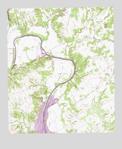
Tin Top, TX USGS Topographic Map
Click on map above to begin viewing in our Map Viewer.

This topographic map contains these locations and features:
Feature Name Type Latitude Longitude GNIS ID View Map
Black LakeReservoirN32.5113°W97.8738°1862045View Map
Black Lake DamDamN32.5101°W97.8720°1862044View Map
Black Lake Number 5ReservoirN32.5214°W97.8725°1864324View Map
Black Lake Number 5 DamDamN32.5201°W97.8720°1864323View Map
Black Lake Number 6ReservoirN32.5298°W97.8636°1864326View Map
Black Lake Number 6 DamDamN32.5285°W97.8636°1864325View Map
Blair ValleyBendN32.5851°W97.8514°1330822View Map
Campbell IslandIslandN32.5787°W97.8345°1332036View Map
Center MillPopulated PlaceN32.5540°W97.7645°1378108View Map
Cidwell BranchStreamN32.5924°W97.7945°1373111View Map
Conway BluffCliffN32.5668°W97.8686°1333259View Map
Driftwood Ranch AirportAirportN32.5636°W97.8062°2676599View Map
FairviewPopulated PlaceN32.5149°W97.8017°1378282View Map
Fairview Baptist ChurchChurchN32.5326°W97.7900°2020867View Map
Fairview CemeteryCemeteryN32.5024°W97.7984°1335627View Map
Fairview ChurchChurchN32.5112°W97.7973°1335638View Map
Hart BranchStreamN32.6115°W97.8270°1374013View Map
Haydon CreekStreamN32.6246°W97.7786°1384274View Map
Herring CemeteryCemeteryN32.5104°W97.8434°1337657View Map
Hightower BridgeBridgeN32.5765°W97.8223°1337759View Map
Hightower ValleyBendN32.5607°W97.8109°1337762View Map
Horsehoe Bend CemeteryCemeteryN32.6037°W97.8611°1338113View Map
Horseshoe Bend AirportAirportN32.5729°W97.8725°1387726View Map
Horseshoe LakeReservoirN32.6218°W97.8103°1862676View Map
Horseshoe Lake DamDamN32.6218°W97.8103°1862675View Map
Jacobs BranchStreamN32.5518°W97.8039°1338610View Map
Long CreekStreamN32.5243°W97.8311°1340449View Map
Martin BranchStreamN32.5510°W97.7556°1384253View Map
McCuan BranchStreamN32.5421°W97.8228°1341175View Map
Mill CreekStreamN32.6240°W97.8336°1374948View Map
Milliken BluffCliffN32.6171°W97.8736°1341683View Map
Mud CreekStreamN32.5618°W97.7961°1342191View Map
Nebo MountainSummitN32.6068°W97.7603°1375102View Map
New Prospect ChurchChurchN32.5954°W97.8117°1342504View Map
Parker County Emergency Services District No. 6 - TimtopBuildingN32.6124°W97.8031°2551733View Map
Peveler ValleyBendN32.5146°W97.8264°1343925View Map
Robinson CreekStreamN32.5027°W97.8448°1345335View Map
Sanchez CreekStreamN32.5924°W97.8345°1375981View Map
Shaw CreekStreamN32.6104°W97.7806°1384277View Map
Spring CreekStreamN32.5743°W97.8070°1347723View Map
Stark Field Airport (historical)AirportN32.5696°W97.7531°1386749View Map
Temple Hall ChurchChurchN32.5490°W97.7553°1348353View Map
Tin TopPopulated PlaceN32.5976°W97.8131°1379164View Map
Tin Top Suspension BridgeBridgeN32.5757°W97.8220°2031641View Map
Turkey CreekStreamN32.5587°W97.7973°1348861View Map
Walker BranchStreamN32.5974°W97.8567°1376611View Map
Western LakeReservoirN32.6168°W97.8153°1862678View Map
Western LakePopulated PlaceN32.6234°W97.8116°2033799View Map
Western Lake Census Designated PlaceCensusN32.6215°W97.8160°2587002View Map
Western Lake DamDamN32.6168°W97.8153°1862677View Map

Note: Coordinates in the location and feature list above are referenced to NAD83 datum.


Copyright (C) 2008-2025 Ryan Niemi / Sunset Dynamics ... All Rights Reserved