TopoQuest Logo
Do you find TopoQuest useful?
Help keep TopoQuest running and adding new maps/features by donating!
Bitcoin:  19c7KJd3qBynnjoSw5npx9KScwjBe4ifkT
Litecoin:  LXs6TkuXGGXo1vDsWCkWVdjQX94eUKd6ui
Home View Maps Find Maps Find Places Resources & Links


Granbury, Texas Topographic Map

USGS Map Title: Granbury, TX
USGS Map MRC: 32097D7
DRG (GeoTIFF) Download: o32097d7.tif


Neighboring USGS Topographic Map Quads:


  Dennis, TX  
32097E8
 

  Tin Top, TX  
32097E7
 

  Chapin, TX  
32097E6
 

  Tolar, TX  
32097D8
 

  Granbury, TX  
32097D7
 

  Acton, TX  
32097D6
 

  Paluxy, TX  
32097C8
 

  Hill City, TX  
32097C7
 

  Nemo, TX  
32097C6


Map MRC Location:

N33°
W98°
N33°
W97°
H8 H7 H6 H5 H4 H3 H2 H1
G8 G7 G6 G5 G4 G3 G2 G1
F8 F7 F6 F5 F4 F3 F2 F1
E8 E7 E6 E5 E4 E3 E2 E1
D8 D7 D6 D5 D4 D3 D2 D1
C8 C7 C6 C5 C4 C3 C2 C1
B8 B7 B6 B5 B4 B3 B2 B1
A8 A7 A6 A5 A4 A3 A2 A1
N32°
W98°
N32°
W97°

Granbury, TX USGS 1:24K Topographic Map Preview:
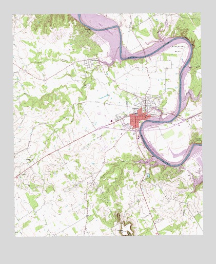
Granbury, TX USGS Topographic Map
Click on map above to begin viewing in our Map Viewer.

This topographic map contains these locations and features:
Feature Name Type Latitude Longitude GNIS ID View Map
Bee CreekStreamN32.4829°W97.7739°1330328View Map
Blue BranchStreamN32.4665°W97.8234°1330896View Map
Bowser LakeReservoirN32.4090°W97.7863°1864402View Map
Bowser Lake DamDamN32.4101°W97.7870°1864401View Map
Brazos BendPopulated PlaceN32.4773°W97.7629°2083667View Map
BrushyPopulated PlaceN32.3865°W97.8270°1378061View Map
Brushy CemeteryCemeteryN32.4007°W97.8223°1331416View Map
Camp CrucisLocaleN32.4604°W97.8270°1331968View Map
Camp KlebitLocaleN32.4718°W97.8231°1331980View Map
Cedar BluffCliffN32.4840°W97.7575°1332375View Map
Christian Science Society Granbury ChurchChurchN32.4232°W97.7914°2020876View Map
Church of the NazareneChurchN32.4701°W97.8159°2020879View Map
City of Brazos BendCivilN32.4752°W97.7610°2409895View Map
City of GranburyCivilN32.4409°W97.7941°2410629View Map
Comanche Harbor LakeReservoirN32.4089°W97.7695°1863055View Map
Comanche Harbor Lake DamDamN32.4085°W97.7686°1863054View Map
Comanche PeakSummitN32.3774°W97.8034°1333174View Map
Eden BranchStreamN32.4707°W97.7600°1335082View Map
Emma Roberson Elementary SchoolSchoolN32.4268°W97.8003°2006378View Map
Fall BranchStreamN32.4182°W97.7798°1335673View Map
First Baptist ChurchChurchN32.4399°W97.8028°2020868View Map
Friendship SchoolSchoolN32.4179°W97.8645°1336250View Map
Granburry City ParkParkN32.4437°W97.8000°2028267View Map
GranburyPopulated PlaceN32.4421°W97.7942°1336797View Map
Granbury Behavior Transition CenterSchoolN32.4462°W97.7878°2006379View Map
Granbury CemeteryCemeteryN32.4532°W97.7856°1336798View Map
Granbury City HallBuildingN32.4438°W97.7883°2753695View Map
Granbury High SchoolSchoolN32.4376°W97.8128°2006380View Map
Granbury Intermediate SchoolSchoolN32.4435°W97.7936°2006381View Map
Granbury Middle SchoolSchoolN32.4451°W97.7959°2006382View Map
Granbury Police DepartmentBuildingN32.4438°W97.7882°2738942View Map
Granbury Post OfficePost OfficeN32.4474°W97.7858°2731172View Map
Granbury Regional AirportAirportN32.4461°W97.8169°1386748View Map
Granbury Volunteer Fire Department Station 1BuildingN32.4397°W97.8049°2551415View Map
Granbury Volunteer Fire Department Station 2BuildingN32.4390°W97.7514°2551605View Map
Hood CountyCivilN32.4299°W97.8323°1383896View Map
Hood County Constable's Office Precinct 1BuildingN32.4427°W97.8022°2739102View Map
Hood County Constable's Office Precinct 2BuildingN32.4426°W97.8025°2739159View Map
Hood County Constable's Office Precinct 4BuildingN32.4427°W97.7871°2739066View Map
Hood County Courthouse Historic DistrictLocaleN32.4437°W97.7828°2032089View Map
Hood County JailBuildingN32.4445°W97.8050°2738700View Map
Hood County Sheriff's OfficeBuildingN32.4445°W97.8047°2739052View Map
Hood County Volunteer Fire Department Station 70BuildingN32.4888°W97.8440°2551404View Map
Indian Harbor Volunteer Fire Department and First RespondersBuildingN32.4108°W97.7619°2551405View Map
KPAR-AM (Granbury)TowerN32.4621°W97.7889°1385573View Map
Lake GranburyReservoirN32.4783°W97.8028°1377202View Map
Lake Granbury Medical CenterHospitalN32.4324°W97.8037°2015788View Map
Lakeside Baptist ChurchChurchN32.4165°W97.7881°2020871View Map
Lambert BranchStreamN32.4393°W97.7764°1339585View Map
Nettie Baccus Elementary SchoolSchoolN32.4679°W97.7978°2006387View Map
North Hood County Volunteer Fire DepartmentBuildingN32.4925°W97.7786°2551427View Map
Oak Trail ShoresPopulated PlaceN32.4887°W97.8342°1867558View Map
Oak Trail Shores Census Designated PlaceCensusN32.4885°W97.8357°2408965View Map
Our Savior Lutheran ChurchChurchN32.4321°W97.7773°2020881View Map
Paluxy Road Church of ChristChurchN32.4235°W97.8123°2020878View Map
Peveler ValleyBendN32.4946°W97.8211°1343924View Map
Pirate StadiumParkN32.4376°W97.8128°2027732View Map
Rough CreekStreamN32.4196°W97.7825°1345637View Map
Rucker CreekStreamN32.4499°W97.7642°1345738View Map
Seventh Day Adventist ChurchChurchN32.4393°W97.7531°2020883View Map
South Fork Strouds CreekStreamN32.4568°W97.8295°1347460View Map
Southside Baptist ChurchChurchN32.4354°W97.7978°2020873View Map
Stockton BendBendN32.4796°W97.7645°1347948View Map
Strouds CreekStreamN32.4812°W97.8048°1348011View Map
Texas Emergency Medical ServicesBuildingN32.4364°W97.8110°2655901View Map
Texas Forest Service Granbury OfficeBuildingN32.4465°W97.8164°2551741View Map
Thompson MountainSummitN32.4904°W97.8259°1348508View Map
Thorp SpringPopulated PlaceN32.4740°W97.8267°1348515View Map
Thorp Spring CemeteryCemeteryN32.4657°W97.8264°1348516View Map
Thorp SpringsSpringN32.4751°W97.8253°1998529View Map
Vineyard Baptist ChurchChurchN32.4424°W97.7906°2020874View Map
Wright-Henderson-Duncan HouseBuildingN32.4354°W97.7950°2032394View Map

Note: Coordinates in the location and feature list above are referenced to NAD83 datum.


Copyright (C) 2008-2025 Ryan Niemi / Sunset Dynamics ... All Rights Reserved