TopoQuest Logo
Do you find TopoQuest useful?
Help keep TopoQuest running and adding new maps/features by donating!
Bitcoin:  19c7KJd3qBynnjoSw5npx9KScwjBe4ifkT
Litecoin:  LXs6TkuXGGXo1vDsWCkWVdjQX94eUKd6ui
Home View Maps Find Maps Find Places Resources & Links


DeRuyter, New York Topographic Map

USGS Map Title: DeRuyter, NY
USGS Map MRC: 42075G8
DRG (GeoTIFF) Download: o42075g8.tif


Neighboring USGS Topographic Map Quads:


  Jamesville, NY  
42076H1
 

  Oran, NY  
42075H8
 

  Cazenovia, NY  
42075H7
 

  Tully, NY  
42076G1
 

  DeRuyter, NY  
42075G8
 

  Erieville, NY  
42075G7
 

  Truxton, NY  
42076F1
 

  Cuyler, NY  
42075F8
 

  South Otselic, NY  
42075F7


Map MRC Location:

N43°
W76°
N43°
W75°
H8 H7 H6 H5 H4 H3 H2 H1
G8 G7 G6 G5 G4 G3 G2 G1
F8 F7 F6 F5 F4 F3 F2 F1
E8 E7 E6 E5 E4 E3 E2 E1
D8 D7 D6 D5 D4 D3 D2 D1
C8 C7 C6 C5 C4 C3 C2 C1
B8 B7 B6 B5 B4 B3 B2 B1
A8 A7 A6 A5 A4 A3 A2 A1
N42°
W76°
N42°
W75°

DeRuyter, NY USGS 1:24K Topographic Map Preview:
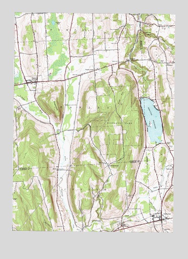
DeRuyter, NY USGS Topographic Map
Click on map above to begin viewing in our Map Viewer.

This topographic map contains these locations and features:
Feature Name Type Latitude Longitude GNIS ID View Map
Albro CemeteryCemeteryN42.7573°W75.9173°2541921View Map
Arab HillSummitN42.8226°W75.9160°942530View Map
Barbland FarmsLocaleN42.8353°W75.9472°2547252View Map
Beach CemeteryCemeteryN42.8581°W75.9201°943219View Map
Burdick CemeteryCemeteryN42.7993°W75.8790°945201View Map
Carpenter CreekStreamN42.8403°W75.9574°945886View Map
Carpenter PondLakeN42.8692°W75.9697°945890View Map
Cowles SettlementPopulated PlaceN42.7881°W75.9258°972349View Map
De Ruyter Town HallBuildingN42.7590°W75.8847°2598924View Map
Delphi CemeteryCemeteryN42.8689°W75.9121°948281View Map
Delphi FallsFallsN42.8642°W75.8994°970066View Map
DeRuyterPopulated PlaceN42.7584°W75.8844°948102View Map
DeRuyter ReservoirReservoirN42.8145°W75.8923°948103View Map
East Branch Limestone CreekStreamN42.8695°W75.9030°970094View Map
East Branch Tioughnioga CreekStreamN42.7701°W75.8963°949017View Map
FabiusPopulated PlaceN42.8351°W75.9860°949793View Map
Fabius - Pompey Elementary SchoolSchoolN42.8344°W75.9860°2668843View Map
Fabius - Pompey Middle - High SchoolSchoolN42.8290°W75.9860°2669017View Map
Fabius Baptist ChurchChurchN42.8353°W75.9861°2542256View Map
Fabius BrookStreamN42.8009°W75.9610°977528View Map
Fabius Evergreen CemeteryCemeteryN42.8314°W75.9839°2542257View Map
Fabius Fire DepartmentBuildingN42.8354°W75.9850°2700924View Map
Gooseville CornersLocaleN42.8481°W75.9102°951385View Map
Hills CreekStreamN42.7556°W75.9310°952828View Map
HogsbackSummitN42.8198°W75.9674°952966View Map
KeeneyPopulated PlaceN42.7851°W75.9649°954434View Map
Keeney Settlement CemeteryCemeteryN42.7870°W75.9654°2541916View Map
Lee CemeteryCemeteryN42.7511°W75.9483°2541919View Map
Merchant Smith CemeteryCemeteryN42.7965°W75.8942°965463View Map
Middle Branch Tioughnioga CreekStreamN42.7701°W75.8963°957086View Map
Morgan HillSummitN42.7853°W75.9933°942072View Map
Old Fabius CemeteryCemeteryN42.8358°W75.9862°2542255View Map
PuckervillePopulated PlaceN42.7867°W75.8755°961936View Map
Saint Lawrence ChurchChurchN42.7567°W75.8852°2597874View Map
School Number 1 (historical)SchoolN42.8398°W75.9494°974905View Map
School Number 11 (historical)SchoolN42.7892°W75.9277°974986View Map
School Number 15 (historical)SchoolN42.8070°W75.9633°975109View Map
School Number 3 (historical)SchoolN42.8009°W75.8807°975267View Map
School Number 5 (historical)SchoolN42.7698°W75.9071°975416View Map
School Number 5 (historical)SchoolN42.7851°W75.9646°975418View Map
School Number 7 (historical)SchoolN42.7540°W75.9149°975540View Map
School Number 7 (historical)SchoolN42.8206°W75.9935°975544View Map
School Number 8 (historical)SchoolN42.7528°W75.9596°975590View Map
School Number 8 (historical)SchoolN42.8470°W75.8866°975592View Map
School Number 8 (historical)SchoolN42.8476°W75.9183°975593View Map
Smith Ambulance ServiceBuildingN42.7574°W75.8856°2720203View Map
Stockham HillSummitN42.8698°W75.9413°966468View Map
Stockham Hill CemeteryCemeteryN42.8406°W75.9371°2542258View Map
The GulfValleyN42.8709°W75.9046°967256View Map
The Old FlyStreamN42.8267°W75.9944°977536View Map
Three Sisters FarmLocaleN42.8717°W75.9569°2547251View Map
Town of FabiusCivilN42.8220°W75.9912°978949View Map
UnionPopulated PlaceN42.8678°W75.8871°973176View Map
Union CemeteryCemeteryN42.8668°W75.8849°968163View Map
United Church of DeRuyterChurchN42.7555°W75.8881°2597881View Map
Village of DeRuyterCivilN42.7587°W75.8867°2391641View Map
Village of FabiusCivilN42.8347°W75.9847°2390830View Map
Vincent CornersLocaleN42.8423°W75.9374°968560View Map
West WoodstockPopulated PlaceN42.8470°W75.8816°973254View Map

Note: Coordinates in the location and feature list above are referenced to NAD83 datum.


Copyright (C) 2008-2025 Ryan Niemi / Sunset Dynamics ... All Rights Reserved