TopoQuest Logo
Do you find TopoQuest useful?
Help keep TopoQuest running and adding new maps/features by donating!
Bitcoin:  19c7KJd3qBynnjoSw5npx9KScwjBe4ifkT
Litecoin:  LXs6TkuXGGXo1vDsWCkWVdjQX94eUKd6ui
Home View Maps Find Maps Find Places Resources & Links


Tully, New York Topographic Map

USGS Map Title: Tully, NY
USGS Map MRC: 42076G1
DRG (GeoTIFF) Download: o42076g1.tif


Neighboring USGS Topographic Map Quads:


  South Onondaga, NY  
42076H2
 

  Jamesville, NY  
42076H1
 

  Oran, NY  
42075H8
 

  Otisco Valley, NY  
42076G2
 

  Tully, NY  
42076G1
 

  DeRuyter, NY  
42075G8
 

  Homer, NY  
42076F2
 

  Truxton, NY  
42076F1
 

  Cuyler, NY  
42075F8


Map MRC Location:

N43°
W77°
N43°
W76°
H8 H7 H6 H5 H4 H3 H2 H1
G8 G7 G6 G5 G4 G3 G2 G1
F8 F7 F6 F5 F4 F3 F2 F1
E8 E7 E6 E5 E4 E3 E2 E1
D8 D7 D6 D5 D4 D3 D2 D1
C8 C7 C6 C5 C4 C3 C2 C1
B8 B7 B6 B5 B4 B3 B2 B1
A8 A7 A6 A5 A4 A3 A2 A1
N42°
W77°
N42°
W76°

Tully, NY USGS 1:24K Topographic Map Preview:
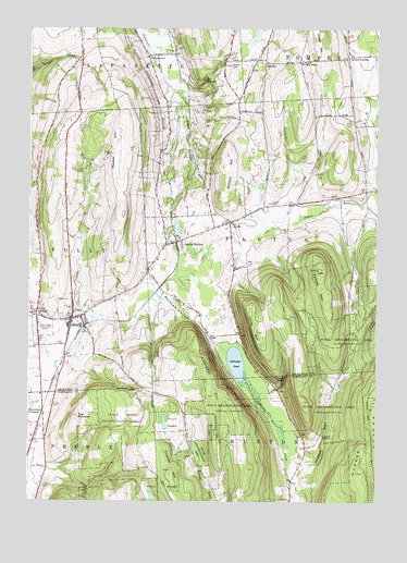
Tully, NY USGS Topographic Map
Click on map above to begin viewing in our Map Viewer.

This topographic map contains these locations and features:
Feature Name Type Latitude Longitude GNIS ID View Map
ApuliaPopulated PlaceN42.8240°W76.0535°942058View Map
Apulia CemeteryCemeteryN42.8286°W76.0380°942059View Map
Apulia Fire DepartmentBuildingN42.8171°W76.0775°2701165View Map
Apulia StationPopulated PlaceN42.8187°W76.0724°942060View Map
Apulia United Methodist ChurchChurchN42.8188°W76.0714°2615540View Map
BerwynPopulated PlaceN42.8662°W76.0408°972227View Map
Cascades CreekStreamN42.8701°W76.0833°977525View Map
Chase HillSummitN42.8723°W76.0227°942062View Map
Clark HollowValleyN42.8615°W76.0738°977526View Map
CollingwoodPopulated PlaceN42.8676°W76.0830°942063View Map
Cummings CrossingPopulated PlaceN42.7740°W76.1194°972358View Map
Fellows HillSummitN42.8112°W76.0213°942064View Map
Hill - N - Dale Country ClubLocaleN42.8146°W76.0748°2615414View Map
Jerome CornersLocaleN42.8676°W76.0108°942065View Map
Jones HillSummitN42.7948°W76.0427°942066View Map
Labrador HillSummitN42.7778°W76.0585°942067View Map
Labrador PondLakeN42.7866°W76.0504°942068View Map
Maplewood Rural CemeteryCemeteryN42.8654°W76.0532°942061View Map
Markham HollowValleyN42.8131°W76.0710°977531View Map
Matson HillSummitN42.8417°W76.0544°942069View Map
Meeker CemeteryCemeteryN42.8420°W76.0963°942070View Map
Meeker HillSummitN42.8262°W76.0916°942071View Map
Miles CemeteryCemeteryN42.8125°W76.0824°2542254View Map
Old Tully CemeteryCemeteryN42.7826°W76.1206°2542252View Map
Palladino PitMineN42.8058°W76.0567°2548807View Map
Saint Leo's Catholic ChurchChurchN42.7961°W76.1088°2616953View Map
Saint Leo's CemeteryCemeteryN42.7756°W76.1163°942076View Map
School Number 12 (historical)SchoolN42.7672°W76.1186°2123390View Map
School Number 17 (historical)SchoolN42.8667°W76.0408°2359293View Map
School Number 2 (historical)SchoolN42.8444°W76.0408°2359291View Map
School Number 4 (historical)SchoolN42.8175°W76.0767°2359292View Map
Shackham BrookStreamN42.7606°W76.0319°977535View Map
Sherman Hollow CemeteryCemeteryN42.8653°W76.0818°2542253View Map
State Reforestation AreaForestN42.7951°W76.0158°942077View Map
State Reforestation AreaForestN42.7742°W76.0227°942085View Map
Stump Pond (historical)LakeN42.8217°W76.0717°2359290View Map
Swift CornerPopulated PlaceN42.8665°W76.0285°973133View Map
The CascadesFallsN42.8617°W76.0630°942079View Map
The PinnacleSummitN42.7723°W76.1074°942080View Map
Thermal Ridge GliderportAirportN42.7553°W76.1230°978245View Map
Tinker FallsFallsN42.7833°W76.0326°942081View Map
Truxton HillSummitN42.7573°W76.0738°942086View Map
TullyPopulated PlaceN42.7981°W76.1094°942082View Map
Tully CemeteryCemeteryN42.7917°W76.1131°2542251View Map
Tully CenterPopulated PlaceN42.7990°W76.1221°942083View Map
Tully Elementary SchoolSchoolN42.7962°W76.1111°2668922View Map
Tully Fire DepartmentBuildingN42.7986°W76.1057°2701026View Map
Tully ForestForestN42.7623°W76.0958°942087View Map
Tully Free LibraryBuildingN42.7972°W76.1102°2617445View Map
Tully Junior - Senior High SchoolSchoolN42.7962°W76.1144°2669120View Map
Tully Mobile Home ParkPopulated PlaceN42.7769°W76.1169°2486399View Map
Tully United Community ChurchChurchN42.7909°W76.1138°2616394View Map
Village of TullyCivilN42.7980°W76.1101°2391170View Map
Woodford AirfieldAirportN42.8276°W76.0254°2443095View Map

Note: Coordinates in the location and feature list above are referenced to NAD83 datum.


Copyright (C) 2008-2024 Ryan Niemi / Sunset Dynamics ... All Rights Reserved