TopoQuest Logo
Do you find TopoQuest useful?
Help keep TopoQuest running and adding new maps/features by donating!
Bitcoin:  19c7KJd3qBynnjoSw5npx9KScwjBe4ifkT
Litecoin:  LXs6TkuXGGXo1vDsWCkWVdjQX94eUKd6ui
Home View Maps Find Maps Find Places Resources & Links


Devers, Texas Topographic Map

USGS Map Title: Devers, TX
USGS Map MRC: 30094A5
DRG (GeoTIFF) Download: o30094a5.tif


Neighboring USGS Topographic Map Quads:


  Hardin, TX  
30094B6
 

  Thorson Gully, TX  
30094B5
 

  Sour Lake, TX  
30094B4
 

  Daisetta, TX  
30094A6
 

  Devers, TX  
30094A5
 

  Nome, TX  
30094A4
 

  Shiloh, TX  
29094H6
 

  Whites Bayou, TX  
29094H5
 

  Winnie NW, TX  
29094H4


Map MRC Location:

N31°
W95°
N31°
W94°
H8 H7 H6 H5 H4 H3 H2 H1
G8 G7 G6 G5 G4 G3 G2 G1
F8 F7 F6 F5 F4 F3 F2 F1
E8 E7 E6 E5 E4 E3 E2 E1
D8 D7 D6 D5 D4 D3 D2 D1
C8 C7 C6 C5 C4 C3 C2 C1
B8 B7 B6 B5 B4 B3 B2 B1
A8 A7 A6 A5 A4 A3 A2 A1
N30°
W95°
N30°
W94°

Devers, TX USGS 1:24K Topographic Map Preview:
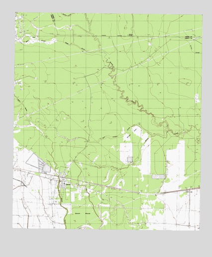
Devers, TX USGS Topographic Map
Click on map above to begin viewing in our Map Viewer.

This topographic map contains these locations and features:
Feature Name Type Latitude Longitude GNIS ID View Map
Batiste CreekStreamN30.0580°W94.5219°1330137View Map
Blau GullyValleyN30.0531°W94.6043°1330859View Map
Boyt Pre - Kindergarten SchoolSchoolN30.0277°W94.5905°2007869View Map
Bull Tongue CreekStreamN30.0544°W94.5330°1331613View Map
City of DeversCivilN30.0287°W94.5860°2410331View Map
Daisetta DivisionCivilN30.1124°W94.6061°1938667View Map
DeversPopulated PlaceN30.0274°W94.5916°1334286View Map
Devers City HallBuildingN30.0278°W94.5964°2753282View Map
Devers Elementary SchoolSchoolN30.0268°W94.5909°2007889View Map
Devers Post OfficePost OfficeN30.0271°W94.5922°2731952View Map
Devers Volunteer Fire DepartmentBuildingN30.0271°W94.5921°2334548View Map
Devers WoodsWoodsN30.0049°W94.5724°1373381View Map
FeliciaPopulated PlaceN30.0241°W94.5080°1378289View Map
Hogpen CrossingPopulated PlaceN30.0572°W94.5116°1378464View Map
Jerome SloughSwampN30.1127°W94.5463°1338716View Map
Keys CampLocaleN30.0944°W94.5424°1339071View Map
KHYS-FM (Port Arthur)TowerN30.0516°W94.5271°1388063View Map
KSHN-FM (Liberty)TowerN30.0516°W94.5271°1388022View Map
KSHN-FM (Liberty)TowerN30.1205°W94.6205°1388023View Map
KWIC-FM (Beaumont)TowerN30.0516°W94.5271°1387913View Map
KYKR-FM (Port Arthur)TowerN30.0516°W94.5271°1388062View Map
Meche ReservoirReservoirN30.0352°W94.5969°1861951View Map
Neds GullyValleyN30.1024°W94.5668°1342394View Map
Sahara CemeteryCemeteryN30.0002°W94.5416°1367119View Map
Stephen Meche DamDamN30.0352°W94.5969°1861950View Map
Stockpen PrairieFlatN30.1222°W94.5355°1347947View Map
Taylor CampLocaleN30.1169°W94.5521°1348285View Map
West End SloughStreamN30.1035°W94.5674°1349708View Map
Willow CoveBasinN30.0508°W94.5444°1350174View Map

Note: Coordinates in the location and feature list above are referenced to NAD83 datum.


Copyright (C) 2008-2025 Ryan Niemi / Sunset Dynamics ... All Rights Reserved