TopoQuest Logo
Do you find TopoQuest useful?
Help keep TopoQuest running and adding new maps/features by donating!
Bitcoin:  19c7KJd3qBynnjoSw5npx9KScwjBe4ifkT
Litecoin:  LXs6TkuXGGXo1vDsWCkWVdjQX94eUKd6ui
Home View Maps Find Maps Find Places Resources & Links


Sour Lake, Texas Topographic Map

USGS Map Title: Sour Lake, TX
USGS Map MRC: 30094B4
DRG (GeoTIFF) Download: o30094b4.tif


Neighboring USGS Topographic Map Quads:


  Saratoga, TX  
30094C5
 

  Kountze SW, TX  
30094C4
 

  Kountze South, TX  
30094C3
 

  Thorson Gully, TX  
30094B5
 

  Sour Lake, TX  
30094B4
 

  Bevil Oaks, TX  
30094B3
 

  Devers, TX  
30094A5
 

  Nome, TX  
30094A4
 

  China, TX  
30094A3


Map MRC Location:

N31°
W95°
N31°
W94°
H8 H7 H6 H5 H4 H3 H2 H1
G8 G7 G6 G5 G4 G3 G2 G1
F8 F7 F6 F5 F4 F3 F2 F1
E8 E7 E6 E5 E4 E3 E2 E1
D8 D7 D6 D5 D4 D3 D2 D1
C8 C7 C6 C5 C4 C3 C2 C1
B8 B7 B6 B5 B4 B3 B2 B1
A8 A7 A6 A5 A4 A3 A2 A1
N30°
W95°
N30°
W94°

Sour Lake, TX USGS 1:24K Topographic Map Preview:
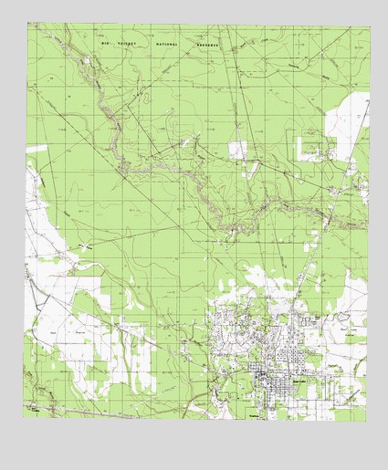
Sour Lake, TX USGS Topographic Map
Click on map above to begin viewing in our Map Viewer.

This topographic map contains these locations and features:
Feature Name Type Latitude Longitude GNIS ID View Map
Bushy LakeReservoirN30.1577°W94.3948°1331738View Map
City of Sour LakeCivilN30.1357°W94.4023°2411932View Map
Fourmile BurnoutAreaN30.2066°W94.4624°1336112View Map
Grassy LakeReservoirN30.1559°W94.3926°1336852View Map
Hardin County Constable's Office Precinct 4BuildingN30.1361°W94.4103°2751512View Map
HathawayPopulated PlaceN30.1277°W94.4819°1378427View Map
Jones PrairieFlatN30.1713°W94.4788°1338864View Map
Pelt PrairieFlatN30.1474°W94.4810°1343815View Map
Pignut GullyValleyN30.1403°W94.3794°1343992View Map
Rosedale CemeteryCemeteryN30.1316°W94.3982°1345572View Map
Saint Paul Baptist ChurchChurchN30.1452°W94.4202°2019399View Map
Sour LakePopulated PlaceN30.1402°W94.4110°1347394View Map
Sour Lake City HallBuildingN30.1402°W94.4122°2753602View Map
Sour Lake DivisionCivilN30.1574°W94.4074°1939207View Map
Sour Lake Dome Oil FieldOilfieldN30.1497°W94.4291°1347395View Map
Sour Lake Police DepartmentBuildingN30.1402°W94.4121°2375894View Map
Sour Lake Post OfficePost OfficeN30.1397°W94.4126°2731415View Map
Sour Lake Volunteer Fire Department / Hardin County Emergency Services District 5BuildingN30.1396°W94.4138°2334452View Map
The Sour LakesLakeN30.1594°W94.4077°1348462View Map
Yearling Tick BranchStreamN30.2044°W94.4435°1350661View Map

Note: Coordinates in the location and feature list above are referenced to NAD83 datum.


Copyright (C) 2008-2025 Ryan Niemi / Sunset Dynamics ... All Rights Reserved