TopoQuest Logo
Do you find TopoQuest useful?
Help keep TopoQuest running and adding new maps/features by donating!
Bitcoin:  19c7KJd3qBynnjoSw5npx9KScwjBe4ifkT
Litecoin:  LXs6TkuXGGXo1vDsWCkWVdjQX94eUKd6ui
Home View Maps Find Maps Find Places Resources & Links


Hardin, Texas Topographic Map

USGS Map Title: Hardin, TX
USGS Map MRC: 30094B6
DRG (GeoTIFF) Download: o30094b6.tif


Neighboring USGS Topographic Map Quads:


  Davis Hill, TX  
30094C7
 

  Arizona Creek, TX  
30094C6
 

  Saratoga, TX  
30094C5
 

  Capers Ridge, TX  
30094B7
 

  Hardin, TX  
30094B6
 

  Thorson Gully, TX  
30094B5
 

  Liberty, TX  
30094A7
 

  Daisetta, TX  
30094A6
 

  Devers, TX  
30094A5


Map MRC Location:

N31°
W95°
N31°
W94°
H8 H7 H6 H5 H4 H3 H2 H1
G8 G7 G6 G5 G4 G3 G2 G1
F8 F7 F6 F5 F4 F3 F2 F1
E8 E7 E6 E5 E4 E3 E2 E1
D8 D7 D6 D5 D4 D3 D2 D1
C8 C7 C6 C5 C4 C3 C2 C1
B8 B7 B6 B5 B4 B3 B2 B1
A8 A7 A6 A5 A4 A3 A2 A1
N30°
W95°
N30°
W94°

Hardin, TX USGS 1:24K Topographic Map Preview:
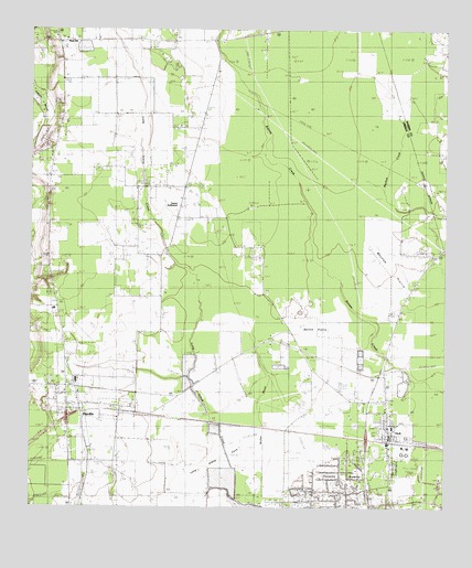
Hardin, TX USGS Topographic Map
Click on map above to begin viewing in our Map Viewer.

This topographic map contains these locations and features:
Feature Name Type Latitude Longitude GNIS ID View Map
Batiste PrairieFlatN30.1724°W94.6649°1330138View Map
Batiste WoodsWoodsN30.2141°W94.6663°1330139View Map
City of HardinCivilN30.1492°W94.7377°2410699View Map
Dowdel SettlementPopulated PlaceN30.1919°W94.6808°1377112View Map
HardinPopulated PlaceN30.1524°W94.7391°1337333View Map
Hardin City HallBuildingN30.1517°W94.7374°2753250View Map
Hardin Elementary SchoolSchoolN30.1768°W94.7427°2007896View Map
Hardin Post OfficePost OfficeN30.1605°W94.7387°2731780View Map
Hardin SchoolSchoolN30.1772°W94.7430°1337340View Map
Hardin Volunteer Fire DepartmentBuildingN30.1520°W94.7395°2334606View Map
Hawkins HillSummitN30.2033°W94.7441°1337474View Map
HullPopulated PlaceN30.1463°W94.6424°1338273View Map
Hull Census Designated PlaceCensusN30.1464°W94.6422°2586940View Map
Hull Oil and Gas FieldOilfieldN30.1255°W94.6669°1338274View Map
Hull Post OfficePost OfficeN30.1413°W94.6423°2731461View Map
Lake ForestReservoirN30.2219°W94.7473°1862931View Map
Lake Forest DamDamN30.2219°W94.7469°1862930View Map
Liberty County Constable's Office Precinct 3BuildingN30.1514°W94.7264°2751336View Map
Liberty County Fire Marshal's OfficeBuildingN30.2475°W94.7398°2334787View Map
Long Island CoveBasinN30.1341°W94.6916°1340477View Map
Long Island WoodsWoodsN30.1852°W94.6974°1340479View Map
Lovell Reservoir Number 1 LeveeDamN30.1469°W94.6935°1862779View Map
Mayhaw PrairieFlatN30.1888°W94.6408°1341121View Map
Moss HillPopulated PlaceN30.2474°W94.7416°1378703View Map
Moss Hill CemeteryCemeteryN30.2435°W94.7419°1341971View Map
Mount Calvary ChurchChurchN30.2472°W94.6933°1342015View Map
New HopePopulated PlaceN30.2127°W94.7419°1377111View Map
North Hill ChurchChurchN30.1910°W94.6288°1342754View Map
PedecoPopulated PlaceN30.1460°W94.6710°1384186View Map
Reservoir Number 1ReservoirN30.1456°W94.6941°1862780View Map
Tanner SettlementPopulated PlaceN30.2094°W94.7038°1379138View Map
Walker MarshStreamN30.1360°W94.6724°1349379View Map

Note: Coordinates in the location and feature list above are referenced to NAD83 datum.


Copyright (C) 2008-2025 Ryan Niemi / Sunset Dynamics ... All Rights Reserved