TopoQuest Logo
Do you find TopoQuest useful?
Help keep TopoQuest running and adding new maps/features by donating!
Bitcoin:  19c7KJd3qBynnjoSw5npx9KScwjBe4ifkT
Litecoin:  LXs6TkuXGGXo1vDsWCkWVdjQX94eUKd6ui
Home View Maps Find Maps Find Places Resources & Links


Devils Elbow, Missouri Topographic Map

USGS Map Title: Devils Elbow, MO
USGS Map MRC: 37092G1
DRG (GeoTIFF) Download: o37092g1.tif


Neighboring USGS Topographic Map Quads:


  Hancock, MO  
37092H2
 

  Dixon, MO  
37092H1
 

  Newburg, MO  
37091H8
 

  Waynesville, MO  
37092G2
 

  Devils Elbow, MO  
37092G1
 

  Kaintuck Hollow, MO  
37091G8
 

  Bloodland, MO  
37092F2
 

  Big Piney, MO  
37092F1
 

  Flat, MO  
37091F8


Map MRC Location:

N38°
W93°
N38°
W92°
H8 H7 H6 H5 H4 H3 H2 H1
G8 G7 G6 G5 G4 G3 G2 G1
F8 F7 F6 F5 F4 F3 F2 F1
E8 E7 E6 E5 E4 E3 E2 E1
D8 D7 D6 D5 D4 D3 D2 D1
C8 C7 C6 C5 C4 C3 C2 C1
B8 B7 B6 B5 B4 B3 B2 B1
A8 A7 A6 A5 A4 A3 A2 A1
N37°
W93°
N37°
W92°

Devils Elbow, MO USGS 1:24K Topographic Map Preview:
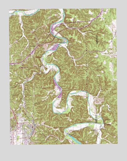
Devils Elbow, MO USGS Topographic Map
Click on map above to begin viewing in our Map Viewer.

This topographic map contains these locations and features:
Feature Name Type Latitude Longitude GNIS ID View Map
Anderson School (historical)SchoolN37.8437°W92.0902°753867View Map
Boulware CemeteryCemeteryN37.8137°W92.0183°2724159View Map
Calvary ChurchChurchN37.8589°W92.0713°749164View Map
Cedar Lodge (historical)LocaleN37.8450°W92.0552°753870View Map
Crawford Ousley CemeteryCemeteryN37.7911°W92.0227°2723640View Map
Decker (historical)LocaleN37.7989°W92.1091°759567View Map
Deckers PointCapeN37.7864°W92.0952°749600View Map
Deckers RidgeRidgeN37.7914°W92.0966°749601View Map
Devils ElbowPopulated PlaceN37.8459°W92.0638°749642View Map
Devils Elbow Post OfficePost OfficeN37.8464°W92.0614°2782583View Map
Dry CreekStreamN37.8259°W92.0841°749714View Map
Dry Creek CemeteryCemeteryN37.8164°W92.0899°749717View Map
Dry Creek Church (historical)ChurchN37.7637°W92.1168°753878View Map
Dry Creek School (historical)SchoolN37.7795°W92.1216°753877View Map
Fort Leonard Wood Fire and Emergency Services HeadquartersBuildingN37.7636°W92.1241°2620808View Map
Fort Leonard Wood State Wildlife Management AreaParkN37.8212°W92.1166°753442View Map
Fort Wood Lookout TowerTowerN37.8237°W92.1166°755183View Map
General Leonard Wood Army Community HospitalHospitalN37.7660°W92.1147°2655084View Map
Grahams Resort (historical)LocaleN37.8445°W92.0629°753871View Map
Hale CemeteryCemeteryN37.7606°W92.0529°750191View Map
Hiawatha Lodge (historical)LocaleN37.8464°W92.0588°753869View Map
HookerPopulated PlaceN37.8600°W92.0607°750379View Map
Hooker HollowValleyN37.8555°W92.0447°750380View Map
Hooker SchoolSchoolN37.8578°W92.0516°750381View Map
Hunt SidingLocaleN37.8523°W92.0010°750421View Map
Lee SidingLocaleN37.8009°W92.1088°750678View Map
Lost HillSummitN37.8198°W92.0838°750868View Map
Low Gap School (historical)LocaleN37.7875°W92.0516°753373View Map
Mayfield CemeteryCemeteryN37.7853°W92.0665°754073View Map
Maze School (historical)SchoolN37.8048°W92.0660°753875View Map
Meadow Brook LodgeLocaleN37.8248°W92.0738°753873View Map
MoabLocaleN37.7914°W92.0660°751135View Map
Morgan HeightsPopulated PlaceN37.8412°W92.0946°751157View Map
Mossy Resort (historical)Populated PlaceN37.8689°W92.1227°753864View Map
Mossy SpringSpringN37.8672°W92.1245°751166View Map
Munger Resort (historical)Populated PlaceN37.8517°W92.0760°753868View Map
Ormsby PlaceLocaleN37.7603°W92.0560°753876View Map
Ousley CemeteryCemeteryN37.8729°W92.0188°2724134View Map
Ousley SpringSpringN37.7965°W92.0327°751459View Map
Possum LodgeLocaleN37.8606°W92.0771°753865View Map
Rigsby Cottages (historical)BuildingN37.8375°W92.0777°753872View Map
Riverside (historical)Populated PlaceN37.8744°W92.1106°2650318View Map
Rockwell CemeteryCemeteryN37.7603°W92.1082°751934View Map
Round Pond HollowValleyN37.8062°W92.1116°751974View Map
Shanghai SpringSpringN37.8292°W92.0891°752096View Map
Shultz FordLocaleN37.7962°W92.0743°752145View Map
Smoky HollowValleyN37.7772°W92.0210°752228View Map
Spaulding CemeteryCemeteryN37.8567°W92.0960°752282View Map
Spring CreekPopulated PlaceN37.7625°W92.0240°752298View Map
Spring CreekStreamN37.7681°W92.0188°752305View Map
Spring Creek BluffCliffN37.7691°W92.0153°752308View Map
Spring Creek CemeteryCemeteryN37.7625°W92.0260°752309View Map
Spring Creek SchoolLocaleN37.7653°W92.0165°753372View Map
Stewart Camp (historical)LocaleN37.8675°W92.0591°753866View Map
Strawstack HollowValleyN37.7933°W92.0281°752395View Map
Thompson CemeteryCemeteryN37.7909°W92.0527°754072View Map
Ware HollowValleyN37.8514°W92.1096°752759View Map
Waynesville Rural Fire Protection District Station 3BuildingN37.8550°W92.0974°2620428View Map
Weeks HollowValleyN37.8703°W92.1143°752794View Map
Wern SidingLocaleN37.8409°W92.0774°752804View Map

Note: Coordinates in the location and feature list above are referenced to NAD83 datum.


Copyright (C) 2008-2024 Ryan Niemi / Sunset Dynamics ... All Rights Reserved