TopoQuest Logo
Do you find TopoQuest useful?
Help keep TopoQuest running and adding new maps/features by donating!
Bitcoin:  19c7KJd3qBynnjoSw5npx9KScwjBe4ifkT
Litecoin:  LXs6TkuXGGXo1vDsWCkWVdjQX94eUKd6ui
Home View Maps Find Maps Find Places Resources & Links


Newburg, Missouri Topographic Map

USGS Map Title: Newburg, MO
USGS Map MRC: 37091H8
DRG (GeoTIFF) Download: o37091h8.tif


Neighboring USGS Topographic Map Quads:


  Big Bend, MO  
38092A1
 

  Nagogami Lodge, MO  
38091A8
 

  Vichy, MO  
38091A7
 

  Dixon, MO  
37092H1
 

  Newburg, MO  
37091H8
 

  Rolla, MO  
37091H7
 

  Devils Elbow, MO  
37092G1
 

  Kaintuck Hollow, MO  
37091G8
 

  Yancy Mills, MO  
37091G7


Map MRC Location:

N38°
W92°
N38°
W91°
H8 H7 H6 H5 H4 H3 H2 H1
G8 G7 G6 G5 G4 G3 G2 G1
F8 F7 F6 F5 F4 F3 F2 F1
E8 E7 E6 E5 E4 E3 E2 E1
D8 D7 D6 D5 D4 D3 D2 D1
C8 C7 C6 C5 C4 C3 C2 C1
B8 B7 B6 B5 B4 B3 B2 B1
A8 A7 A6 A5 A4 A3 A2 A1
N37°
W92°
N37°
W91°

Newburg, MO USGS 1:24K Topographic Map Preview:
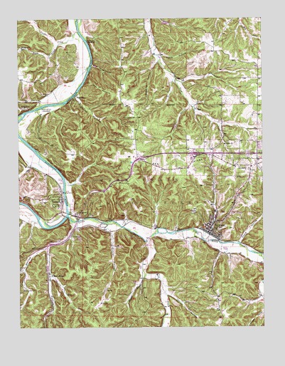
Newburg, MO USGS Topographic Map
Click on map above to begin viewing in our Map Viewer.

This topographic map contains these locations and features:
Feature Name Type Latitude Longitude GNIS ID View Map
Affolter LakeReservoirN37.9862°W91.9337°765133View Map
Affolter Lake DamDamN37.9867°W91.9335°765132View Map
Alhambra Grotto Recreation Park (historical)ParkN37.9217°W91.9238°753801View Map
ArlingtonPopulated PlaceN37.9203°W91.9710°748611View Map
Arlington LakeReservoirN37.9250°W91.9752°754151View Map
Arlington School (historical)SchoolN37.9125°W91.9768°753163View Map
Baptist ChurchChurchN37.9176°W91.9004°2562764View Map
Baptist Church of NewburgChurchN37.9169°W91.9004°2562765View Map
Boulware FordLocaleN37.9914°W91.9649°748972View Map
Brick House CemeteryCemeteryN37.9864°W91.9650°2723631View Map
Brick House HollowValleyN37.9809°W91.9618°749017View Map
Bryant CemeteryCemeteryN37.9420°W91.9959°2724087View Map
Cave Spring Creek CemeteryCemeteryN37.9801°W91.9252°2724069View Map
City of DoolittleCivilN37.9426°W91.8893°2394547View Map
City of NewburgCivilN37.9168°W91.9001°2395222View Map
Devils BackboneRidgeN37.9714°W91.9571°749634View Map
Dexter Smith CemeteryCemeteryN37.9690°W91.8858°2724078View Map
DoolittlePopulated PlaceN37.9403°W91.8810°749680View Map
Doolittle Rural Fire Protection Association Station 1BuildingN37.9399°W91.8842°2621663View Map
Doolittle Rural Fire Protection Association Station 2BuildingN37.9242°W91.9783°2620800View Map
Duncan CemeteryCemeteryN37.9369°W91.9862°2724086View Map
Duncan CreekStreamN37.9950°W91.9688°749747View Map
Fable HollowValleyN37.9850°W91.9257°749879View Map
First Baptist ChurchChurchN37.9233°W91.9789°2562745View Map
Glover HollowValleyN37.9134°W91.9527°750054View Map
Gottschall SchoolSchoolN37.9514°W91.9504°753161View Map
Harrison Number 2 CemeteryCemeteryN37.9352°W91.9696°2724085View Map
Harrison-Pillman CemeteryCemeteryN37.9125°W91.9704°751589View Map
Hickory Point School (historical)SchoolN37.8862°W91.8852°753164View Map
JeromePopulated PlaceN37.9262°W91.9777°750506View Map
Kitchell CemeteryCemeteryN37.8850°W91.9588°750627View Map
Knotwell School (historical)SchoolN37.9078°W91.9357°753800View Map
Lead ProspectMineN37.9098°W91.8821°753803View Map
Little Piney CreekStreamN37.9202°W91.9752°750792View Map
Luckey Chapel CemeteryCemeteryN37.9385°W91.8766°2723872View Map
Martin Lake DamDamN37.9484°W91.8768°764161View Map
Martin ReservoirReservoirN37.9478°W91.8765°764162View Map
Merrill HollowValleyN37.8881°W91.9246°751022View Map
Mill CreekStreamN37.9110°W91.9344°751073View Map
Mount Olive CemeteryCemeteryN37.9496°W91.8924°2724023View Map
Mount Olive ChurchChurchN37.9500°W91.8929°751186View Map
Mungy BranchStreamN37.9900°W91.9785°751234View Map
Mungy SchoolSchoolN37.9887°W91.9985°751235View Map
New Home ChurchChurchN37.9600°W91.9399°751291View Map
NewburgPopulated PlaceN37.9142°W91.9027°751306View Map
Newburg CemeteryCemeteryN37.9217°W91.9107°751307View Map
Newburg Fire DepartmentBuildingN37.9135°W91.9014°2621662View Map
Newburg HeightsLocaleN37.9467°W91.9018°753802View Map
Newburg Police DeptBuildingN37.9145°W91.9031°2752578View Map
Newburg Post OfficePost OfficeN37.9139°W91.9042°2782692View Map
Ozark Iron Works (historical)LocaleN37.9164°W91.9310°753799View Map
Perkins SchoolSchoolN37.9431°W91.8904°753162View Map
Poole HollowValleyN37.9092°W91.8877°751708View Map
Ramsey CemeteryCemeteryN37.9673°W91.9896°751804View Map
Roderick HollowValleyN37.9825°W91.9279°751944View Map
Roluf SpringSpringN37.8962°W91.9831°751955View Map
Sisco CemeteryCemeteryN37.9788°W91.8993°2724076View Map
Smith Farm CemeteryCemeteryN37.9754°W91.9143°2724074View Map
Smith HollowValleyN37.9067°W91.9857°752220View Map
Stony DellLocaleN37.9120°W91.9768°753101View Map
Stony Dell Swimming Pool (historical)ReservoirN37.9109°W91.9760°753798View Map
SugartreePopulated PlaceN37.9678°W91.9707°752422View Map
Sugartree HollowValleyN37.9698°W91.9693°752424View Map
Table RockPopulated PlaceN37.9637°W91.9966°752476View Map
Tater HollowValleyN37.9153°W91.9721°752496View Map
The Apostolic Faith ChurchChurchN37.9454°W91.9858°2571466View Map
Township of ArlingtonCivilN37.9320°W91.9485°767176View Map
Wagner BranchStreamN37.8967°W91.9352°752725View Map
Westcott (historical)Populated PlaceN37.9720°W91.8985°740043View Map
Whitehouse Ferry (historical)CrossingN37.9620°W91.9963°753797View Map
Whitehouse FordLocaleN37.9648°W91.9849°752865View Map
Whitehouse Ford Boat AccessLocaleN37.9634°W91.9904°754423View Map
Williams CemeteryCemeteryN37.9109°W91.9136°2724089View Map
Wynn SchoolSchoolN37.9798°W91.9229°753160View Map
Wynn-Richards CemeteryCemeteryN37.9979°W91.9376°2724065View Map
Yates HollowValleyN37.9650°W91.9121°752997View Map

Note: Coordinates in the location and feature list above are referenced to NAD83 datum.


Copyright (C) 2008-2024 Ryan Niemi / Sunset Dynamics ... All Rights Reserved