TopoQuest Logo
Do you find TopoQuest useful?
Help keep TopoQuest running and adding new maps/features by donating!
Bitcoin:  19c7KJd3qBynnjoSw5npx9KScwjBe4ifkT
Litecoin:  LXs6TkuXGGXo1vDsWCkWVdjQX94eUKd6ui
Home View Maps Find Maps Find Places Resources & Links


Hancock, Missouri Topographic Map

USGS Map Title: Hancock, MO
USGS Map MRC: 37092H2
DRG (GeoTIFF) Download: o37092h2.tif


Neighboring USGS Topographic Map Quads:


  Iberia, MO  
38092A3
 

  Brays, MO  
38092A2
 

  Big Bend, MO  
38092A1
 

  Crocker, MO  
37092H3
 

  Hancock, MO  
37092H2
 

  Dixon, MO  
37092H1
 

  Ozark Springs, MO  
37092G3
 

  Waynesville, MO  
37092G2
 

  Devils Elbow, MO  
37092G1


Map MRC Location:

N38°
W93°
N38°
W92°
H8 H7 H6 H5 H4 H3 H2 H1
G8 G7 G6 G5 G4 G3 G2 G1
F8 F7 F6 F5 F4 F3 F2 F1
E8 E7 E6 E5 E4 E3 E2 E1
D8 D7 D6 D5 D4 D3 D2 D1
C8 C7 C6 C5 C4 C3 C2 C1
B8 B7 B6 B5 B4 B3 B2 B1
A8 A7 A6 A5 A4 A3 A2 A1
N37°
W93°
N37°
W92°

Hancock, MO USGS 1:24K Topographic Map Preview:
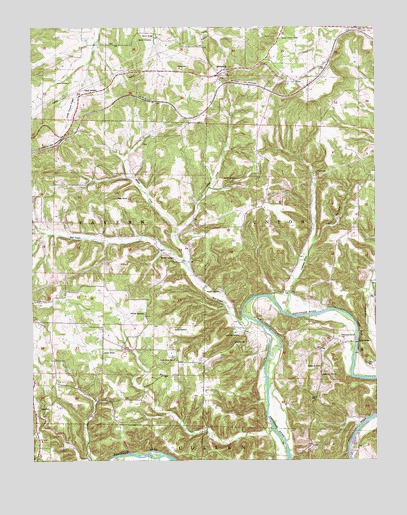
Hancock, MO USGS Topographic Map
Click on map above to begin viewing in our Map Viewer.

This topographic map contains these locations and features:
Feature Name Type Latitude Longitude GNIS ID View Map
Antioch CemeteryCemeteryN37.9167°W92.2093°713311View Map
Bates SchoolSchoolN37.9506°W92.2191°713730View Map
Bell CreekStreamN37.9156°W92.1716°729429View Map
Brake CemeteryCemeteryN37.9123°W92.1979°714628View Map
Brown SchoolSchoolN37.9978°W92.2052°714783View Map
Clemens CreekStreamN37.9170°W92.1560°715963View Map
Cowan SchoolSchoolN37.9059°W92.2243°716414View Map
Decker CemeteryCemeteryN37.9967°W92.2060°716781View Map
Dixon HollowValleyN37.9378°W92.1471°716926View Map
Dixon Lookout TowerTowerN37.9970°W92.1585°755166View Map
Gasconade Church CemeteryCemeteryN37.9106°W92.1382°718367View Map
Hamilton SchoolLocaleN37.9459°W92.1641°742467View Map
HancockPopulated PlaceN37.9864°W92.1818°729507View Map
HelmPopulated PlaceN37.9842°W92.1543°719352View Map
Joiner CemeteryCemeteryN37.9845°W92.2357°720389View Map
Jury SidingLocaleN37.9795°W92.2099°740400View Map
Lipscomb CemeteryCemeteryN37.9114°W92.1749°721143View Map
Middle CreekStreamN37.9328°W92.1954°722269View Map
Mitchell CemeteryCemeteryN37.9328°W92.1982°722486View Map
Mitchell Church (historical)ChurchN37.9331°W92.1988°744630View Map
Mitchell SpringSpringN37.9359°W92.2045°738963View Map
Needmore MissionChurchN37.8992°W92.1449°723145View Map
Needmore SchoolSchoolN37.9014°W92.1457°723146View Map
Rhodes SpurLocaleN37.9987°W92.1302°740401View Map
Riddle BridgeBridgeN37.9089°W92.1321°755377View Map
Sewell CemeteryCemeteryN37.9561°W92.1802°726218View Map
Sewell CreekStreamN37.9400°W92.1979°726220View Map
Shady RestLocaleN37.9187°W92.1385°744634View Map
Sweet Home ChurchChurchN37.9039°W92.1977°727378View Map
Sweet Home School (historical)SchoolN37.8920°W92.1874°744631View Map
Teeple CemeteryCemeteryN37.9814°W92.2304°727518View Map
Underwood PlaceLocaleN37.9089°W92.1388°744632View Map
Vaughn CemeteryCemeteryN37.9231°W92.1816°728154View Map
W E Wilton DamDamN37.9534°W92.1752°763747View Map
W E Wilton LakeReservoirN37.9538°W92.1748°763748View Map
Wheeler LakeReservoirN37.9120°W92.1766°738969View Map
Wheeler Resort (historical)LocaleN37.9114°W92.1735°738968View Map
Wheeler SpringSpringN37.9115°W92.1776°738970View Map
Wheelers MillPopulated PlaceN37.9084°W92.1760°741354View Map
Yellow BluffCliffN37.9125°W92.1313°729198View Map
Yellow Bluff Cottages (historical)BuildingN37.9100°W92.1332°744633View Map

Note: Coordinates in the location and feature list above are referenced to NAD83 datum.


Copyright (C) 2008-2025 Ryan Niemi / Sunset Dynamics ... All Rights Reserved