TopoQuest Logo
Do you find TopoQuest useful?
Help keep TopoQuest running and adding new maps/features by donating!
Bitcoin:  19c7KJd3qBynnjoSw5npx9KScwjBe4ifkT
Litecoin:  LXs6TkuXGGXo1vDsWCkWVdjQX94eUKd6ui
Home View Maps Find Maps Find Places Resources & Links


Dimple, Texas Topographic Map

USGS Map Title: Dimple, TX
USGS Map MRC: 33095F1
DRG (GeoTIFF) Download: o33095f1.tif


Neighboring USGS Topographic Map Quads:


  Manchester, TX  
33095G2
 

  Negley, TX  
33095G1
 

  Acworth, TX  
33094G8
 

  Bagwell, TX  
33095F2
 

  Dimple, TX  
33095F1
 

  White Rock, TX  
33094F8
 

  Line Branch, TX  
33095E2
 

  Clarksville, TX  
33095E1
 

  Annona, TX  
33094E8


Map MRC Location:

N34°
W96°
N34°
W95°
H8 H7 H6 H5 H4 H3 H2 H1
G8 G7 G6 G5 G4 G3 G2 G1
F8 F7 F6 F5 F4 F3 F2 F1
E8 E7 E6 E5 E4 E3 E2 E1
D8 D7 D6 D5 D4 D3 D2 D1
C8 C7 C6 C5 C4 C3 C2 C1
B8 B7 B6 B5 B4 B3 B2 B1
A8 A7 A6 A5 A4 A3 A2 A1
N33°
W96°
N33°
W95°

Dimple, TX USGS 1:24K Topographic Map Preview:
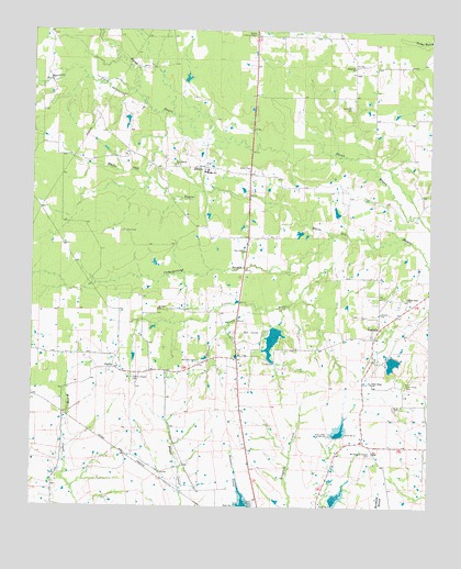
Dimple, TX USGS Topographic Map
Click on map above to begin viewing in our Map Viewer.

This topographic map contains these locations and features:
Feature Name Type Latitude Longitude GNIS ID View Map
Arrowhead Ranch LakeReservoirN33.6631°W95.0118°1860366View Map
Arrowhead Ranch Lake DamDamN33.6634°W95.0102°1860365View Map
Blanton CreekStreamN33.7337°W95.0933°1352409View Map
Campground BayouStreamN33.6968°W95.0313°1353703View Map
Carroll CreekStreamN33.6768°W95.0511°1353878View Map
CherryLocaleN33.6615°W95.0986°1354348View Map
Dam Number 2DamN33.6251°W95.0583°1355583View Map
Dam Number 3DamN33.6440°W95.0280°1355594View Map
Dam Number 4DamN33.6265°W95.0308°1355597View Map
DimplePopulated PlaceN33.7143°W95.0716°1356031View Map
Free Hope CemeteryCemeteryN33.6576°W95.0080°1357705View Map
Free Hope ChurchChurchN33.6576°W95.0183°1357707View Map
Hopewell CemeteryCemeteryN33.7301°W95.0247°1359546View Map
Hopewell ChurchChurchN33.7404°W95.0244°1359554View Map
Little BayouStreamN33.6957°W95.0249°1361271View Map
Mount Zion ChurchChurchN33.6768°W95.0855°1363368View Map
Negley Lookout TowerTowerN33.7493°W95.0558°1384627View Map
New Haven ChurchChurchN33.7146°W95.0808°1363715View Map
North LakeReservoirN33.6688°W95.0495°1364083View Map
North Lake DamDamN33.6718°W95.0469°1860367View Map
Pine Grove ChurchChurchN33.6921°W95.0583°1365282View Map
Shiloh CemeteryCemeteryN33.6518°W95.0086°1368157View Map
Slate Rock ChurchChurchN33.6801°W95.0072°1368401View Map
Soil Conservation Service Site 1 ReservoirReservoirN33.6266°W95.0428°1860340View Map
Soil Conservation Service Site 2 DamDamN33.6251°W95.0569°1860341View Map
Soil Conservation Service Site 2 ReservoirReservoirN33.6257°W95.0583°1860342View Map
Soil Conservation Service Site 3 DamDamN33.6435°W95.0287°1860369View Map
Soil Conservation Service Site 3 ReservoirReservoirN33.6443°W95.0283°1860370View Map
Soil Conservation Service Site 4 DamDamN33.6259°W95.0307°1860371View Map
Soil Conservation Service Site 4 ReservoirReservoirN33.6269°W95.0299°1860372View Map
Stone Chapel CemeteryCemeteryN33.6590°W95.0930°1369234View Map
Texas Forest Service Clarksville OfficeBuildingN33.6759°W95.0608°2655575View Map
VandaliaPopulated PlaceN33.6718°W95.0158°1380709View Map
Whitemans Chapel CemeteryCemeteryN33.6390°W95.0177°1371447View Map
Williams CemeteryCemeteryN33.6632°W95.0727°1371566View Map

Note: Coordinates in the location and feature list above are referenced to NAD83 datum.


Copyright (C) 2008-2025 Ryan Niemi / Sunset Dynamics ... All Rights Reserved