TopoQuest Logo
Do you find TopoQuest useful?
Help keep TopoQuest running and adding new maps/features by donating!
Bitcoin:  19c7KJd3qBynnjoSw5npx9KScwjBe4ifkT
Litecoin:  LXs6TkuXGGXo1vDsWCkWVdjQX94eUKd6ui
Home View Maps Find Maps Find Places Resources & Links


Dixon West, Illinois Topographic Map

USGS Map Title: Dixon West, IL
USGS Map MRC: 41089G5
DRG (GeoTIFF) Download: o41089g5.tif


Neighboring USGS Topographic Map Quads:


  Hazelhurst, IL  
41089H6
 

  Polo, IL  
41089H5
 

  Grand Detour, IL  
41089H4
 

  Sterling, IL  
41089G6
 

  Dixon West, IL  
41089G5
 

  Dixon East, IL  
41089G4
 

  Hahnaman, IL  
41089F6
 

  Harmon, IL  
41089F5
 

  Walton, IL  
41089F4


Map MRC Location:

N42°
W90°
N42°
W89°
H8 H7 H6 H5 H4 H3 H2 H1
G8 G7 G6 G5 G4 G3 G2 G1
F8 F7 F6 F5 F4 F3 F2 F1
E8 E7 E6 E5 E4 E3 E2 E1
D8 D7 D6 D5 D4 D3 D2 D1
C8 C7 C6 C5 C4 C3 C2 C1
B8 B7 B6 B5 B4 B3 B2 B1
A8 A7 A6 A5 A4 A3 A2 A1
N41°
W90°
N41°
W89°

Dixon West, IL USGS 1:24K Topographic Map Preview:
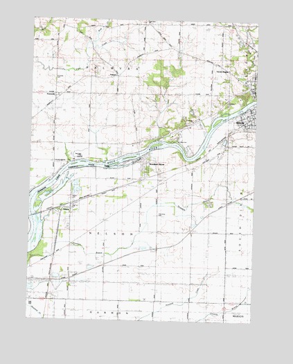
Dixon West, IL USGS Topographic Map
Click on map above to begin viewing in our Map Viewer.

This topographic map contains these locations and features:
Feature Name Type Latitude Longitude GNIS ID View Map
Advance Emergency Medical Services of DixonBuildingN41.8469°W89.5038°2674016View Map
Collins Airstrip (historical)AirportN41.8156°W89.6076°1816524View Map
Community ChurchChurchN41.8331°W89.5354°1706153View Map
Cook School (historical)SchoolN41.8070°W89.5532°406506View Map
Gap Grove (historical)WoodsN41.8414°W89.5598°1816547View Map
Gearhart-Hollow HeliportAirportN41.8648°W89.5029°427223View Map
Gerdes QuarryMineN41.8267°W89.5140°1985558View Map
Hennepin Canal Parkway State ParkParkN41.7917°W89.6229°1718950View Map
Hillhouse School (historical)SchoolN41.8225°W89.5159°410281View Map
Kimbal School (historical)SchoolN41.7528°W89.6018°411476View Map
Kings School (historical)SchoolN41.7586°W89.5526°411513View Map
Lincoln HeightsPopulated PlaceN41.8559°W89.5204°1718936View Map
Memorial PoolParkN41.8356°W89.5068°1816568View Map
Midway Drive-InLocaleN41.8383°W89.6133°2634352View Map
NelsonPopulated PlaceN41.7964°W89.6018°414346View Map
Nelson CemeteryCemeteryN41.8010°W89.6015°414351View Map
Nelson Elementary SchoolSchoolN41.7970°W89.5998°1816573View Map
Northside ChurchChurchN41.8411°W89.5159°1706155View Map
Oak Forest School (historical)SchoolN41.8250°W89.5634°414762View Map
PalmyraPopulated PlaceN41.8517°W89.5779°415322View Map
Pine Grove CemeteryCemeteryN41.7942°W89.5530°421637View Map
Plum Hollow Golf Course (historical)LocaleN41.8625°W89.5070°425341View Map
PrairievillePopulated PlaceN41.8414°W89.6121°416184View Map
Prairieville CemeteryCemeteryN41.8509°W89.6129°416185View Map
Propheter QuarryMineN41.8548°W89.5915°1985560View Map
Reid CreekStreamN41.8648°W89.5923°416513View Map
Reynolds FieldParkN41.8367°W89.5051°1816578View Map
Rock Ridge CemeteryCemeteryN41.8247°W89.5448°416823View Map
Sauk Valley Community CollegeSchoolN41.8175°W89.5979°1706154View Map
Sugar Grove CemeteryCemeteryN41.8736°W89.5598°1816592View Map
Sugar Grove ChurchChurchN41.8734°W89.5609°1816593View Map
Township of NelsonCivilN41.7880°W89.5674°429424View Map
Township of PalmyraCivilN41.8579°W89.5762°429522View Map
Vaile ParkParkN41.8361°W89.5068°1816597View Map
Village of NelsonCivilN41.7961°W89.6035°2399443View Map
Walker School (historical)SchoolN41.7875°W89.5334°420415View Map
Wildcat School (historical)SchoolN41.8667°W89.5190°421156View Map
Wolverine School (historical)SchoolN41.8373°W89.5257°421406View Map
Woodland ShoresPopulated PlaceN41.8148°W89.5615°1718937View Map

Note: Coordinates in the location and feature list above are referenced to NAD83 datum.


Copyright (C) 2008-2024 Ryan Niemi / Sunset Dynamics ... All Rights Reserved