TopoQuest Logo
Do you find TopoQuest useful?
Help keep TopoQuest running and adding new maps/features by donating!
Bitcoin:  19c7KJd3qBynnjoSw5npx9KScwjBe4ifkT
Litecoin:  LXs6TkuXGGXo1vDsWCkWVdjQX94eUKd6ui
Home View Maps Find Maps Find Places Resources & Links


Dobbersville, North Carolina Topographic Map

USGS Map Title: Dobbersville, NC
USGS Map MRC: 35078B2
DRG (GeoTIFF) Download: o35078b2.tif


Neighboring USGS Topographic Map Quads:


  Newton Grove North, NC  
35078C3
 

  Grantham, NC  
35078C2
 

  Southwest Goldsboro, NC  
35078C1
 

  Newton Grove South, NC  
35078B3
 

  Dobbersville, NC  
35078B2
 

  Mount Olive, NC  
35078B1
 

  Clinton North, NC  
35078A3
 

  Faison, NC  
35078A2
 

  Warsaw North, NC  
35078A1


Map MRC Location:

N36°
W79°
N36°
W78°
H8 H7 H6 H5 H4 H3 H2 H1
G8 G7 G6 G5 G4 G3 G2 G1
F8 F7 F6 F5 F4 F3 F2 F1
E8 E7 E6 E5 E4 E3 E2 E1
D8 D7 D6 D5 D4 D3 D2 D1
C8 C7 C6 C5 C4 C3 C2 C1
B8 B7 B6 B5 B4 B3 B2 B1
A8 A7 A6 A5 A4 A3 A2 A1
N35°
W79°
N35°
W78°

Dobbersville, NC USGS 1:24K Topographic Map Preview:
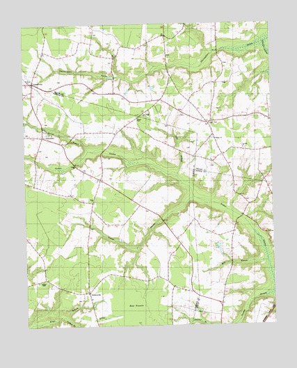
Dobbersville, NC USGS Topographic Map
Click on map above to begin viewing in our Map Viewer.

This topographic map contains these locations and features:
Feature Name Type Latitude Longitude GNIS ID View Map
Bear PocosinFlatN35.1321°W78.1953°1025118View Map
Bethlehem ChurchChurchN35.1288°W78.2139°981205View Map
Brownings ChurchChurchN35.2266°W78.2469°982025View Map
Clifton BranchStreamN35.1288°W78.2311°983284View Map
Concord Church (historical)ChurchN35.1449°W78.2394°1952613View Map
DobbersvillePopulated PlaceN35.2263°W78.2447°984233View Map
GiddensvillePopulated PlaceN35.1391°W78.2183°985676View Map
Goshen ChurchChurchN35.1913°W78.2242°985846View Map
Hines School (historical)SchoolN35.1571°W78.1736°1952617View Map
Kings ChurchChurchN35.1777°W78.2153°987992View Map
Kings School (historical)SchoolN35.1774°W78.2153°1952618View Map
Long BranchStreamN35.1868°W78.1728°988892View Map
Mill BranchStreamN35.1516°W78.1278°989871View Map
Piney Grove Volunteer Fire Department of SampsonBuildingN35.1389°W78.2196°2639415View Map
Railer BranchStreamN35.1977°W78.2175°992990View Map
Saint Lukes ChurchChurchN35.1985°W78.1392°993989View Map
Saints Delight ChurchChurchN35.2127°W78.1900°994149View Map
Skeeter PointPopulated PlaceN35.1857°W78.2117°1952629View Map
Smith ChapelChurchN35.2088°W78.1555°994956View Map
Smith Chapel Volunteer Fire DepartmentBuildingN35.2067°W78.1548°2639252View Map
Suttons Store (historical)LocaleN35.1952°W78.2278°1952624View Map
SuttontownPopulated PlaceN35.2035°W78.2406°995733View Map
Suttontown Rescue SquadBuildingN35.2033°W78.2409°2720529View Map
Thunder SwampStreamN35.2424°W78.1267°996089View Map
Township of Piney GroveCivilN35.1593°W78.2344°1027180View Map
Wesley ChurchChurchN35.2021°W78.1528°996971View Map
Youngs SwampStreamN35.1782°W78.1642°997741View Map

Note: Coordinates in the location and feature list above are referenced to NAD83 datum.


Copyright (C) 2008-2025 Ryan Niemi / Sunset Dynamics ... All Rights Reserved