TopoQuest Logo
Do you find TopoQuest useful?
Help keep TopoQuest running and adding new maps/features by donating!
Bitcoin:  19c7KJd3qBynnjoSw5npx9KScwjBe4ifkT
Litecoin:  LXs6TkuXGGXo1vDsWCkWVdjQX94eUKd6ui
Home View Maps Find Maps Find Places Resources & Links


Doe Hill, Virginia Topographic Map

USGS Map Title: Doe Hill, VA
USGS Map MRC: 38079D4
DRG (GeoTIFF) Download: o38079d4.tif


Neighboring USGS Topographic Map Quads:


  Snowy Mountain, WV  
38079E5
 

  Moatstown, WV  
38079E4
 

  Sugar Grove, WV  
38079E3
 

  Monterey, VA  
38079D5
 

  Doe Hill, VA  
38079D4
 

  Palo Alto, VA  
38079D3
 

  Monterey SE, VA  
38079C5
 

  McDowell, VA  
38079C4
 

  West Augusta, VA  
38079C3


Map MRC Location:

N39°
W80°
N39°
W79°
H8 H7 H6 H5 H4 H3 H2 H1
G8 G7 G6 G5 G4 G3 G2 G1
F8 F7 F6 F5 F4 F3 F2 F1
E8 E7 E6 E5 E4 E3 E2 E1
D8 D7 D6 D5 D4 D3 D2 D1
C8 C7 C6 C5 C4 C3 C2 C1
B8 B7 B6 B5 B4 B3 B2 B1
A8 A7 A6 A5 A4 A3 A2 A1
N38°
W80°
N38°
W79°

Doe Hill, VA USGS 1:24K Topographic Map Preview:
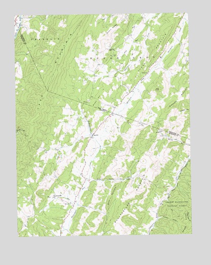
Doe Hill, VA USGS Topographic Map
Click on map above to begin viewing in our Map Viewer.

This topographic map contains these locations and features:
Feature Name Type Latitude Longitude GNIS ID View Map
Botkin HollowValleyN38.4065°W79.4468°1481941View Map
Brushy HillSummitN38.4521°W79.4409°1492651View Map
Buck MountainSummitN38.3943°W79.4334°1492657View Map
Bullpasture MountainSummitN38.3990°W79.4120°1492673View Map
Carroll DraftStreamN38.3840°W79.3998°1482336View Map
Company 7 South River Fire DepartmentBuildingN38.4753°W79.4667°2086004View Map
Crummett SpringSpringN38.4757°W79.3775°1677621View Map
Doe HillPopulated PlaceN38.4321°W79.4445°1492871View Map
Doe Hill Post OfficePost OfficeN38.4320°W79.4446°2766355View Map
Doe Hill School (historical)SchoolN38.4332°W79.4462°1673767View Map
Frye KnobSummitN38.4571°W79.3964°1551192View Map
Grottoes Volunteer Fire Company 20BuildingN38.4364°W79.3756°2086017View Map
Hiner SpringsSpringN38.4562°W79.4178°1677622View Map
Jack MountainRidgeN38.4793°W79.4667°1551553View Map
Jones TrailTrailN38.3862°W79.3873°1484508View Map
Judy SpringSpringN38.4829°W79.3812°1677623View Map
Lynn Rock ChurchChurchN38.4073°W79.4200°1485142View Map
McKendree ChurchChurchN38.3940°W79.4617°1485308View Map
Mill RunStreamN38.3926°W79.4575°1485455View Map
Plum RunStreamN38.4868°W79.4042°1552513View Map
Sanders Farm SpringSpringN38.4690°W79.4470°1677620View Map
Shaws RidgeRidgeN38.3810°W79.3764°1487164View Map
Simmons MountainSummitN38.4479°W79.3870°1552893View Map
Sirons MillPopulated PlaceN38.3976°W79.4731°1493602View Map
Thorn MountainRidgeN38.4912°W79.3887°1553218View Map
Totten CemeteryCemeteryN38.4768°W79.4295°1553252View Map
Totten ChapelChurchN38.4801°W79.4300°1553253View Map
Whiteman RunStreamN38.4179°W79.3764°1488326View Map

Note: Coordinates in the location and feature list above are referenced to NAD83 datum.


Copyright (C) 2008-2024 Ryan Niemi / Sunset Dynamics ... All Rights Reserved