TopoQuest Logo
Do you find TopoQuest useful?
Help keep TopoQuest running and adding new maps/features by donating!
Bitcoin:  19c7KJd3qBynnjoSw5npx9KScwjBe4ifkT
Litecoin:  LXs6TkuXGGXo1vDsWCkWVdjQX94eUKd6ui
Home View Maps Find Maps Find Places Resources & Links


Domino, Texas Topographic Map

USGS Map Title: Domino, TX
USGS Map MRC: 33094C1
DRG (GeoTIFF) Download: o33094c1.tif


Neighboring USGS Topographic Map Quads:


  Leary, TX  
33094D2
 

  Texarkana, TX  
33094D1
 

  Mandeville, AR  
33093D8
 

  Wright Patman Lake, TX  
33094C2
 

  Domino, TX  
33094C1
 

  Fouke, AR  
33093C8
 

  Atlanta North, TX  
33094B2
 

  Bloomburg, TX  
33094B1
 

  Doddridge NW, AR  
33093B8


Map MRC Location:

N34°
W95°
N34°
W94°
H8 H7 H6 H5 H4 H3 H2 H1
G8 G7 G6 G5 G4 G3 G2 G1
F8 F7 F6 F5 F4 F3 F2 F1
E8 E7 E6 E5 E4 E3 E2 E1
D8 D7 D6 D5 D4 D3 D2 D1
C8 C7 C6 C5 C4 C3 C2 C1
B8 B7 B6 B5 B4 B3 B2 B1
A8 A7 A6 A5 A4 A3 A2 A1
N33°
W95°
N33°
W94°

Domino, TX USGS 1:24K Topographic Map Preview:
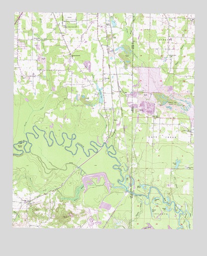
Domino, TX USGS Topographic Map
Click on map above to begin viewing in our Map Viewer.

This topographic map contains these locations and features:
Feature Name Type Latitude Longitude GNIS ID View Map
Alligator LakeLakeN33.2647°W94.0255°74626View Map
Apostolic Heritage ChurchChurchN33.3346°W94.0721°2016746View Map
Baker CreekStreamN33.2732°W94.0941°1372372View Map
Baker SloughStreamN33.2732°W94.0466°1372374View Map
Boardinghouse CreekStreamN33.2987°W94.0566°1352535View Map
Bright Star ChurchChurchN33.3687°W94.0591°1352893View Map
Browns LakeReservoirN33.2867°W94.0118°74701View Map
Buchanan CemeteryCemeteryN33.3288°W94.0664°1353112View Map
Buchanan First Baptist ChurchChurchN33.3651°W94.0744°2016754View Map
Buchanan Memorial ChurchChurchN33.3498°W94.0855°1353115View Map
Canaan Land ChurchChurchN33.3073°W94.0032°47366View Map
Crutchers CreekStreamN33.2998°W94.0624°1355446View Map
Cypress SloughStreamN33.2699°W94.0413°48319View Map
DominoPopulated PlaceN33.2651°W94.1152°1379671View Map
Domino CemeteryCemeteryN33.2610°W94.1091°1356148View Map
Elliott SloughLakeN33.2671°W94.0174°74818View Map
Ford IslandsIslandN33.2521°W94.0055°49156View Map
Ford SloughLakeN33.2552°W94.0042°49157View Map
Free Oneness ChurchChurchN33.3593°W94.1088°1357708View Map
Friendship ChurchChurchN33.3371°W94.0627°1357754View Map
Gifford Hill DamDamN33.3668°W94.0552°1854951View Map
Gifford Hill Gravel PitMineN33.3235°W94.0146°77014View Map
Gifford Hill LakeReservoirN33.3688°W94.0563°1854952View Map
Goss LakeLakeN33.2812°W94.0463°1358208View Map
Gum RidgeRidgeN33.2696°W94.0380°49720View Map
Harmony Grove ChurchChurchN33.3501°W94.0166°49875View Map
Hooker BranchStreamN33.3335°W94.0191°50289View Map
HootPopulated PlaceN33.3293°W94.0485°1379954View Map
Kennedy DamDamN33.3235°W94.0619°1854949View Map
Kennedy LakeReservoirN33.3280°W94.0652°1360580View Map
Liberty - Eylau Volunteer Fire Department Station 2BuildingN33.3419°W94.0945°2655649View Map
Lick BranchStreamN33.2721°W94.0113°51124View Map
Line Ferry (historical)CrossingN33.2707°W94.0419°63108View Map
Long SloughGutN33.2865°W94.0802°1361770View Map
Mathis SloughLakeN33.2755°W94.0333°75016View Map
Moes SloughLakeN33.2637°W94.0094°75028View Map
Pinhook LakeLakeN33.2601°W94.0289°75078View Map
Pleasant HillPopulated PlaceN33.3196°W94.0274°63116View Map
Pleasant Hill ChurchChurchN33.3157°W94.0249°53565View Map
Pleasant Hill Fire DepartmentBuildingN33.3069°W94.0021°2116983View Map
Rocky CreekStreamN33.3615°W94.0457°54132View Map
Saint Paul ChurchChurchN33.2643°W94.1141°1367299View Map
Snaggy LakeLakeN33.2611°W94.0173°75133View Map
Spring CreekStreamN33.3048°W94.1157°1368977View Map
SulphurPopulated PlaceN33.3129°W94.0557°1384147View Map
Trinity Volunteer Fire DepartmentBuildingN33.3714°W94.0008°2117222View Map
Whites Camp LakeLakeN33.2860°W94.0046°75220View Map
Wilson BendBendN33.2965°W94.1202°1371701View Map

Note: Coordinates in the location and feature list above are referenced to NAD83 datum.


Copyright (C) 2008-2025 Ryan Niemi / Sunset Dynamics ... All Rights Reserved