TopoQuest Logo
Do you find TopoQuest useful?
Help keep TopoQuest running and adding new maps/features by donating!
Bitcoin:  19c7KJd3qBynnjoSw5npx9KScwjBe4ifkT
Litecoin:  LXs6TkuXGGXo1vDsWCkWVdjQX94eUKd6ui
Home View Maps Find Maps Find Places Resources & Links


Mandeville, Arkansas Topographic Map

USGS Map Title: Mandeville, AR
USGS Map MRC: 33093D8
DRG (GeoTIFF) Download: o33093d8.tif


Neighboring USGS Topographic Map Quads:


  Ogden, AR  
33094E1
 

  Homan, AR  
33093E8
 

  Fulton, AR  
33093E7
 

  Texarkana, TX  
33094D1
 

  Mandeville, AR  
33093D8
 

  Fouke NE, AR  
33093D7
 

  Domino, TX  
33094C1
 

  Fouke, AR  
33093C8
 

  Fouke SE, AR  
33093C7


Map MRC Location:

N34°
W94°
N34°
W93°
H8 H7 H6 H5 H4 H3 H2 H1
G8 G7 G6 G5 G4 G3 G2 G1
F8 F7 F6 F5 F4 F3 F2 F1
E8 E7 E6 E5 E4 E3 E2 E1
D8 D7 D6 D5 D4 D3 D2 D1
C8 C7 C6 C5 C4 C3 C2 C1
B8 B7 B6 B5 B4 B3 B2 B1
A8 A7 A6 A5 A4 A3 A2 A1
N33°
W94°
N33°
W93°

Mandeville, AR USGS 1:24K Topographic Map Preview:
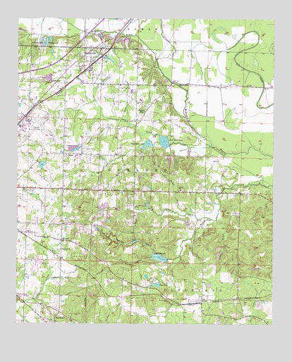
Mandeville, AR USGS Topographic Map
Click on map above to begin viewing in our Map Viewer.

This topographic map contains these locations and features:
Feature Name Type Latitude Longitude GNIS ID View Map
Boyce LakeReservoirN33.3911°W93.9317°75658View Map
Boyce Lake DamDamN33.3921°W93.9302°81179View Map
Buford LakeReservoirN33.4835°W93.9554°80387View Map
Buford Lake DamDamN33.4835°W93.9569°80386View Map
Camp HuntLocaleN33.4118°W93.9549°47322View Map
City of TexarkanaCivilN33.4365°W93.9961°2405580View Map
Cleveland CemeteryCemeteryN33.4723°W93.9810°47851View Map
Coca Cola LakeReservoirN33.4022°W93.9305°75677View Map
Coca Cola Lake DamDamN33.4012°W93.9263°80395View Map
Comer BranchStreamN33.4179°W93.9027°47944View Map
Cox LakeReservoirN33.4911°W93.9505°80385View Map
Cox Lake DamDamN33.4918°W93.9519°80384View Map
Few Memorial United Methodist ChurchChurchN33.3762°W93.9827°76921View Map
Forky Deer CreekStreamN33.4179°W93.9049°49176View Map
Gary E Cobb Middle SchoolSchoolN33.3767°W93.8816°2039352View Map
GenoaPopulated PlaceN33.3837°W93.9096°49366View Map
Genoa Baptist ChurchChurchN33.3846°W93.9157°63098View Map
Genoa Central Elementary SchoolSchoolN33.3767°W93.8803°83410View Map
Genoa Post OfficePost OfficeN33.3837°W93.9158°84239View Map
Genoa Volunteer Fire DepartmentBuildingN33.3837°W93.9151°2116472View Map
GertrudePopulated PlaceN33.4090°W93.9785°77010View Map
Gill LakeReservoirN33.4418°W93.9258°80541View Map
Gill Lake DamDamN33.4435°W93.9269°80540View Map
Harrison ChapelChurchN33.4621°W93.9385°49910View Map
Harrison Chapel CemeteryCemeteryN33.4585°W93.9418°49912View Map
KUKB-FM (Texarkana)TowerN33.3776°W93.9441°85248View Map
Lakewood EstatesPopulated PlaceN33.4246°W93.9563°63107View Map
Lifenet Air AmbulanceBuildingN33.4538°W93.9982°2119034View Map
Lower Moore LakeReservoirN33.4498°W93.9285°75778View Map
Macedonia ChurchChurchN33.4729°W93.9216°51562View Map
Macks Airport (historical)AirportN33.3960°W93.9835°83845View Map
MandevillePopulated PlaceN33.4818°W93.9641°51634View Map
Mandeville Volunteer Fire DepartmentBuildingN33.4828°W93.9628°2116757View Map
Morgan BranchStreamN33.4198°W93.9163°52184View Map
Mount Oba CemeteryCemeteryN33.3851°W93.9263°52326View Map
Mount PleasantPopulated PlaceN33.3771°W93.9813°58226View Map
Old Bitty LakeReservoirN33.4088°W93.9428°81178View Map
Old Bitty Lake DamDamN33.4085°W93.9435°81177View Map
Polk CemeteryCemeteryN33.3996°W93.9380°53660View Map
Robinson Lake DamDamN33.4918°W93.9835°80382View Map
RondoPopulated PlaceN33.4446°W93.9777°58517View Map
Rondo CemeteryCemeteryN33.4468°W93.9677°54181View Map
Shiloh ChurchChurchN33.4301°W93.9205°54785View Map
Smith LakeReservoirN33.4400°W93.9882°80390View Map
Smith Lake DamDamN33.4401°W93.9885°80389View Map
Tennessee Baptist ChurchChurchN33.4051°W93.9788°78538View Map
Tennessee BranchStreamN33.4026°W93.9205°78537View Map
Texarkana Air Force Station (historical)MilitaryN33.4558°W93.9986°2090212View Map
Texarkana Fire Department Station 4BuildingN33.4271°W93.9992°2117200View Map
Texarkana Regional Airport Rescue and Fire DepartmentBuildingN33.4542°W93.9960°2117205View Map
Texarkana Regional Airport-Webb FieldAirportN33.4565°W93.9936°83843View Map
Township of GarlandCivilN33.4547°W93.9298°69186View Map
Turkey CreekStreamN33.4476°W93.9052°55712View Map
Upper Moore LakeReservoirN33.4486°W93.9366°75873View Map
Upper Moore Lake DamDamN33.4504°W93.9360°80388View Map
Wadley LakeReservoirN33.4922°W93.9851°75877View Map
Williams LakeReservoirN33.4907°W93.9881°80381View Map
Williams Lake DamDamN33.4918°W93.9885°80380View Map
Wona (historical)Populated PlaceN33.3912°W93.9596°63130View Map
Wooten LakeReservoirN33.4230°W93.9575°80392View Map
Wooten Lake DamDamN33.4235°W93.9569°80391View Map

Note: Coordinates in the location and feature list above are referenced to NAD83 datum.


Copyright (C) 2008-2025 Ryan Niemi / Sunset Dynamics ... All Rights Reserved