TopoQuest Logo
Do you find TopoQuest useful?
Help keep TopoQuest running and adding new maps/features by donating!
Bitcoin:  19c7KJd3qBynnjoSw5npx9KScwjBe4ifkT
Litecoin:  LXs6TkuXGGXo1vDsWCkWVdjQX94eUKd6ui
Home View Maps Find Maps Find Places Resources & Links


Doniphan South, Missouri Topographic Map

USGS Map Title: Doniphan South, MO
USGS Map MRC: 36090E7
DRG (GeoTIFF) Download: o36090e7.tif


Neighboring USGS Topographic Map Quads:


  Briar, MO  
36090F8
 

  Doniphan North, MO  
36090F7
 

  Flatwoods, MO  
36090F6
 

  Poynor, MO  
36090E8
 

  Doniphan South, MO  
36090E7
 

  Oxly, MO  
36090E6
 

  Maynard, AR  
36090D8
 

  Supply, AR  
36090D7
 

  Datto, AR  
36090D6


Map MRC Location:

N37°
W91°
N37°
W90°
H8 H7 H6 H5 H4 H3 H2 H1
G8 G7 G6 G5 G4 G3 G2 G1
F8 F7 F6 F5 F4 F3 F2 F1
E8 E7 E6 E5 E4 E3 E2 E1
D8 D7 D6 D5 D4 D3 D2 D1
C8 C7 C6 C5 C4 C3 C2 C1
B8 B7 B6 B5 B4 B3 B2 B1
A8 A7 A6 A5 A4 A3 A2 A1
N36°
W91°
N36°
W90°

Doniphan South, MO USGS 1:24K Topographic Map Preview:
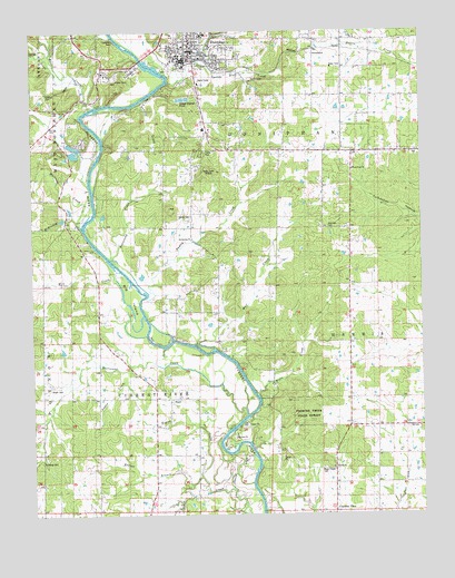
Doniphan South, MO USGS Topographic Map
Click on map above to begin viewing in our Map Viewer.

This topographic map contains these locations and features:
Feature Name Type Latitude Longitude GNIS ID View Map
Amity ChurchChurchN36.6231°W90.7707°743152View Map
Barkadare SchoolSchoolN36.5931°W90.7843°713643View Map
Beasley CreekStreamN36.6053°W90.8423°713832View Map
Beaucamp CreekStreamN36.5664°W90.8501°713834View Map
Bellview East SchoolSchoolN36.6148°W90.7646°713934View Map
Bethel ChurchChurchN36.5148°W90.7654°714040View Map
Bethlehem ChurchChurchN36.5714°W90.8240°743154View Map
Big IslandIslandN36.5551°W90.8423°714183View Map
Bluff CottageLocaleN36.5726°W90.8593°714441View Map
Briar CreekStreamN36.6042°W90.8585°749015View Map
Cedar LodgeLocaleN36.5364°W90.8068°715613View Map
City of DoniphanCivilN36.6234°W90.8219°2394544View Map
Current River Volunteer Fire DepartmentBuildingN36.6216°W90.7799°2621488View Map
Currentview Elementary School (historical)SchoolN36.5014°W90.7792°2560442View Map
Daltons Mill (historical)LocaleN36.5631°W90.8493°735253View Map
Davis CutoffStreamN36.5067°W90.8108°716729View Map
Dizmang CemeteryCemeteryN36.5139°W90.8726°743158View Map
Dizmang School (historical)SchoolN36.5228°W90.8715°716927View Map
DoniphanPopulated PlaceN36.6209°W90.8235°749678View Map
Doniphan Fire DepartmentBuildingN36.6180°W90.8289°2620414View Map
Doniphan Police DepartmentBuildingN36.6170°W90.8290°2752504View Map
Doniphan Post OfficePost OfficeN36.6192°W90.8256°2783174View Map
Dudley CreekStreamN36.5595°W90.8423°717150View Map
Dudleys ClubLocaleN36.5956°W90.8512°717152View Map
Eagan CreekStreamN36.5101°W90.8215°717232View Map
Everett BranchStreamN36.5070°W90.8248°717683View Map
Fourche Creek State ForestForestN36.5262°W90.7868°743156View Map
Gartman CemeteryCemeteryN36.6092°W90.8701°743151View Map
Gartman RockPillarN36.6217°W90.8473°718944View Map
Goose Lake (historical)LakeN36.5173°W90.8054°718594View Map
Greenwood SchoolSchoolN36.5303°W90.7718°718844View Map
Hancock CemeteryCemeteryN36.5737°W90.7796°743155View Map
Hancock School (historical)SchoolN36.5739°W90.7804°735252View Map
Hurricane CreekStreamN36.5256°W90.8068°750426View Map
KDFN-AM (Doniphan)TowerN36.6148°W90.8232°759265View Map
Klenn CreekStreamN36.5853°W90.8568°735254View Map
KOEA-FM (Doniphan)TowerN36.5889°W90.8196°754237View Map
LedePopulated PlaceN36.6167°W90.8168°736003View Map
Lingo CreekStreamN36.6178°W90.8687°750726View Map
Logan CreekStreamN36.5376°W90.8438°721419View Map
Loreys CabinsLocaleN36.5509°W90.8382°721571View Map
Matthews CabinsLocaleN36.5459°W90.8296°721979View Map
McKinney CreekStreamN36.5756°W90.8601°751003View Map
Merrell BranchStreamN36.5223°W90.8210°735251View Map
Mill CreekStreamN36.5587°W90.8460°751066View Map
Mill Creek School (historical)SchoolN36.5564°W90.8735°722344View Map
Mizell CemeteryCemeteryN36.5323°W90.8696°722503View Map
Mulberry CreekStreamN36.5806°W90.8576°751225View Map
OwenmontPopulated PlaceN36.6201°W90.7837°741131View Map
Pine Hill HollowValleyN36.6209°W90.8710°751610View Map
Pope Chapel (historical)ChurchN36.5112°W90.7818°724749View Map
Pope Chapel CemeteryCemeteryN36.5123°W90.7821°743157View Map
PrattPopulated PlaceN36.5301°W90.8312°724906View Map
Pratt Church (historical)ChurchN36.5284°W90.8304°735250View Map
Pratt School (historical)SchoolN36.5273°W90.8312°735248View Map
Purman Community Volunteer Fire DepartmentBuildingN36.5450°W90.7737°2621486View Map
Quick CreekStreamN36.6170°W90.8207°751782View Map
Ripley ChapelChurchN36.5845°W90.8235°725319View Map
Ripley County Sheriff's OfficeBuildingN36.6190°W90.8277°2752156View Map
Sanky Hall (historical)ChurchN36.5151°W90.8729°735249View Map
Sipes ClubLocaleN36.5826°W90.8548°726488View Map
Southeast Health Medical Center Ripley CountyHospitalN36.6213°W90.8258°2655037View Map
Spring Bluff CreekStreamN36.6112°W90.8307°726882View Map
Towles CemeteryCemeteryN36.5762°W90.8243°727727View Map
Towles School (historical)SchoolN36.5706°W90.8246°727729View Map
Township of Current RiverCivilN36.5267°W90.8381°767282View Map
Township of HarrisCivilN36.5385°W90.7544°767286View Map
Township of West DoniphanCivilN36.5983°W90.8732°767297View Map
Wells CreekStreamN36.5309°W90.8037°728500View Map
West Point ChurchChurchN36.5889°W90.7715°728609View Map
West Point SchoolSchoolN36.5556°W90.7723°728612View Map
Wolf CreekStreamN36.5437°W90.8221°735923View Map

Note: Coordinates in the location and feature list above are referenced to NAD83 datum.


Copyright (C) 2008-2025 Ryan Niemi / Sunset Dynamics ... All Rights Reserved