TopoQuest Logo
Do you find TopoQuest useful?
Help keep TopoQuest running and adding new maps/features by donating!
Bitcoin:  19c7KJd3qBynnjoSw5npx9KScwjBe4ifkT
Litecoin:  LXs6TkuXGGXo1vDsWCkWVdjQX94eUKd6ui
Home View Maps Find Maps Find Places Resources & Links


Poynor, Missouri Topographic Map

USGS Map Title: Poynor, MO
USGS Map MRC: 36090E8
DRG (GeoTIFF) Download: o36090e8.tif


Neighboring USGS Topographic Map Quads:


  Bardley, MO  
36091F1
 

  Briar, MO  
36090F8
 

  Doniphan North, MO  
36090F7
 

  Gatewood, MO  
36091E1
 

  Poynor, MO  
36090E8
 

  Doniphan South, MO  
36090E7
 

  Warm Springs, AR  
36091D1
 

  Maynard, AR  
36090D8
 

  Supply, AR  
36090D7


Map MRC Location:

N37°
W91°
N37°
W90°
H8 H7 H6 H5 H4 H3 H2 H1
G8 G7 G6 G5 G4 G3 G2 G1
F8 F7 F6 F5 F4 F3 F2 F1
E8 E7 E6 E5 E4 E3 E2 E1
D8 D7 D6 D5 D4 D3 D2 D1
C8 C7 C6 C5 C4 C3 C2 C1
B8 B7 B6 B5 B4 B3 B2 B1
A8 A7 A6 A5 A4 A3 A2 A1
N36°
W91°
N36°
W90°

Poynor, MO USGS 1:24K Topographic Map Preview:
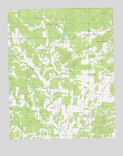
Poynor, MO USGS Topographic Map
Click on map above to begin viewing in our Map Viewer.

This topographic map contains these locations and features:
Feature Name Type Latitude Longitude GNIS ID View Map
Avon Gibson LakeReservoirN36.5029°W90.9284°765420View Map
Bellview West SchoolSchoolN36.5226°W90.9932°748780View Map
Bonds CreekStreamN36.5273°W90.9679°748962View Map
BurrPopulated PlaceN36.5020°W90.9862°749129View Map
Dalton CemeteryCemeteryN36.5007°W90.9768°749563View Map
DoylePopulated PlaceN36.5998°W90.9098°740531View Map
Doyle Post OfficePost OfficeN36.5998°W90.9098°760070View Map
East Fork Fourche CreekStreamN36.5487°W90.9557°749774View Map
Flat Top SchoolSchoolN36.5951°W90.9229°749941View Map
Fourche CreekStreamN36.5167°W90.9510°749969View Map
Fourche Creek Watershed Number 12 DamDamN36.5125°W90.9407°765421View Map
Fourche Creek Watershed Number 13 DamDamN36.5015°W90.9283°765419View Map
Fourche Creek Watershed Number 7 DamDamN36.5967°W90.9335°765185View Map
Fourche LakeLakeN36.5978°W90.9337°754059View Map
Gatewood Volunteer Fire Department Station 2BuildingN36.5855°W90.9547°2621181View Map
Glen Holland LakeReservoirN36.5992°W90.9340°765186View Map
Kennon CemeteryCemeteryN36.6084°W90.9596°750589View Map
LeibigPopulated PlaceN36.5487°W90.9515°750683View Map
Little CemeteryCemeteryN36.6226°W90.9862°750752View Map
Mount Olive ChurchChurchN36.6042°W90.8843°753671View Map
Murrell CemeteryCemeteryN36.5037°W90.9237°753662View Map
New Home ChurchChurchN36.5492°W90.8862°751286View Map
North Fork Fourche CreekStreamN36.5539°W90.9607°751339View Map
Old Ponder CemeteryCemeteryN36.5831°W90.9873°753435View Map
Patterson CemeteryCemeteryN36.5242°W90.9465°753664View Map
Pigeon Roost HollowValleyN36.5314°W90.8918°751579View Map
Plunk CemeteryCemeteryN36.5651°W90.9271°753668View Map
Plunk SchoolSchoolN36.5662°W90.9368°751677View Map
PonderPopulated PlaceN36.5839°W90.9890°751701View Map
Ponder CemeteryCemeteryN36.5814°W90.9793°753666View Map
Ponder School (historical)SchoolN36.5764°W90.9685°751703View Map
PoynorPopulated PlaceN36.5203°W90.9071°751740View Map
Poynor Census Designated PlaceCensusN36.5252°W90.8996°2587108View Map
Poynor ChurchChurchN36.5251°W90.9157°753663View Map
Poynor School (historical)SchoolN36.5189°W90.9054°735247View Map
Poynor Volunteer Fire DepartmentBuildingN36.5243°W90.9053°2621566View Map
Price CemeteryCemeteryN36.5823°W90.8885°753669View Map
Price SchoolSchoolN36.5892°W90.8810°751759View Map
Ripley County FairgroundLocaleN36.6009°W90.8979°753670View Map
Rosson School (historical)SchoolN36.6023°W90.9860°751967View Map
Sugar Tree School (historical)SchoolN36.5184°W90.9485°752418View Map
Township of PoynorCivilN36.5315°W90.9017°767291View Map
Township of UnionCivilN36.5530°W90.9689°767294View Map
Union Grove CemeteryCemeteryN36.5598°W90.9982°753667View Map
Union SchoolSchoolN36.5598°W90.9962°752665View Map
West Fork Fourche CreekStreamN36.5165°W90.9512°752818View Map

Note: Coordinates in the location and feature list above are referenced to NAD83 datum.


Copyright (C) 2008-2025 Ryan Niemi / Sunset Dynamics ... All Rights Reserved