TopoQuest Logo
Do you find TopoQuest useful?
Help keep TopoQuest running and adding new maps/features by donating!
Bitcoin:  19c7KJd3qBynnjoSw5npx9KScwjBe4ifkT
Litecoin:  LXs6TkuXGGXo1vDsWCkWVdjQX94eUKd6ui
Home View Maps Find Maps Find Places Resources & Links


Dovesville, South Carolina Topographic Map

USGS Map Title: Dovesville, SC
USGS Map MRC: 34079D8
DRG (GeoTIFF) Download: o34079d8.tif


Neighboring USGS Topographic Map Quads:


  Patrick, SC  
34080E1
 

  Cash, SC  
34079E8
 

  Society Hill, SC  
34079E7
 

  Hartsville North, SC  
34080D1
 

  Dovesville, SC  
34079D8
 

  Mont Clare, SC  
34079D7
 

  Hartsville South, SC  
34080C1
 

  Darlington West, SC  
34079C8
 

  Darlington East, SC  
34079C7


Map MRC Location:

N35°
W80°
N35°
W79°
H8 H7 H6 H5 H4 H3 H2 H1
G8 G7 G6 G5 G4 G3 G2 G1
F8 F7 F6 F5 F4 F3 F2 F1
E8 E7 E6 E5 E4 E3 E2 E1
D8 D7 D6 D5 D4 D3 D2 D1
C8 C7 C6 C5 C4 C3 C2 C1
B8 B7 B6 B5 B4 B3 B2 B1
A8 A7 A6 A5 A4 A3 A2 A1
N34°
W80°
N34°
W79°

Dovesville, SC USGS 1:24K Topographic Map Preview:
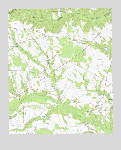
Dovesville, SC USGS Topographic Map
Click on map above to begin viewing in our Map Viewer.

This topographic map contains these locations and features:
Feature Name Type Latitude Longitude GNIS ID View Map
Adurndale Farms PondReservoirN34.3921°W79.9560°1238456View Map
AntiochPopulated PlaceN34.4446°W79.9523°1240794View Map
Antioch ChurchChurchN34.4454°W79.9526°1244905View Map
AuburnPopulated PlaceN34.3754°W79.9759°1244940View Map
Bethlehem CemeteryCemeteryN34.4613°W79.9945°1240806View Map
Bethlehem ChurchChurchN34.4610°W79.9942°1246836View Map
Birdstown CrossroadsPopulated PlaceN34.4629°W79.9934°1246893View Map
Black Creek Academy (historical)SchoolN34.3849°W79.9065°1240807View Map
Black Creek Baptist Church (historical)ChurchN34.3846°W79.9065°1240808View Map
Black Creek CemeteryCemeteryN34.3863°W79.9078°1220769View Map
Boggy SwampStreamN34.4107°W79.9803°1246932View Map
Carroll Chapman Pond Dam D-3531DamN34.4335°W79.9765°1240064View Map
Centerville CemeteryCemeteryN34.3915°W79.9984°1221484View Map
Centerville ChurchChurchN34.3904°W79.9992°1247234View Map
Centerville School (historical)SchoolN34.3915°W79.9992°1240820View Map
Chambers CemeteryCemeteryN34.3857°W79.9517°1221496View Map
Chapmans PondReservoirN34.4222°W79.9437°1221513View Map
Cokers Mill (historical)LocaleN34.4996°W79.8756°1235633View Map
Darlington County AirportAirportN34.4463°W79.8855°2650852View Map
Darlington County Fire Department ByrdtownBuildingN34.4624°W79.9951°2578583View Map
Darlington County Fire Department CentervilleBuildingN34.3941°W79.9828°2578736View Map
Darlington County Fire Department DovesvilleBuildingN34.3981°W79.8801°2578232View Map
Darlington County Fire Department JetportBuildingN34.4449°W79.8844°2578737View Map
Darlington Pond Dam D-3529DamN34.4902°W79.9748°1240065View Map
DovesvillePopulated PlaceN34.4024°W79.8951°1247556View Map
Dovesville Baptist ChurchChurchN34.4010°W79.8853°1240850View Map
Dovesville Church of GodChurchN34.4085°W79.8887°1240851View Map
Evans Mill (historical)LocaleN34.4988°W79.9231°1235647View Map
Everlasting BranchStreamN34.4040°W79.9381°1222323View Map
Fraser CemeteryCemeteryN34.3851°W79.9892°1222542View Map
Gilbert LakeReservoirN34.3967°W79.9498°1222699View Map
Greenplains (historical)Populated PlaceN34.4793°W79.9826°1240878View Map
Harris CreekStreamN34.4960°W79.9198°1223057View Map
Hartsville Army Air Field (historical)MilitaryN34.4500°W79.8903°1985995View Map
Horse CreekStreamN34.3765°W79.9209°1246067View Map
Howle CemeteryCemeteryN34.4682°W79.9862°1223363View Map
Lake DarpoReservoirN34.4588°W79.8828°1221930View Map
Leavensworth (historical)Populated PlaceN34.4096°W79.9403°1240911View Map
Leavenworth BranchStreamN34.4332°W79.9462°1223856View Map
Little Boggy SwampStreamN34.4193°W79.9937°1223961View Map
Little Seed BranchStreamN34.4440°W79.9484°1224050View Map
McIntosh Mill (historical)LocaleN34.4149°W79.9901°1240920View Map
McIntosh MillpondReservoirN34.4155°W79.9914°1246597View Map
Mount Zion ChurchChurchN34.3968°W79.9026°1249720View Map
Mount Zion School (historical)SchoolN34.4054°W79.9012°1240932View Map
New Hopewell ChurchChurchN34.4485°W79.9498°1249836View Map
Old Black Creek CemeteryCemeteryN34.3846°W79.9048°1225170View Map
Robinson School (historical)SchoolN34.4477°W79.9503°1240966View Map
Ross Strip (historical)AirportN34.4227°W79.8848°1251988View Map
Seed BranchStreamN34.4046°W79.9353°1250828View Map
South Carolina Noname 16006 D-3533 DamDamN34.4202°W79.9415°1238453View Map
South Carolina Noname 16009 D-3534 DamDamN34.3935°W79.9548°1238455View Map
South Carolina Noname 16023 D-3530 DamDamN34.4577°W79.8806°1238467View Map
South Carolina Noname 16108 D-3532 DamDamN34.4235°W79.9948°1238463View Map
Sumpayrac Mill (historical)LocaleN34.4871°W79.9567°1235781View Map
Van CemeteryCemeteryN34.3993°W79.9781°1227333View Map
White Plains School (historical)SchoolN34.3968°W79.9023°1241022View Map

Note: Coordinates in the location and feature list above are referenced to NAD83 datum.


Copyright (C) 2008-2024 Ryan Niemi / Sunset Dynamics ... All Rights Reserved